Good morning. I did a twitter video last night you can find on the right hand pane of this webpage. In the video I discuss the chances of another winter storm on Saturday. The bottom line is, at this time it is still very up in the air. Most models do not have a storm threat with the exception of the European model. In these situations either the European model is on to something or it is out to lunch. By tonight, we should have enough clarity to start to make predictions.
In the meantime, we will have a frontal passage on Thursday morning which could drop a little bit of light snow across the area...

The jury is still out if this amplifies enough north to cause a few inches of snow but at this time I assign a 50% chance. We will discuss this more tomorrow morning.
Back to the weekend threat, the European model has been very amplified with the storm energy in the jet stream and has a storm closer to the coast...
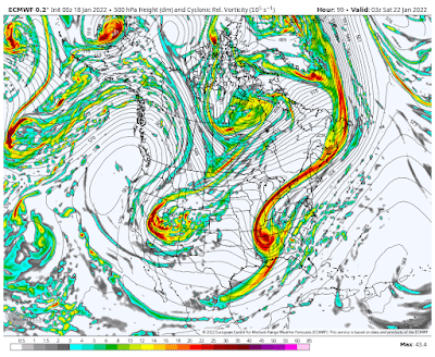

GFS and all other major model guidance says storm stays off the coast...

The European is either out to lunch or is on to something here. Usually I would say in this situation it is out to lunch. The only area of pause I have is that storm as of late have been trending west with time. This makes be think there is a shot for something on Saturday.
Stay tuned, more to come.
No comments:
Post a Comment