The main impacts for the NYC metro are Monday all day. No changes to my snowfall map. Next update will be tomorrow morning.
Saturday, November 30, 2019
Sat Night Video: This Will Come Down to The Wire
The video below discusses my updated thoughts and evolution of tomorrow's storm system. Models are hinting at a very unpredictable back end band of impressive snow Monday.
The main impacts for the NYC metro are Monday all day. No changes to my snowfall map. Next update will be tomorrow morning.
The main impacts for the NYC metro are Monday all day. No changes to my snowfall map. Next update will be tomorrow morning.
Saturday Morning Storm Update: Tricky Forecast
Good morning. Here is my updated forecast for Sunday through Monday. Usual 7pm Video update tonight as this storm evolves.

Summary:


Summary:
- Winter storm on track to impact the region with a mix of rain, ice, and heavy snow
- For Purple Zone:
- A heavy long duration snowfall event is to be expected with over a foot of snow in many spots
- For the Dark Blue Zone:
- Sleet and freezing rain moves in by mid morning Sunday for areas in NW NJ, NE PA, CT
- The ice changes to snow by late Sunday night/Early Monday morning
- Several inches of snow can pile up Monday morning
- For Light Blue Zone:
- Some sleet to start Sunday morning but a transition to rain
- Rain changes to snow on Monday morning giving this region a quick few inches
- For Green Zone:
- All rain maybe a few flakes by Monday afternoon, coating in some spots possible
So this continues to be a challenging forecast for the fringe areas of this storm (dark blue). I discussed in my video last night how NNJ and NE PA are in the wildcard zone for this storm. This is because we still need to see how this backend snow band evolves.
Latest models do indicate we see this band get just into NE PA and NNJ by Monday Morning. Below is the latest European model from Sunday morning to Monday night...

Notice the pivot of the storm at the end to throw that band back into the area. This is the detail that will still be moving around on models. IF this stays more north then snowfall amounts are cut down significantly across NJ and PA. If we get a shift south, then we get more heavy snow over NNJ. It will all come down to the placement of the upper level low....

If this feature at 18000 ft ends up being a little tighter and further south, the snowfall will shift south. If it ends up more north the snow shifts more north. Models will be wobbling around with this feature through tomorrow. That makes pinpointing snowfall within 50 miles extremely difficult
I said it yesterday and I will say it again, this storm will be surprising us through tomorrow morning with updated model projections moving these features around.
Stay tuned for evening update.
Friday, November 29, 2019
Friday: Significant Winter Storm to Impact Region Sun & Monday
Good morning. A signifigant winter storm will impact the Northeast Sunday and Monday.
My map below is my updated forecast. I will also have a video out tonight around 7pm.

Summary:

My map below is my updated forecast. I will also have a video out tonight around 7pm.

- A low pressure system approaches the area from the west on late Sunday morning, early afternoon
- Areas across interior PA and NW NJ will see all snow and ice as temperatures should not go above freezing for the duration of this event
- Areas to the southeast of I-287 expect mostly rain to start Sunday afternoon
- The low pressure system then redevelops into a powerful storm off the NJ coast on Sunday night into Monday
- expect heavy snow to break out across most of New England and NNJ by the time we get towards Monday morning
- This is where several inches of snow can pile up in those darker blue zones
- Rain should still hold on for areas south of I-78
- By Mid to late morning Monday rain should change to back end snow for most areas south of I-78
- A few accumulations are possible in these areas by Monday evening
- Storm then starts to pull away by Monday night
- I have concerns of this storm making last min shifts to the northeast
- this would mean NNJ doesn't see as much heavy snow
So as you can see this is a very complex and tricky storm system. The reason is we do no fully know exactly where this low pressure center will redevelop off the NJ coast. IF it develops more north than modeled then only New England sees the heavy snow. If it develops just south of Long Island then NNJ gets in on the heavy snow Sunday night.
The model European model below (from Sunday morning to Monday night) gives a general idea on how this may evolve. My concern is the European is a little too far south with the heavy snow and this can end up adjusting more north. This means NNJ is still in the wildcard position for this storm...

First off, this is a very signifigant storm system. Notice that back end band of heavy snow being showed towards the end of the loop. My concern stems on if this shifts more northeast compared to whats shown. If that happens then its mostly all of southern New England that sees the heavy snow. I have been burned before on storms like this making last min shifts.
Notice even areas down to Phili can see snow at the tail end of this causing some accumulations.
I am going to cut a video tonight around 6 or 7pm to discuss the evolution of the major winter storm.
Stay tuned.
Thursday, November 28, 2019
Thanksgiving Day: Preliminary Storm Forecast
Happy Thanksgiving! Before everyone gets moving about for the day I wanted to give my updated thoughts on the storm system that will impact the region on Sunday. At this time, I am favoring impacts to mostly be to the northwest, especially over New England and off the coasts. There is a chance however that we see some back end snowfall from this which will be hard to predict this far out.
Here is my preliminary forecast for Sunday. This is subject to change and is my best estimate on what will happen given all the info I have looked at. This is a very tough one to forecast and the final outcome can look a lot different than what you see below:

This storm system will feature a mixed bag of precipitation.
For the green zone, I am not expecting major impacts at this time. Mostly rain with some snow possible on the back end of this early Monday morning.
For the pink zone, mixed precipitation will initially fall Sunday morning before giving way to some rain as well. It is possible however that this zone sees some accumulating back end snow early Monday morning.
For the dotted blue/pink zone, this is the big wildcard. I can see this turning out to be a signifigant winter storm but it just is too early to make the bold call.
For the dark blue zone, I am very confident there will be a moderate to signifigant snowfall
Models are pretty spread still on what this storm does. This will likely continue for the next day or so.
The reason for this is we have a low pressure system cutting inland that will redevelop off the coast. Anytime you have a redeveloping low the models struggle. You can see the overall evolution of this below...

Zooming in closer...
The GFS is the warmest and doesn't impact the area too hard except for the north...

The European is more aggressive with winter weather making it further south with wraparound snow towards the end of the event...

Using ensemble means, here is the probability of snow exceeding 3"...

Using historical analogs here is median snowfall...

As you can see my forecast map is a blend of many of these tools.
I will start to really hone in on this next several days. I am confident in one thing, that this will throw us some surprises from a forecasting standpoint over the next several days. I wouldn't even be surprised if models are still shifting 24 hours away from this event.
Stay tuned.
Wednesday, November 27, 2019
Wednesday Note: Trying to Hone In
Good morning. I do not have an awful lot to say this morning. Over the next 24 hours I think I will have enough data to make a preliminary call on Sunday's storm system. I will be updating again around 6pm tonight. From what I see now, winter weather should stay focused off the coasts in the Northern Mid-Atlantic (NW I-95) and New England. The core of this system should effect the heart of New England with a mixed bag of precipitation in other areas. For areas along the coasts especially NJ, I do not think this is a big winter weather maker.
For now, I think model ensemble probabilities of snowfall exceeding 1" give the best idea of where impacts can be from this...
 Notice the highest probabilities over heart of New England (orange) with moderate probabilities working their way into northern Mid-Atlantic(yellowish green). I looked at a lot of data and at this point I think this map sums things up the best.
I will have a bigger update later tonight around 6 pm.
For now, I think model ensemble probabilities of snowfall exceeding 1" give the best idea of where impacts can be from this...

I will have a bigger update later tonight around 6 pm.
Tuesday, November 26, 2019
Tuesday: Winter Storm Chances Increasing for Sunday-Monday
Good morning. To continue from where we left off yesterday, data continues to support a winter storm system Sunday-Monday along the east coast. As always, many details need to be worked out but there is enough on the table to start to take this seriously. I have updated the winter storm outlook banner to moderate confidence.
Summary:


Summary:
- Chances for a winter storm increasing Sunday into Monday
- Target region is northern Mid-Atlantic (Philly northward) into New England
- Threat type is mixed precipitation changing to snow for northern Mid-Atlantic and all Snow for New England
- this type of storm setup is New England biased
- Finer details need a few days to be worked out
So where we left off yesterday I showed the image below...

It is important to sniff out the overall pattern before you look at what is happening at the surface. What really drew my attention to this period was the presence of signifigant atmospheric blocking (50/50 low) which causes jet stream to buckle and high pressure to lock in over southern Canada (due to confluence or air coming together at high altitudes).
I have seen many times where the models struggle to handle the interaction between an approaching low pressure system and the locked in high pressure to the north in situations like this. In many cases the models are too aggressive driving the low too far into the high pressure. What normally ends up happening is the low/storm slides under the pressure area and redevelops off the coast sooner than the models initially indicate. I believe this is what we are now seeing the models start to pick up on.
Lets take a look at the European ensemble model...

Looking above, the image on the left is new model the one on the right is from 24 hours ago. Notice in the circled region the high pressure or orange color is stronger on the new run. The result is the storm undercuts sooner and maintains a little more cold air over the region...

As you can see the storm is forced to redevelop. This whole threat will come down to how soon this occurs. If it happens later its a warmer storm and just New England focused. If it happens sooner then its more winter weather to the south. This is what we need to work out over the next few days.
It really is too early to discuss snow amounts etc as this whole thing still can shift north or south. If we look at historical setups right now the highest probability for accumulating snowfall is in this region...

I do think we can see accumulating snow more south of this but at this time this is the best conservative forecast of where to expect the most impacts.
Stay tuned, daily updates and videos (if necessary) on tap.
Monday, November 25, 2019
Monday: Winter Pattern to Set In Early December
Good morning. A milder week gives way to colder conditions by Thanksgiving through the weekend. We then have a weather pattern developing that can support winter storm(s) for the first two weeks of December. The first period to watch for winter weather will be early next week for areas from the northern Mid-Atlantic into New England.
The winter storm outlook banner is also live again for the season. You can see it on the top of the website. I will update this as necessary.
So lets dive into it..
A storm system cuts to our west this week bringing mild conditions through Wednesday..

Things then cool down noticeably for Thanksgiving into the weekend and the overall weather pattern starts to turn favorable for winter storms...

Looking above is the pattern for the end of this weekend. This has a signature to it that is loaded with potential to produce a storm. The relationship between the block (high pressure over Greenland) and big vortex of low pressure over eastern Canada (50/50 low) will cause a big area of high pressure to develop over southern Canada and stay locked. This is signifigant because it becomes a cold air source and forces any storms that are developing to either have to slide under it or in most cases redevelop off the eastern seaboard.
At this time I am confident that at least New England can see a signifigant winter storm from this set up by early next week. Areas in the northern Mid-Atlantic (north of MD, S NJ, DE) are also in play if the high pressure is strong enough. We will have to keep a close eye on this.
The latest GFS model gives an idea on how this can play out...
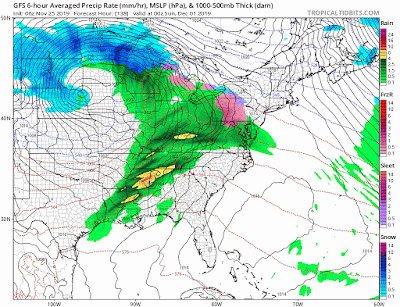
Notice how storm starts west but slides under high pressure and redevelops off coast by Monday.
We will keep a close on on this. The pattern then stays favorable for winter weather through the 2nd week of December. Things may be looking very white soon.
Friday, November 22, 2019
Friday Update: Pattern Idea on Track...Seasonable Weather Continued
Good morning and happy Friday. Our weather pattern continues to look dynamic over the next several weeks. We will see a lot of high pressure develop over the higher latitudes which will cause a lot of storm activity across the country Thanksgiving week. Despite this, I do not see any air masses that will be cold enough for any snow makers for the eastern seaboard. It is the week following Thanksgiving (1st week of December) that we can see our first shot at snow.
Starting off, we have a nice storm that will move into the area on Sunday. If it was 2 weeks later, this would be a great snow maker. For now its just interior mountain event...

The reason we do not see widespread snow despite the fact the low pressure is in a good spot is that there is too much warm pacific air in the country surrounding the storm. This is really just a case of climatology (too early in season).
From there Thanksgiving week looks very seasonable. It does warm up a little on Wednesday as a storm system passes to our west...
 In the wake of this things then cool down for Thanksgiving day with high pressure in control. Should be a chilly day and last into the weekend.
We then look to the 1st week of December. It is still very in the long range, but there is a chance of some winter weather along the east coast early that week form what I see.
We will discuss this further if things develop towards this idea.
Starting off, we have a nice storm that will move into the area on Sunday. If it was 2 weeks later, this would be a great snow maker. For now its just interior mountain event...

The reason we do not see widespread snow despite the fact the low pressure is in a good spot is that there is too much warm pacific air in the country surrounding the storm. This is really just a case of climatology (too early in season).
From there Thanksgiving week looks very seasonable. It does warm up a little on Wednesday as a storm system passes to our west...

We then look to the 1st week of December. It is still very in the long range, but there is a chance of some winter weather along the east coast early that week form what I see.
We will discuss this further if things develop towards this idea.
Tuesday, November 19, 2019
Tuesday Pattern Update: Some Positives & Some Negatives= Seasonable
Good morning. As we enter the next two weeks I am seeing a mixed bag of information regarding our weather pattern. On one hand, we will have high pressure over Greenland or a -NAO pattern develop. This is very encouraging as if this holds through winter things can really get wild. On the other hand however, we have a pacific pattern that does not look great. What I mean by that is the jet stream will allow warmer pacific air to enter the pattern next 2 weeks. If you sum the two components together I am led to believe it means seasonable conditions for our forecast area through the end of November. For Thanksgiving week a big storm system likely develops accross the central US around the middle of the week causing mild conditions along the east coast till the weekend. December than starts off seasonable. I think winter gets going 2nd half of December this year.
If there is room for a surprise in this pattern it will be early next week...

Although this doesn't look great to produce a storm along hte eastern seaboard (positive trough) things could change and this may spin up some type of storm system early next week along the east coast.
As we look at Thanksgiving week overall, here is the pattern to expect...

We have a great pattern over Greenland as mentioned, but the high pressure off the west coast is too far west. This means the colder and stormy weather moves to the central part of the country. There will likely be a big storm around the middle of next week in that region which is not good for travel...

This will bring a surge of mild air to the east coast Wednesday and Thanksgiving day with a cold front moving through by Thanksgiving weekend with some unsettled weather.
We then look to see how early December shapes up. I am not worried about seeing no winter weather on the east coast in November. Its very rare. However, once December hits then we are in the core of winter season and we need to see if we can hold the right pattern. Given the fact I think that -NAO pattern sticks around a few weeks I do not expect any major mild surges. With that being said winter may wait till 2nd half of December to get started this year.
On another note, there are clues emerging that we will see stratospheric warming develop 1st half of December. I will go into more detail on what this means in a future post.
Monday, November 18, 2019
Monday: Chilly Rain, Mtn Snow
Good morning. We have an offshore low spinning back some moisture today. Later tonight an upper level disturbance moves through causing mountain snow from Catskills to VT. No winter weather concerns for our area today.

More in depth post to come tomorrow on the overall weather pattern heading into Thanksgiving.

More in depth post to come tomorrow on the overall weather pattern heading into Thanksgiving.
Friday, November 15, 2019
Example of Atmospheric Blocking
Per my discussion yesterday, see recent run of the European model. Red is higher pressures and blue is basically energy. Due to the high pressure over Greenland and the western Atlantic the atmospheric flow is slowed down and "blocked". This allows energy to slowdown as well and potentially consolidate. This is why I think the upcoming pattern starting next week will feature alot of active weather and yes even snow for areas closer to the coast as we get closer to the end of the month. In the meantime, the ski areas keep pumping more accumulations.


Thursday, November 14, 2019
Thursday: A Look at The Long Range
Summary:
Good morning. We are now on the back end of this impressive cold spell. Things will start to moderate a little towards this weekend but still stay on the colder than normal side overall. In terms of storms, one storm should develop offshore Sunday into Monday while another one can potentially target the east coast on Wednesday. Not necessary a winter storm but something to keep an eye on over the next few days.
You can see below how models are flirting with two storm systems. One for Monday and one of Wednesday...
The GFS is more bullish for Monday...

The European model for Wednesday...

The atmosphere is starting to develop a "blocking pattern" which I will discuss more below. Due to this I think the chance that one of these storm threats can hit. The GFS is more bullish on Monday the European on Wednesday. There will not be a lot of cold air aloft available this time around so if a storm forms it is again an interior higher elevation snow threat. I will keep an eye on this.
The main thing I wanted to discuss today is how the overall weather pattern is setting up in the long range. I am seeing very favorable indicators being projected for the end of November to support cold and storm development along the eastern seaboard.
I try to keep things simple, so the image below sums up what I am looking at...

This image is valid for the week of Thanksgiving. A few key things that most of the models are showing for this time period that I like to see:
- Cold air moderates a little heading into this weekend but still remains on the chilly side
- Chance for coastal storm development Monday or Wednesday
- No threat for winter weather except at higher elevations of interior New England
- Models are spread on what system they want to strengthen
- Long range pattern is becoming favorable for colder and stormy weather due to high pressure (-NAO) pattern projected to form over Greenland
- Target period is end of next week through Thanksgiving
- Patterns like this allow cold air to lock in over the eastern US and energy to consolidate to form storms
- Will be important to see if the models verify on this pattern**
- There is a chance some moderation develops and things warm up for a period in December.
- Jury is still out on this
Good morning. We are now on the back end of this impressive cold spell. Things will start to moderate a little towards this weekend but still stay on the colder than normal side overall. In terms of storms, one storm should develop offshore Sunday into Monday while another one can potentially target the east coast on Wednesday. Not necessary a winter storm but something to keep an eye on over the next few days.
You can see below how models are flirting with two storm systems. One for Monday and one of Wednesday...
The GFS is more bullish for Monday...

The European model for Wednesday...

The atmosphere is starting to develop a "blocking pattern" which I will discuss more below. Due to this I think the chance that one of these storm threats can hit. The GFS is more bullish on Monday the European on Wednesday. There will not be a lot of cold air aloft available this time around so if a storm forms it is again an interior higher elevation snow threat. I will keep an eye on this.
The main thing I wanted to discuss today is how the overall weather pattern is setting up in the long range. I am seeing very favorable indicators being projected for the end of November to support cold and storm development along the eastern seaboard.
I try to keep things simple, so the image below sums up what I am looking at...

This image is valid for the week of Thanksgiving. A few key things that most of the models are showing for this time period that I like to see:
- A negative north Atlantic oscillation which is seen by high pressure over Greenland.
- When high pressure forms here, especially in western Greenland there is a favorable atmospheric response for cold and stormy weather
- A block in the Jet Stream
- Aided by the -NAO pattern the jet stream buckles over the east coast
- This means energy entering the pattern can consolidate and form storms
- Potential for cold high pressure to get locked in
- essential ingredient for snow closer to the coasts otherwise storms wash cold air away
- Usually aided by a -NAO pattern
We have not see too much of a -NAO pattern over recent years except for March of 2018 which was a wild month weather wise. It is the single most important factor for increasing the likelihood of storms developing and giving areas near the coast the shot at snow.
Now that doesn't guarantee anything but it does increase the chances IF THIS PROJECTION VERIFIES. Considering there is a lot of cold air available up in Canada due to increased snow cover late November and Early December are periods to watch for a winter storm. When long range forecasting, all we can do is target peroids that have an increased likelihood then hone in on anything that might develop.
Thats all for now.
Tuesday, November 12, 2019
Tuesday: Rain Moving Through, Few Flakes and Big Cold to Follow
Good morning. Our line of rain is currently over the area with snow to the northwest...

There is a large temperature contrast currently between coastal areas and inland as our cold front is approaching with temperatures in the high 20s to the west and 50's to the east...

As this front approaches next few hours some rain will change to light snow in scattered spots by late morning/early afternoon...


No accumulations (ex higher terrain dusting), just some flakes in the air potentially. It will be interesting to see if this pans out.
Temps then really crash tonight into tomorrow morning into the teens and low 20s..

By far coldest air mass of the season tomorrow. Highs will be in upper 20s to low 30s tomorrow. Things then moderate by the weekend a little.
Stay tuned.
Monday, November 11, 2019
Monday: First Flakes Possible Tomorrow Morning, Very Cold Wednesday
Overview:
Good morning. It will be a mild day across the region with temperatures in the upper 50's to lower 60's. To our west a frontal system is bringing a winter storm to areas of Western NY and New England. Over 6" of snow will be falling there today.
The front works it way towards our area tonight. Expect some light rain later tonight with temps then dropping rapidly by tomorrow morning. Some of this light rain will change to a little bit of light snow for most areas by tomorrow morning. Little or no snow accumulation is expected except for the higher elevations of NW NJ where up to 1/2" of snow can accumulate.
Temperatures then really crash for Wednesday where it will feel like Mid December. This cold lasts to the early weekend.
Lets take a look:
Frontal system to our west today bringing a good amount of snow to ski areas and western NY. I expect around 6" in these areas and up to a foot in the Ski Areas of northern VT.

By early tomorrow morning, the front gets towards the coast with light rain developing..

By the time we get towards daybreak the colder air rushes in and there is the CHANCE for a quick shot of light snow on the back end of this front...

All areas can potentially see few flakes fly.
I am not expecting any accumulations except for maybe a dusting over NW NJ higher elevations and PA. This is just going to be a few flakes in the air for a short period of time.
The real cold then comes in for Wednesday morning. Real feel temps will be in single digits to teens at daybreak...

Even by the afternoon temperatures will not feel like they are above freezing...

Again these are real feel temps. Actual temps will be higher in the low to mid 30's for highs Wednesday.
The cold lingers into the beginning of the weekend and then things start to moderate.
The pattern then should stay active for the long range but I do not expect any widespread winter weather for any areas near the coast over the next 2 weeks. More seasonable to slightly below seasonable conditions should develop.
The attention then turns towards December. The jury is still out right now. There is a lot of data to support a mild December. My winter forecast supports that idea at least to start. I have a feeling by Mid-December winter really gets rocking this year.
More to come.
Good morning. It will be a mild day across the region with temperatures in the upper 50's to lower 60's. To our west a frontal system is bringing a winter storm to areas of Western NY and New England. Over 6" of snow will be falling there today.
The front works it way towards our area tonight. Expect some light rain later tonight with temps then dropping rapidly by tomorrow morning. Some of this light rain will change to a little bit of light snow for most areas by tomorrow morning. Little or no snow accumulation is expected except for the higher elevations of NW NJ where up to 1/2" of snow can accumulate.
Temperatures then really crash for Wednesday where it will feel like Mid December. This cold lasts to the early weekend.
Lets take a look:
Frontal system to our west today bringing a good amount of snow to ski areas and western NY. I expect around 6" in these areas and up to a foot in the Ski Areas of northern VT.


By the time we get towards daybreak the colder air rushes in and there is the CHANCE for a quick shot of light snow on the back end of this front...

All areas can potentially see few flakes fly.
I am not expecting any accumulations except for maybe a dusting over NW NJ higher elevations and PA. This is just going to be a few flakes in the air for a short period of time.
The real cold then comes in for Wednesday morning. Real feel temps will be in single digits to teens at daybreak...

Even by the afternoon temperatures will not feel like they are above freezing...

Again these are real feel temps. Actual temps will be higher in the low to mid 30's for highs Wednesday.
The cold lingers into the beginning of the weekend and then things start to moderate.
The pattern then should stay active for the long range but I do not expect any widespread winter weather for any areas near the coast over the next 2 weeks. More seasonable to slightly below seasonable conditions should develop.
The attention then turns towards December. The jury is still out right now. There is a lot of data to support a mild December. My winter forecast supports that idea at least to start. I have a feeling by Mid-December winter really gets rocking this year.
More to come.
Sunday, November 10, 2019
Sunday Note: Fitst Flakes of Season Tuesday Morning
I will be going into more detail tomorrow morning but the first snowflakes of the season are likely Tuesday morning. A cold front will move into the region Monday night bringing with it rain and snow over Interior New England. By Tuesday morning the rain will change to a brief period of snow from NW to SE.
The snow will not last long but should last long enough to give the high elevations of NW NJ (above 800ft, Highlands Region), NE PA and NW CT 0.5-1" of snow. For all other areas expect to see some flakes but little of no accumulation expected. Minimal if any travel impacts for those areas.
For interior New England, especially the Ski Areas I expect 6"+ of new snow.
More tomorrow.
Saturday, November 9, 2019
Update Tomorrow Morning
Evaluating the chance for NW NJ to see some light accumulations and areas further east to see first flakes Tuesday morning.
Friday, November 8, 2019
Friday: Yesterday Summed it Up
Good morning. Big chill out there today! Just wait till tonight when temps crash into the 20s.
Summary:
Our weak storm system last night left a few inches of snow in the mountains of New England and a coating in other areas up there. To the south, it was mostly a cold rain. Cold temps are here to stay with some moderation by Monday. The big news making cold shot arrives Wednesday.
The storm system we have been discussing for Tuesday is being projected (for now) as I expected yesterday. Remember I mentioned the chances for snow near coasts was unlikely due to no blocking in place and the storm all coming down to timing between the northern and southern jet streams. Currently models have a inland frontal wave of snow with maybe the chance for a changeover for areas just off the coast as the storm ends.
The European model shows this below valid Monday night into Tuesday. I think it is even too generous with the snow on the back end...


We will see what happens. Good shot however that several inches of show piles up in the interior with this. Given it is the 2nd week of November this makes sense vs the coast. I will keep providing updates as this evolves. Nothing is set in stone.
Then we have a potential historical chill incoming for Wednesday...

The above picture are temperatures Wednesday morning. It will feel colder with the wind chill. This is January weather!
Highs will only reach upper 20s to low 30s. This cold moderates a little but lasts at least through next weekend. It may be November but this is very rare.
Here is a larger scale view of temperature departures from normal Wednesday in F...

The air is directly from the Northern Canada...

Enjoy the day. Will have daily updates.
Summary:
- Weak storm last night left a few inches of snow in the Mtns of New England
- Very cold tonight into tomorrow
- Storm on Monday night-Tuesday should favor interior New England for snow with the chance of some back end snow closer to the coast
- I discussed yesterday why I did not believe this was a big winter storm threat for most areas closer to the coast
- Historical cold arrives Wednesday with temperatures crashing well below normal
- Hat and gloves weather
- Lasts at least through next weekend
Our weak storm system last night left a few inches of snow in the mountains of New England and a coating in other areas up there. To the south, it was mostly a cold rain. Cold temps are here to stay with some moderation by Monday. The big news making cold shot arrives Wednesday.
The storm system we have been discussing for Tuesday is being projected (for now) as I expected yesterday. Remember I mentioned the chances for snow near coasts was unlikely due to no blocking in place and the storm all coming down to timing between the northern and southern jet streams. Currently models have a inland frontal wave of snow with maybe the chance for a changeover for areas just off the coast as the storm ends.
The European model shows this below valid Monday night into Tuesday. I think it is even too generous with the snow on the back end...


We will see what happens. Good shot however that several inches of show piles up in the interior with this. Given it is the 2nd week of November this makes sense vs the coast. I will keep providing updates as this evolves. Nothing is set in stone.
Then we have a potential historical chill incoming for Wednesday...

The above picture are temperatures Wednesday morning. It will feel colder with the wind chill. This is January weather!
Highs will only reach upper 20s to low 30s. This cold moderates a little but lasts at least through next weekend. It may be November but this is very rare.
Here is a larger scale view of temperature departures from normal Wednesday in F...

The air is directly from the Northern Canada...

This colder than normal pattern is here to stay for now but nothing lasts for ever. I would not be surprised to see moderation by the time December rolls around.
Subscribe to:
Posts (Atom)