WINTER OUTLOOK 2023 IS NOW LIVE

The 2023 Winter Outlook

Wednesday, September 28, 2022

Wed Hurricane Update: Ian Now a Major Cat 4, Boca Grande In The Crosshairs

Good morning. Hurricane Ian has picked up impressive strength overnight and is about to slam into Boca Grande FL this afternoon. It is now a cat 4 hurricane with max sustained winds of 145mph. This will be a storm that we will be talking about for a long time as impacts will be extremely severe. 

The storm will feature major storm surge, destructive winds, and torrential rains. The storm will then weaken some over FL before it heads back into the Atlantic and potentially picks back up some strength Friday before another possible landfall near the SC coast.

Lets take a look...

Current radar imagery of IAN is impressive...


A clearly defined eye can be seen. This storm will be drifting north and then turn directly into Boca Grande area this afternoon with  winds up to 140mph in the eyewall (inner circle of the eye).  The image below shows wind speeds as the storm makes landfall. You can see winds over 100mph in the bright red/pink shading associated with that inner eyewall....


As if the wind and storm surge wasn't enough, look at these rainfall projections!...

To make matters worse for northeast FL, consistent winds off the ocean there will pile up water and cause major flooding combined with the rain.

Storm surge, or water being pushed by the storm from the ocean into land will be one of biggest impacts. Here is the projected max surge...


You can see the areas near Cape Coral coast with a projected surge of 12-16 feet. This is catastrophic or the purple areas from Cape Coral to Ft. Meyers.

Just to the south over the Bonita Bay and Naples area, even though this will not be a direct hit, pretty signifigant impacts can still be expected. Winds can gust up to 75mph with flooding along the immediate coast lines from storm surge. By no means a walk in the park.

This storm then move over FL weakens, before moving back over water again Thursday...


This is the next concern as the weakened storm can then strengthen over water and hit GA and SC. It will not be nearly as strong as it is  now, but there still can be major impacts later this week in coastal areas. Models are still spread on this solution, but I think it is something that happens. 

This next image shows possible storm tracks from the European Ensemble system. Notice in pink the tracks I am concerned about for GA/SC later this week. It will not be a major hurricane but a potentially a strong tropical storm causing coastal issues....


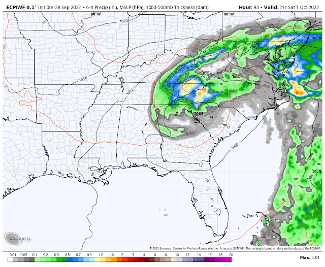
Moving on to the weekend, I think rain from Ian can make it as far north as southern New England by Saturday afternoon...


When it is all said and done, here is a projection showing max wind gusts (not sustained speed) for the whole storm. Notice the winds near SC and GA coast as well....


That's all for now. More to come on my twitter account today @weatherwilly. 


Monday, September 26, 2022

Monday: Hurricane Ian to Slam Into Florida Midweek

Good morning. It has been a while since I have posted but with the winter season approaching the frequency will pick up. In today's discussion we will be focusing on Hurricane Ian which is expected to impact the Tampa area mid week.

Current national hurricane center forecast is below...


Over the past few days, the question has been how far east this track can make it. The European model has been leading the charge here with its consistent track towards Tampa. The American GFS model which was as far west as Louisiana the other day is now more in line with the European. This makes sense to me.

Here is the current wind speed projection of the European along with landfall over Tampa...


At this time it appears this can hit as a Cat 3, maybe a Cat 4 hurricane which would be pretty severe.


In terms of track, I really do not see this going more west, if anything this storm can hit a little further south of Tampa with trends the next few days. I base this on how the hurricane will be influenced by a trough of low pressure off the Atlantic coast. This trough will work to pull the storm more east. The GFS model was not handling this trough properly when it had the storm more west originally...

The above image shows the European ensemble system which looks good to me. The GFS was way too progressive with the trough allowing storm to move more west, a clear error. 

So we have a lot to track next few days. My gut says this hits just south of Tampa. If it does hit Tampa head on, then it would really be a problem as the water would pile up in the bay as storm pushes in.

More to come, stay tuned.