WINTER OUTLOOK 2023 IS NOW LIVE

The 2023 Winter Outlook

Thursday, February 28, 2019

Thursday Update: Light Snow Possible Tomorrow, Larger System Sun-Mon

Good morning. A few rounds of light snow possible tomorrow and Saturday with the potential for a larger storm Sunday into Monday. I do think the larger storm impacts areas more NW however.

Starting off, we will see some light snow move across the region tomorrow morning...


At this time I am thinking a Trace to 1" for NNJ and around 1 maybe a few local 3's for SNJ,CNJ, and Balt/Wash area. Timing is tomorrow morning. Nothing major but it will be a nuisance.

We then will have another weak system impact areas more NW on Saturday morning...


I expect up to another 1" for NW NJ into PA with a narrow band of 2-3 possible across extreme southern New England and potentially Long Island. We will have to watch how this develops.

We then turn our attention to a larger storm system for Sunday night into Monday. At this time I think this storm favors NW of I-95 for a variety of reasons. We will probably end up with some snow changing to rain for areas in green below..


I would expect accumulating snows from NW NJ to Southern New England but the heaviest still to the west of those areas. I can see 2-4" just to the NW of I-95 with 4-8" in the interior from this. 

The reason I am not too bullish on this for areas near the coast is there is nothing to lock in the cold air ahead of the storm. That means we need a perfect track for this to be all snow. The way this winter has gone, I will not give this storm the benefit of the doubt.

I will be watching this closely and have updates.

Monday, February 25, 2019

Monday: Windy Day, Some Shades of Winter This Week

Good morning. It is a very windy day out there. All due to a big pressure gradient as the result of a big storm that moved into Canada seen below...

Gusts can get as high as 45 to 50 mph today from this. The winds die down by later tonight.

The passage of this storm over the weekend brought colder air into the region as well.

As we enter Wednesday afternoon, an upper level disturbance will bring an area of snow into New England and potentially parts of the northern Mid Atlantic...

The exact placement of this still needs to be worked out, but there is a good shot of 3+ inches of snow for Southern New England north.

Temperatures then will warm up next weekend.

After next weekend, a major cold shot looks to hit the area for the first week of March. This will likely be the last major cold shot of the season...


I have given up on this winter a few weeks back so any snow that falls from this point forward is a major bonus imo. At this point I am ready to move on from this winter. It has been very frustrating to say the least. It shows you how the weather is not as random as one may think. We have seen a persistent repetitive pattern this year which as yielded mostly rain and ice. There will be years where the opposite happens and we get a lot of snow. When this winter ends I will investigate what went wrong with my winter forecast. 

Thats all for now. 

Wednesday, February 20, 2019

Morning Update: No Changes

Good morning. No changes to yesterdays thoughts. Cold winter air currently sits over our region. Snow moves in later this morning/early afternoon. The snow lasts a few hours accumulating in most regions before a change to ice. My forecast calls for a general 2-5" of snow. Please look at the range not just the high number. 

For areas NW of I95 surface temps stay below freezing for a good majority of this event. The overall commute this afternoon/evening will be challenged so be careful. 


Current radar shows snow advancing to the southern zones...


Here is an updated timeline:

By 11am light snow should start to get to more northern areas...


By 2pm impacts starts to become noticeable...


By 5pm you can see the ice take over for areas NW of I-95...


In terms of model snowfall outputs, I like the Europeans output...


It also shows that ice accumulation NW of I-95 in pink...

Stay safe out there. Although this isn't a major storm, it will have impacts. Surface temps will be below freezing for a good majority of this event.

Tuesday, February 19, 2019

Evening Update: Winter Storm Tomorrow On Track

A moderate winter storm impacts the region tomorrow. Expect a front end thump of snow to ice and some rain by tomorrow night. There are no changes to my thoughts from this morning.

The video below gives my usual play by play for tomorrows event. The afternoon to evening commute will not be pleasant with this.

Here are the key takeaways:
  • Snow impacts region tomorrow
    • Start times are:
      • Early morning for southern PA, SNJ, Baltimore/Washington area
      • Late morning central NJ, southern NJ, Central PA
      • Lunchtime Northern NJ, Northern PA
      • early afternoon southern New England
  • Snow will accumulate quickly for most across PA into Central to Northern NJ
    • by the early afternoon expect snowfall rates 0.5 to 1" an hr
  • Areas in southern NJ, southern and central DE and harbor areas of MD do not see as much snow with this
  • Snow changes to ice across the interior and rain in southern areas and near the coasts by late tomorrow afternoon into the evening
  • Icing can be a concern for areas NW of I95 tomorrow night
Here is the video:


Tuesday: Winter Storm Impacts Region Tomrorow

Good morning. We will have a winter storm impacting the region tomorrow. Here are the details:


  • Front end thump of snow changing to ice/rain tomorrow into tomorrow night
  • Timing is Wednesday morning for southern areas (Baltimore region) and Wednesday early afternoon for more northern areas (CNJ,NNJ,NY)
  • Expect a decent front end thump of snow from PA into NNJ where a few inches can pile up quick on Wednesday 
  • Snow then changes to ice and plain rain for some
    • Areas NW of I-95 a more prolonged period of ice can occur Wednesday night
  • Expect a messy evening commute tomorrow
    • worth staying off the roads
  • Update 7pm Tonight

Here is my map:


Storm approaches from the SW tomorrow morning...


By Noon, snow is spreading more north...

By the late afternoon snow continues for many and starts to change to ice to the south...


By around dinner time the changeover to ice should occur for most of the region...

Ice lingers into the night for areas NW of I-95...


Storm is sheered off for folks in Southern New England. that is why snowfall amounts are less there.

A stubborn area of dense high pressure is ahead of this storm. This funnels in cold air from Canada...


This will cause cold air to hold on at the surface even though warm air works in aloft. We have seen this situation a few times already this winter. That is why we will have snow changing to ice.

This also can cause snowfall to hold off for a while in NNJ into southern New England as the air will be very dry. This can cut down on totals.


I will have more tonight on this. Stay tuned.

Sunday, February 17, 2019

Sunday: Snow to the North Tomorrow, Ice Midweek

Good morning, a low pressure center will spread snow across northern regions of the forecast area late tonight though tomorrow morning...

I like the output from the European on this (click to make bigger)...


The higher elevations of northern PA and NJ may see a few inches as well with this even though it is not show on the map by tomorrow morning. 

We then have another snow to ice to rain storm for Wednesday...


Few inches of snow may fall for some areas prior to the changeover. Areas near Phili into PA may see a good chunk as precip arrives quicker into the cold air. 

 I will take a look at this more tomorrow. 

Thats all for now. 


Saturday, February 16, 2019

Ice Again Next Week

Some snow/mixed precipitation Sunday night into Monday for northern NJ northward.

Larger storm Wed but looking like another mixing event.

I will have a writeup by tomorow am.

Wednesday, February 13, 2019

More Winter Weather Next Week?

Good morning. An ice storm it was yesterday. Most areas in NNJ  up into southern New England saw about 2-3 inches of snow, sleet and freezing rain combined. In CNJ a little less. The temps really never went above freezing for many. It was our most wintry storm to date.

As we enter the rest of the week, things warm up then cool down again for the weekend.

We then enter a period were winter weather can be active again. There is the shot that waves of energy that can enter the region from Monday though Thursday of next week. Given the pattern I see setting up, I can not rule out snow chances for next week.

I will dive into this more by the end of this week but for now here is a rough sketch of our pattern next week...


Lets see how this plays out.

Tuesday, February 12, 2019

A Cool Look at This Storm


Really cool but short video on how this storm is coming together. Stay safe this evening, temps will not go above freezing for most and the roads are really bad. Sleet and freezing rain continue though the evening. Its currently still in the low to mid 20's in NNJ! Anyone I-78 north stays freezing for rush hour. 

Never mind, just realized video has no audio, oh well. 


Tuesday Morning: No Changes, Storm Moving In

As of 7am the storm is approaching...

Cold dry air is holding off the precipitation for now to the north but that will change. Remember i said this would happen yesterday. Within a few hrs snow moves in and changes to ice.

Forecast is on track...

Stay safe, roads will deteriorate as we get towards late morning. 

More details in my post below from last night.

Monday, February 11, 2019

5pm Update: Final Forecast, Video Out Around 7pm


Final forecast map below.

Video Update:


  • Snow starts early tomorrow morning just before daybreak in CNJ/PA and around or just after daybreak NNJ
    • Areas in NNJ may not see it start till after you wake up
    • SNJ and surrounding areas mostly rain with this
  • Snow will quickly change to freezing rain and sleet by mid to late morning
    • For CNJ surface temps will get above freezing around early afternoon
    • For NNJ into Southern New England surface temps stay below freezing till mid afternoon
    • most accumulations are from sleet not snow**
  • Biggest concern is ice not snow with this system
    • expect a quick burst of snow in the morning then sleet to freezing rain to plain rain to end by middle of the afternoon
    • snowfall totals include sleet
  • Road conditions deteriorate south to north from 7-1030am


Monday Morning Update: No Changes From Yesterday, Some Additional Thoughts

Please read my post from yesterday. I broke down tonight into tomorrow's storm and gave a bullet point timeline for what to expect. I do not have any changes to those thoughts this morning. 

I want to make a point that its not the snowfall I am worried about with this storm. If fact, do not be surprised if you see the lower end of my totals in some areas. However, that is not the concern with this storm. The concern is ice given that surface temps stay below freezing for most areas (outside of light blue and green) till at least 12 pm tomorrow. That means a mess of sleet, freezing rain and snow by tomorrow morning. That is what will cause the impacts.

The storm starts from SW to NE late Monday night. Areas in NNJ and southern New England may not see the storm start till after daybreak Tuesday due to dry cold air in place ahead of it. Impacts will move in rapidly after that so do not be fooled. 

I will have a video out tonight and tweak my map to show less snow and more ice.


Sunday, February 10, 2019

Sunday Afternoon: Winter Storm Impacts Region Tuesday

Good afternoon. A winter storm will impact the region Monday night into Tuesday morning. Although the whole storm will not be snow, there will be impacts for many areas Tuesday morning due to the timing of the precipitation. Beforehand, a light snow event hits some areas tonight. 

Summary:


  • Light snow tonight for southern areas
    • 1-2" locally 3  for Central and South Jersey
  • Main storm arrives Monday night
    • Snow overspreads most areas and starts to accumulate after midnight for most
  • By Tuesday morning
    • Snow changes to rain for southern areas
    • Snow changes to ice for CNJ
    • Snow holds on for NNJ into New England
  • By Tuesday late morning
    • Snow changes to Ice for NNJ into southern New England
  • By Tuesday Afternoon
    • Rain to end for most areas ex New England
When its all said and done expect 1-2" for areas south, 2-4 inches to sleet and freezing rain for the bulk of forecast area, and 4-8" across the interior and New England. Tuesday morning will not be a good travel period. Expect cancellations and delays. 
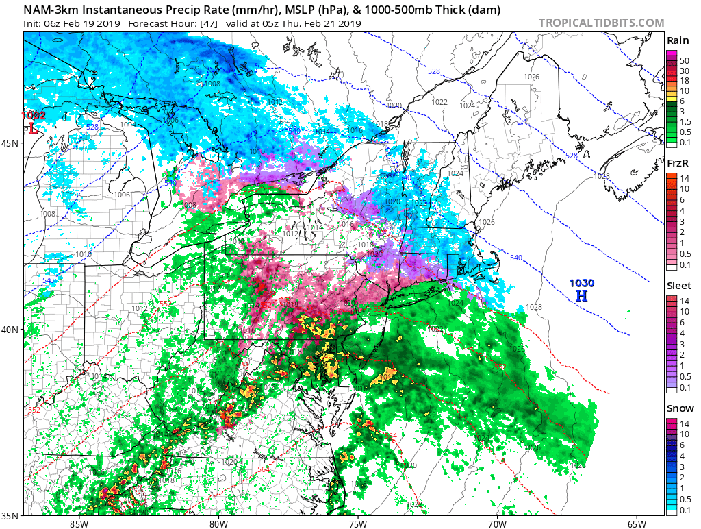
Here is my map:


Highest impacts are in pink and darker blue zones. For light blue there will be impacts Tuesday morning but rain should take over by mid morning. 

So lets take a look at things.

Tonight light snow moves into the area. This is nothing major but will cause some travel headaches for southern areas tomorrow morning....

The 3 inch amounts seen above may be a little high but regardless expect impacts tomorrow morning in this area.

Then we move on to the main event...

Low pressure moves in from the west on Monday night. We will have a high pressure center to our north that will help reinforce cold air ahead of it, especially at the surface...


It is because of this cold high that we will have region wide impacts with this storm. The result is surface temps staying below freezing for most for the duration of Tuesday morning. This is despite the fact warm air will work in aloft. Models have trended stronger with this high compared to earlier this week. 

You can see the warm air move in aloft changing snow to ice Tuesday morning...


The surface cold air holds firm however for at least the 1st half of the morning...


This means sleet and freezing rain for many! I am confident this cold air holds on.

By the afternoon rain will move in but notice ice holds on for many in Southern New England and NNJ..


Across the far north a heavy snowstorm is underway.


Thats all for now. I will have an update in the am.


Update This Afternoon

I will issue a breakdown of what to expect for tonight's light snow and Tuesday mornings winter event (snow to ice to rain). The timing of both events can cause impacts.

Stay tuned.

Friday, February 8, 2019

Friday: A Closer Look at Next Weeks Storm

Good morning. Even though rain will be the main theme for most, I figured I would take a closer look at next week.

Rain ends today and cold air moves in the for the weekend...


Expect highs in the low to mid 30's and lows in the high teens to lower 20s this weekend.

We then have the chance of some light snow on Sunday night into Monday as a weak upper level disturbance moves through the area...

If this materializes a general 1-2 inches can fall but some models have it more broken up.

The main storm then approaches on Tuesday morning. This is where any winter precipitation will change to rain after a few hours of snow/ice for everyone outside of interior New England...


Given there will be some cold air ahead of this storm, we can not rule out a few quick inches for our northern areas (NNJ,PA, southern New England) before a changeover.

I will keep an eye on this but it appears to be a similar set up to many other storms we have seen this year- quick round of snow changing over to ice and rain. 

We then may be entering a more favorable pattern as we head to next weekend for snow. I discussed this yesterday.

Stay tuned. 

Thursday, February 7, 2019

Thursday: This Winters a Broken Record, Rain Next Week, Maybe Winter After

I was skeptical and now I know why. The pattern just is not right for snow in the northeast next week...


All these areas circled are opposite of what they should be in terms of a pressure pattern. Low pressure near Greenland, low pressure on the west coast and high pressure along the east coast. This screams rainstorm. I never bought the models that showed a big snowstorm days ago because of this pattern. I am glad I didn't.

Even though it gets cold this weekend, this storm will develop to our west Tuesday and by Wednesday drive up the warm air...


Why fight this? It has been the trend ALL winter! Maybe northern New England can luck out.

Following this, models are trying to suggest the pattern may get a little more favorable for snow by next weekend with high pressure or a -NAO pattern developing over Greenland...


When this pattern of high pressure over Greenland develops it aids in locking in cold air ahead of storms in the east and also consolidating energy. Most big winter storms all see this pattern and we have yet to see it yet this year.

As an example, remember how active March got last year with all that snow? Look at the pattern over Greenland for this period...


Such a critical piece to get winter storms.

Now a factor that can support this pattern developing is thunderstorms in the tropics going into a favorable position near Africa over the next 6-10 days...


This pattern called the MJO when in this phase tends to produce this...


So we do have some hope for a colder and snowier pattern to develop in the east by next weekend.

I just am just skeptical due to how this winter has gone so far.

Lets see what happens. 

Wednesday, February 6, 2019

Update Tomorrow

Winter can return next week. I am still skeptical but I will explain tomorrow morning.

Stay tuned.

Monday, February 4, 2019

Monday: Spring Like Warm up This Week, Storminess Can Return After

Good morning. Early springlike temps, that will be the theme of this week in the eastern US.

Pacific energy is flooding in which mean temps go into the 50's and 60s for many areas throughout the week...

There will be a few episodes of rain with this mild pattern especially Wednesday night into Thursday...


A cold front finally then passes through the area on Saturday bringing with it a return to winter like temps...


Then we will be entering a 10-15 day peroxide where there will be the chance at more winter type events. The jury is still out on this and we will have to see how things evolve.

I mentioned on twitter that this winter has not panned out as forecasted. Sure we have had impressive cold episodes but no real snowstorms or even moderate snow events for many along the I-95. For a snow lover, the best we can hope for at this time is one good storm before the middle of March.

This 10-15 day period will be our first window for that to happen...


Cold air should be driving into the country as seen above and storms will try to form along the gradient between warm air in the southeast and cold air to the northwest. The key however will be if we can get any blocking or high pressure to form over Greenland. If we do then its game on.

More to come, enjoy the spring week.