WINTER OUTLOOK 2023 IS NOW LIVE

The 2023 Winter Outlook

Saturday, January 27, 2024

Saturday: Northern Snow Event Tomrorow

 Haven't commented much bc its out of the Tri State but here is my forecast for tomorrow below. The highlands of NW NJ can see some snow from this but rain to start. True winter doesn't return till around Valentines Day. From there we prob have a 4 week run at winter weather before the season is over. 


Thursday, January 18, 2024

Final Forecast for Tomorrow

 Good evening.  I made some changes and below is my final forecast for tomorrow. I cut down amounts across the north and honed in on the zone of heaviest snow. Snow starts in early morning and lasts all day light to moderate at times. Expect temperatures to be very cold. Overall it will be a classic mid winter snowy day.


 I will have a quick update out in the am. There's a twitter video I just cut you can find on the right hand side of this webpage. 


Thursday Morning Update: Moderate Snow Event on Track for Friday

 Good morning. Our moderate snow event is still on track for Friday. Timing is Friday morning through the evening. It looks like the heavier precipitation will arrive around 10-11am tomorrow morning. This setup still has a high degree of volatility meaning we can see last min shift up to the time of the event with the narrow heavier band of snow. I am keeping my forecast from yesterday and I do not have any overwhelming data to change it. I will have a final update at 9pm tonight. It is my best estimate of where this heavy snow can set up at this time. 


Lets take a loo at the expected evolution. This storm involves an initial batch of energy that will move offshore early Friday, then a trailing arctic wave that will try to capture part of it causing an extended period of snow for the daytime Friday. These capture situation are very hard to nail down...


Light snow should be in the area around daybreak tomorrow...


By time we approach afternoon it is snowing decent in most areas...


Around 7pm things should start to taper down...


Models are still spread in their precipitation outputs but a good middle ground is what the NAM model has...


Given it will be very cold across northern zones during this event add an inch or two to the amounts to account for higher snow ratios. 


Very cold air then settles in for the weekend.


Stay tuned final update tonight around 9pm. 

Wednesday, January 17, 2024

Wednesday Update: Initial Idea for Friday Snow Chances

 Good morning. Below is my initial estimate for impacts from snow on Friday morning. Very high volatility forecast so things can change. I tried to anticipate where this may trend. Stay tuned I will have a video update out tonight on this. 


Monday, January 15, 2024

Monday Update: On Track, Nice Moderate Snow Event Tonight

Good morning. Here is my final forecast below. Overall this is turning out to be a nice moderate snow event on tap. Timing is late tonight into tomorrow morning.


The GFS model is finally picking up on what I thought would happen with this system.


Big changes from what these models showed yesterday. They always tend to underestimate amplification of these storms in situations like this. 


Storm should be over for most around noon time with very cold air in its wake. We then still have to watch next weekend for something bigger to develop. I am not sold yet, but the threat is there!

Sunday, January 14, 2024

Sunday Update: Moderate Snow Event Tuesday

 Good morning. Although it will not be major (originally thought it could be), data is supporting the shot at a moderate snow event late Monday night into early Tuesday afternoon. Below is my initial forecast map. I will share more details in next 24 hours.


Friday, January 12, 2024

Friday Update: I Am Gaining Confidence in Major Winter Storm Tuesday

 Good morning. Still far out as always, but I am gaining confidence this storm on Tuesday hits. I cut a video last night below that discusses my thoughts. More to come. 


Friday, January 5, 2024

Friday Night Update: Storm on Track, Will Come in Fast Tomorrow Afternoon

 Good evening. My forecast is on track for tomorrow winter storm. The biggest development today is the arrival of the snowfall coming in earlier. This means snow can pile up fast across the tri state by late tomorrow afternoon. The video below is a quick breakdown of my concern. No changes to my accumulation map.


Friday Update: Winter Storm on Track to Impact the Region

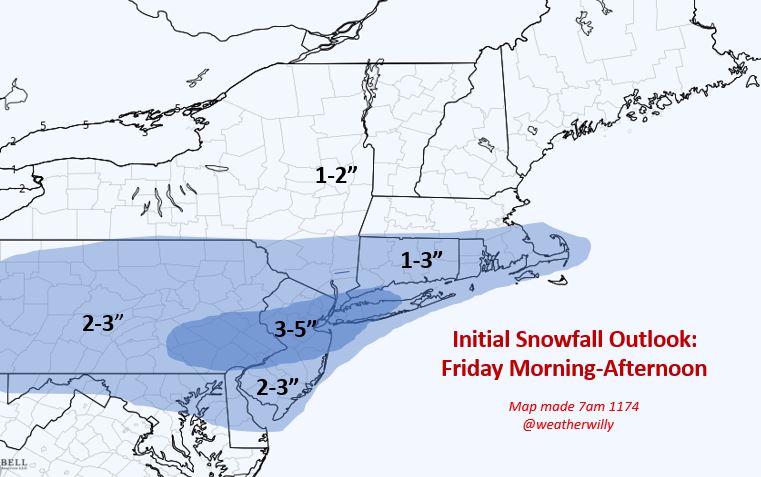
Good morning. I am making to changes to my going forecast from yesterday. A winter storm is expected to impact folks who live NW of Interstate 95 late Saturday afternoon into early Sunday morning. For areas in NNJ, this will be very elevation dependent for higher snowfall totals. My map tries to reflect that.  I will have another update out tonight around 10pm.

Lets take a look...

The forecast...


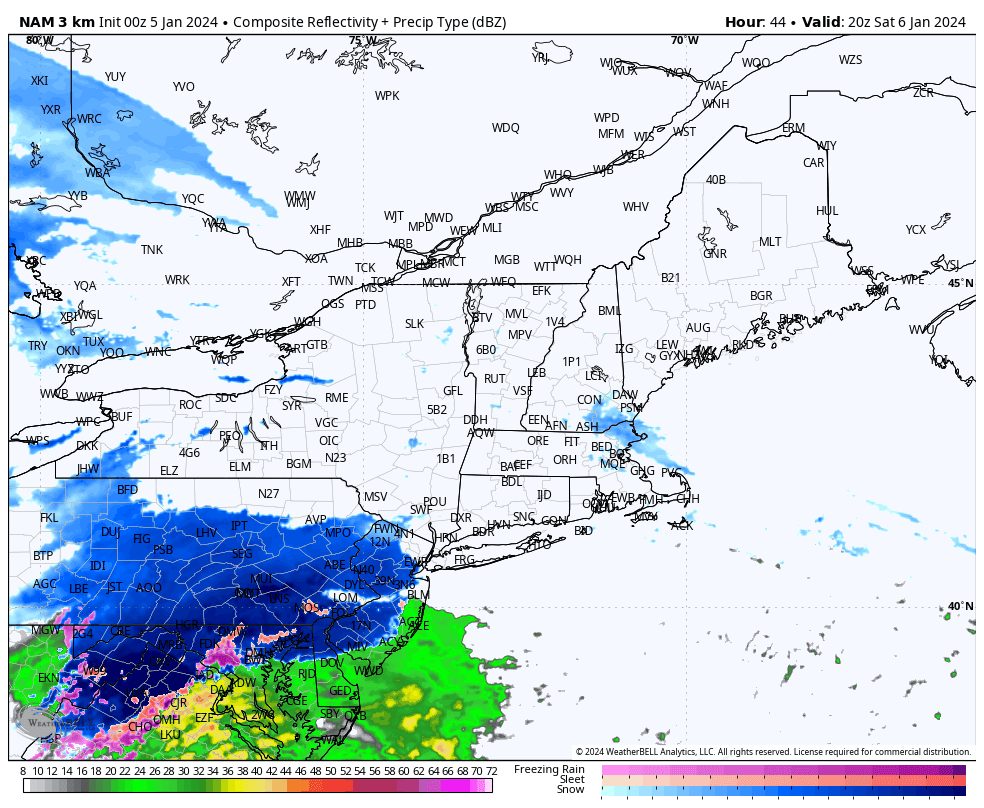
Lets look at updated model guidance to review the evolution of the storm...


Snow should start to spread into the region by mid afternoon Saturday. Most areas north of Princeton should start as snow...


As the storm continues to move in, warm air is brought with it changing any snow to rain for most along I-95 by mid evening...


By the time we get just before daybreak on Sunday, the storm is ending in areas like NJ and still lingering in southern New England..


When its all said and done this will be a decent snowstorm for some and a rainy mess for others. Here is a blend of models snowfall foreacst...


Notice the cutoff in heavy snow where the mountains are in NW NJ etc. For most in tristate is this just a nuisance. 


The reason why this is not a more widespread snowstorm is due to HP to our north sliding east. This allows more warm air to move in. Notice the red high below off the Atlantic coast. 


For snow to make it to 95 you need this to be more reinforced.

Stay tuned. More updates to come.

Thursday, January 4, 2024

Thursday: Updated Snowfall Forecast

Good morning. Below is my updated snowfall forecast for this weekend's storm. I will have an updated breakdown of the storm out tonight around 8pm. Overall everything is on track. Stay tuned!


Wednesday, January 3, 2024

Wednesday Storm Update: Updated Forecast for Saturday Night-Sunday

 Good morning. Below is my updated forecast map for the expected winter storm Saturday night into Sunday. This is my best initial estimate on what to expect. Nothing is ever a lock this far out but I do my best to try to make a forecast on where things may be trending.


The trends over the last 24 hours have been to weaken the storm vs yesterday. At this time folks in darkest shaded zone should expect a moderate snowfall starting just after dusk on Saturday night and ending Sunday morning.

There is no one model at this time that shows the storm evolving exactly as you see above but I will show the European as an example.

Storm still expected to move in after dusk on Saturday...


As the night goes on it really starts picking up in intensity...


The model above is overdone with the heavy snow that far south in my opinion. This should stay heaviest NW of I-78. 

By Sunday morning the storm is over.

Trends over the last 24 hours have been to weaken the storm seen below. This means no widespread amounts near a foot. It also means some colder air can stay around for areas near NYC which allows for some minor accumulations...


Stay tuned, many updates to come. Video tonight at 8pm.

Tuesday, January 2, 2024

Tuesday Update: Winter Storm on Track for Saturday Night-Sunday

 Good morning. Our regions first widespread winter storm will impact the area on Saturday night. Below is my initial estimate of impacts from this system. Overall, anyone NW-I95 should see a decent snowstorm out of this. Just to the south and east snow is expected, but not as heavy and may mix with rain.

Timing is Saturday night late into Sunday morning.


Here is my initial impact map..


Right now the European model has the best general idea of how I think this evolves...


Storm moves in Saturday night...


By early Sunday morning its cracking with heavy snow NW of I-95...


By mid morning Sunday its starting to taper off...


Again this is just my initial estimate and is subject to change. Stay tuned for daily updates and many videos to come breaking down the storm!