Good morning. I am making to changes to my going forecast from yesterday. A winter storm is expected to impact folks who live NW of Interstate 95 late Saturday afternoon into early Sunday morning. For areas in NNJ, this will be very elevation dependent for higher snowfall totals. My map tries to reflect that. I will have another update out tonight around 10pm.
Lets take a look...
The forecast...

Lets look at updated model guidance to review the evolution of the storm...
Snow should start to spread into the region by mid afternoon Saturday. Most areas north of Princeton should start as snow...
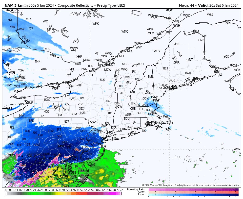
As the storm continues to move in, warm air is brought with it changing any snow to rain for most along I-95 by mid evening...

By the time we get just before daybreak on Sunday, the storm is ending in areas like NJ and still lingering in southern New England..

When its all said and done this will be a decent snowstorm for some and a rainy mess for others. Here is a blend of models snowfall foreacst...

Notice the cutoff in heavy snow where the mountains are in NW NJ etc. For most in tristate is this just a nuisance.
The reason why this is not a more widespread snowstorm is due to HP to our north sliding east. This allows more warm air to move in. Notice the red high below off the Atlantic coast.

For snow to make it to 95 you need this to be more reinforced.
Stay tuned. More updates to come.
Full send! Praise be to God. Whats the loaf gonna get weather willy?!?!
ReplyDeletefew inches maybe.. not the storm for Maine as the heaviest precip will stay south.
DeleteYou can achieve your dreams by being a member of the Great ILLUMINATI brother hood. With this all your dreams and heart desire can be fully accomplish, if you really want to be a member of the great Illuminati brotherhood, Note: newly recruited members are entitled with 600,000 US Dollars , A Ring, that will protect and guild you from enemies, and a visa . Warning only contact us if you're interested. Kindly contact via whatsapp:+905488400195
ReplyDeleteemail: illuminatihood6666@hotmail.com
श्रीकामकलाकालीसहस्रनामस्तोत्रम् ॥ श्रीकामकलाकालीसहस्रनामस्तोत्रम् ॥ ॥ देव्युवाच ॥ त्वत्तः श्रुतं मया नाथ देव देव जगत्पते । देव्याः कामकलाकाल्या विधानं सिद्धिदायकम् ॥ १ ॥ त्रैलोक्यविजयस्यापि विशेषेण श्रुतो मया । तत्प्रसङ्गेन चान्यासां मन्त्रध्याने तथा श्रुते ॥ २ ॥ इदानीं जायते नाथ शुश्रुषा मम भूयसी । नाम्नां सहस्रे त्रिविधमहापापौघहारिणि ॥ ३ ॥ श्रुतेन येन देवेश धन्या स्यां भाग्यवत्यपि ।… Read More “ह्रीं श्रीराधायै स्वाहा” श्रीराधा-उपासना – देवी भागवत अनुसार ॥ ह्रीं श्रीराधायै स्वाहा ॥ श्रीराधा-उपासना – देवी भागवत अनुसार भगवान् नारायण कहते हैं — नारद ! सुनो, यह वेदवर्णित रहस्य तुम्हें बताता हूँ । यह सर्वोत्तम एवं परात्पर साररहस्य जिस किसी के सम्मुख नहीं कहना चाहिये । इस रहस्य को सुनकर दूसरों से कहना उचित नहीं है; क्योंकि यह अत्यन्त गुह्य रहस्य है ।… Read More गुह्यकाली संजीवन स्तोत्रम् ॥ अथ गुह्यकाली संजीवन स्तोत्रम् ॥ इस स्तोत्र को पढ़े बिना गुह्यकाली सहस्रनाम पठन का पूरा फल नहीं मिलता । अत: इस स्तोत्र का पाठ अवश्य करें । ॥ महाकाल उवाच ॥ इदं स्तोत्रं पुरा देव्या त्रिपुरघ्नाय कीर्तितम् । त्रिपुरघ्नोऽपि मां प्रादादुपदिश्य मनुं प्रिये ॥ १ ॥ गद्याकारं च स विभुः स्तोत्रं तस्यै चकार ह… Read More गुह्यकाली सहस्रनाम स्तोत्रम् ॥ अथ गुह्यकाली सहस्रनाम स्तोत्रम् ॥ ॥ पूर्वपीठिका ॥ ॥ देव्युवाच ॥ यदुक्तं भवता पूर्वं प्राणेश करुणावशात् ॥ १ ॥ नाम्नां सहस्रं देव्यास्तु तदिदानीं वदप्रभो । ॥ श्री महाकालोवाच ॥ अतिप्रीतोऽस्मि देवेशि तवाहं वचसामुना ॥ २ ॥ सहस्रनामस्तोत्रं यत् सर्वेषामुत्तमोत्तमम् । सुगोपितं यद्यपि स्यात् कथयिष्ये तथापि ते ॥ ३ ॥ देव्याः सहस्रनामाख्यं स्तोत्रं पापौघमर्दनम् ।… Read More गोपिका विरह गीत ॥ गोपिका विरह गीत ॥ एहि मुरारे कुजविहारे एहि प्रणतजनबन्धो । हे माधव मधुमथन वरेण्य केशव करुणासिन्धो । (ध्रुवपदम्) रासनिकुञ्जे गुञ्जति नियतं भ्रमरशतं किल कान्त । एहि निभृतपथपान्थ । त्वामिह याचे दर्शनदानं हे मधुसूदन शान्त ॥ १ ॥… Read More श्रीयुगलकिशोराष्टक ॥ श्रीयुगलकिशोराष्टक ॥ श्रीरूपगोस्वामीजी द्वारा रचित श्रीयुगलकिशोराष्टक श्री रूप गोस्वामी (१४९३ – ameya jaywant narvekar १५६४), वृंदावन में चैतन्य महाप्रभु द्वारा भेजे गए छः षण्गोस्वामी में से एक थे। वे कवि, गुरु और दार्शनिक थे। वे सनातन गोस्वामी के भाई थे। इनका जन्म १४९३ ई (तदनुसार १४१५ शक.सं.) को हुआ था। इन्होंने २२ वर्ष की आयु में गृहस्थाश्रम… Read More राधामाधव प्रातः स्तवराज ॥ राधामाधव प्रातः स्तवराज ॥ प्रातः स्मरामि युगकेलिरसाभिषिक्तं वृन्दावनं सुरमणीयमुदारवृक्षम् । सौरीप्रवाहवृतमात्मगुणप्रकाशं ADD
ReplyDelete