WINTER OUTLOOK 2023 IS NOW LIVE

The 2023 Winter Outlook

Wednesday, December 21, 2022

Wednesday Storm Update: Rain Moves in Thursday Night, High Winds, Crashing Temps to Follow

 Good morning. The storm system we discussed will be entering our area on Thursday night. Expect a period of rain and gusty winds followed by crashing temperatures and potential back end snow showers by late Friday morning. Temperatures will go from being in the 40's and 50's during the storm to single digits for some areas by Friday! Winds will really be gusting by tomorrow night so be prepared for this.

Lets take a quick look. Below is the updated evolution of this storm from Thursday night into Friday afternoon...


You can see the heavy rain move in by tomorrow night then notice the cold air and potential snow showers come in at the end.

Look at how much temperatures crash by Friday morning...


This is a true arctic cold front.

In terms of wind, models always overdo wind gusts so take 60% of these numbers. Very high still..


Things then stay cold through Christmas. We need to watch around the 28th for our next storm threat. Stay tuned. 

Monday, December 19, 2022

Monday Update: Big Blizzard Hits Midwest, Rain to Ice to Bitter Cold for Northeast by Sat

Good morning. Over the last several days a lot has changed with the weather. What originally looked like it could be a big east coast storm for later this week has trended west into a mid-west blizzard for Thursday and Friday. Our region will be on the warm side of this storm which means rain on Friday followed by high winds and very bitter cold temps by Christmas Eve morning as an arctic front crashes in on the backend of this storm. Snow is also not out of the cards on the backend of this storm early Saturday morning. 

Lets take a look...

All models now have a big storm projected for Midwest Thursday and Friday..


As you can see above an intense blizzard heads towards Chicago 
with high winds and heavy snowfall rates. To the east notice the sweeping rains that come into our area on late Thursday night into Friday.


Here's where this still does get interesting. There is true arctic air on the back of this storm. I am talking about sub zero to single digit temperatures. That air crashes towards the east coast on Friday night...


As this arctic front moves in winds are really going to pick up...


Be prepared for this on Friday night. We may see some power outages.

If the orientation of this storm and the arrival of the cold air are in the right alignment. We can see backend snow with this system. To early to pinpoint where, but the threat is there for a wintery end to this storm by Saturday morning...


Bitter cold temps follow for Christmas eve and Day. Bundle up!

Stay tuned. 

Thursday, December 15, 2022

Thursday: Final Forecast for Today's Storm

Good morning. Below is my final forecast for the storm that will impact the region this afternoon into Friday. For most not to the NW in elevated locations this is rain. However, if you are in the pink zone in, expect impacts by later this afternoon (start time ~1-3pm). I will share an update later this afternoon as this gets underway. 


Here is updated forecast...


You can see how NW NJ into western CT etc is in pink. This is where I expect an initial burst of snow and then some frozen precipitation later this afternoon into tonight. I think there are going to be more travel impacts in this pink zone that most expect. Elevation will play a major role (folks above 800ft). 

Here is a play by play: I am using the GFS model because I think it shows the evolution the best. 

In terms of timing, most models start the precipitation by early this afternoon say between 12 to 2pm...


By mid afternoon and especially this evening, I expect impacts to start mounting on the roads in the pink zone on my map. Models are still spread on how much cold air holds on and I am in the camp frozen precipitation falls longer than expected.


By 7pm warm air will try to change snow and ice to rain but this is the critical period....


A small 15 mile adjustment will have big implications but as you can see this model shows my concern that snow/frozen precip continues into NW NJ.


Eventually warm air does win out and things should change to plain rain for the whole pink zone, but that may not be till late tonight into Friday morning...


As you can see a snowstorm continues into the far interior. The storm then ends by Friday early afternoon.


Wednesday, December 14, 2022

Wednesday: Updated Forecast for Thurs-Fri Storm System

Good morning. A major storm will impact the area from Thursday morning until Friday evening. Heavy snow will fall across the interior with mixed precipitation then plain rain as you head towards the coasts. Below is a summary and my updated forecast map.

I will have an 8pm update out tonight with final details. Be sure to check in. 

Summary:

  • A big storm system approaches the area Thursday morning.
  • Initially it will be cold enough in areas NW of I-95 to cause frozen precipitation by late Thursday morning early Thursday afternoon
    • Do not be surprised to see a thump of snow the more NW from 95 you go Thursday early afternoon which can cause a few inches to pile up quick before a changeover
    • This is most difficult part of forecast but I am a little more bullish than most on this occurring. 
    • The dark pink zone is this risk
  • This precipitation will eventually change to ice then plain rain for most areas
  • Areas like NW NJ and Western CT can see a few inches of snow pile up before the changeover making the roads not in ideal shape
  • The storm will end by Friday evening 
Here is my updated forecast map:


I tried to hone in as much as I could for impacts. The light pink and green zones I do not expect major impacts from this. Just could be a icy start but will change to rain. For the dark pink this storm can start quite wintery in nature with a burst of heavy snow and ice. A few inches can pile up quickly by Thursday afternoon before a changeover. For the interior this is an old fashioned major snow storm.

Looking at the models, there still is a spread with how much cold air can make it south initially.

The coldest model is the GFS which has the snow coming closer to the coast Thursday afternoon...


Warm air then tries to work in aloft causing the snow to change over. The GFS however is holding on to cold air closer to the coast. We need to keep an eye on this. I have seen situations like this be colder than modeled before and the GFS may be on to something...


Other models are more north with the snow for Thursday night...


The key is going to be how far east the low develops off the coast and how much cold air can dam or hang in over our area in the meantime...


Models will still make adjustments to this today. 

Stay tuned for 8pm Update.

Tuesday, December 13, 2022

Initial Forecast Idea for Thurs-Fri

Good morning. Below is my first forecast for Thursday afternoon to Friday. For pink zones I expect a front end thump of snow possibly several inches before a changeover to ice then some light rain. Stay tuned I will share much more detail tonight at 8pm. 


Monday, December 12, 2022

Monday Update: Still Eyeing Thurs-Friday Storm System

Good morning. It was a nice snowfall for many areas yesterday that saw their first taste of winter! Our focus now turns to a bigger storm later this week. As of now, I still think areas like NW NJ, NEPA,NW CT can get in on this storm in terms of frozen precipitation. The video below outlines my thoughts. More to come...


Saturday, December 10, 2022

Saturday Update: Nusiance Snow Event Tomorrow, Major Storm Later Next Week

Good morning. Many areas off the coasts will see their first snowfall tomorrow. For most it is more of a nuisance event , but some areas will see several inches. This will be very elevation dependent. Our eyes then turn to a major storm that will impact the region and the end of next week. Winter weather will be in the cards for some. 

Summary:

  • A light to moderate snow event impacts the interior Sunday
    • mostly a nuisance with some moderate accumulations over the mountains
  • All eyes then point for a potential major storm later next week
    • Focus looks to be off the coasts NW of I-95 for winter weather
    • Big potential with this system
  • Our pattern change has arrived. There will be colder than normal temps and multiple shots at snow through Christmas this year. 

Starting off here is my updated forecast for tomorrow...


Outside the darkest zone, this is a nuisance event. If you do not live in an elevated location, there is not much to worry about with this system. Rain will fall in areas not shaded to the south. Timing is tomorrow mid morning into the evening. 

Moving on, we have a potential major storm to track for the end of next week. The atmosphere is setting up something known as a blocking pattern. This mean energy gets clogged up under high pressure along the eastern seaboard. With cold air to work with this time, there is a good chance for snow off the coasts.

Lets take a look...

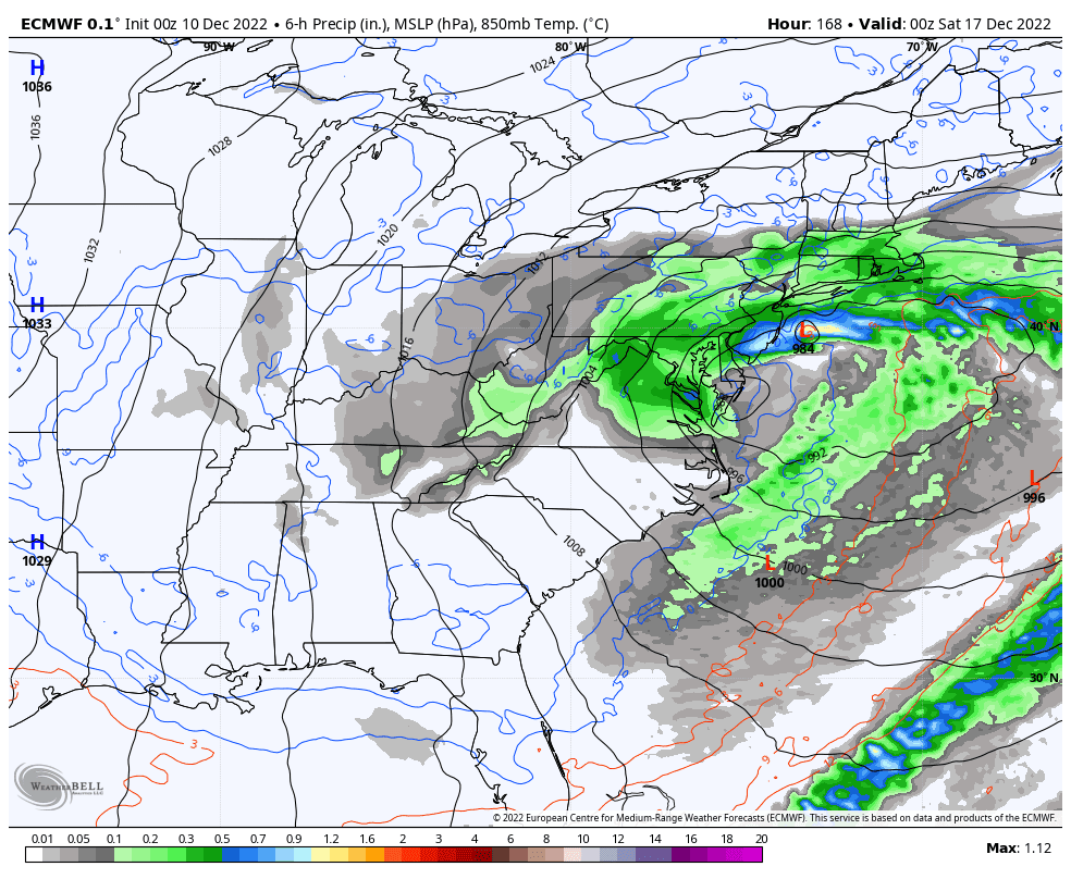
A big storm forms over the west early to middle of next week...


Normally this would cut into Canada, surge in warm air and eventually rain into our area. However, there is a massive block or high pressure sitting to its north. This will force the storm to stop and reorganize itself over the eastern seaboard. Below shows this blocking pattern...


This is a very uniquie pattern we do see often in December. When there is this much high pressure to our north, and the the mild air is also blocked off from the pacific, storms can slow down and blow up near eastern seaboard.

The european model is the most agressive with this system and does exactly this on Friday and Saturday..


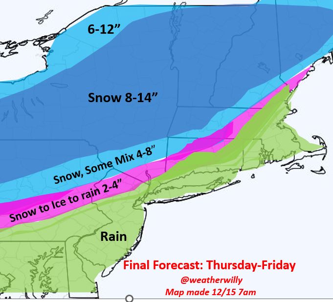
Think of it as the storm energy that gets blocked to our west "slides" under the high pressure system then restrengthens off the coast. That was what you are seeing above. The key is going to be the exact placement of this. As of now I like the idea of a potential major snowfall for areas NW of I-95 especially into PA, NY State and interior New England. There will be mixing issues the closer you get to the coast.

If this system misses us it wont be missing north it will be missing to the south if the block ends up being too strong. That is what the GFS shows...


This seems wrong to me. I do not trust the GFS lately in the long range. It gets much better in the short range (model was just upgraded and showring some issues). 

Now heres the key. What fits the pattern? A few days ago models where cutting this storm into the lakes. Now all of a sudden they are turning it into a coastal storm. This is simply the model adjusting to the pattern, not the other way around. As the function of time decreases, the model figures out what should happen given a patern like this. Below shows the adjustment in the GFS model over last several days. Pretty extreme, notice how it adjusts the storm track as it figures out there is a block to the north. This is a good lesson in long range forecasting. The models usually adjust to the pattern not the other way around.


So bottom line is this, Major potential is on the table for end of next week and the period to follow through Christmas, which can feature more storm threats. The pattern change discussed has arrived and it really can deliver a December we haven't seen in a decade. Stay tuned. 


Thursday, December 8, 2022

Thursday: Some Snow Spreads into Region Sunday

 Good morning. We are still about a week away from our pattern change I discussed but that is not stopping the weather from doing what it wants. A weak to moderate storm system is going to approach the region from the west on Sunday and spread accumulating snow into areas off the coast to the NW. The timing will be mid morning Sunday to Sunday night. Below is my first estimate of impacts and is subject to change over next few days...


As you can see the focus is off the coasts for any accumulations. As of now, here is the model I think that is handling this system the best, the GFS model...

Snow spreads into some areas Sunday morning...


Notice the focus over the I-80 corridor.

By the mid afternoon it is snowing across the interior...


Snow then tries to work its way south as storm pulls away Sunday night...


At this time I do not think this makes it too much further south. I think the Poconos, Catskills are the bullseye for the system with some light accumulations elsewhere.

We then start our transition next week to a true winter pattern. A storm system cuts to our west Thursday redevelops over the east giving interior New England snow...


This storm will usher in the pattern change and we then need to look for snow closer to the coasts through the end of the month. Stay tuned. 

Wednesday, December 7, 2022

Wednesday Update: Honing in on Details

Good morning. The pattern is in the process of changing as we enter next week. A small storm system hits central PA with snow Friday night then another system may spread snow further east over NY state and interior New England Sunday. A bigger storm then approaches middle of next week with mixed precipitation for New England. It is this storm that will lock in the pattern change. I expect the period to follow to lock in winter in the eastern 1/3 through end of December. 

In terms of the imitate impacts for this weekend's storm systems. I will comment more later. The wave of low pressure forecasting to move into the area Sunday can throw a few surprises. Enjoy the mild rainy weather by this time next week we will be in a much different arena. 

Stay tuned.  

Monday, December 5, 2022

Monday Dec 5th: 10th to 20th Period on Track

 I continue to view the 10th to 20th time period as a step down to winter weather for the northern Mid-Atlantic into New England. This means the shot at at least 1 snow event for areas off the immediate coasts. For areas on the coast the best chance will be later this month as the oceans are still very warm and make it harder for it to snow.  Regardless, a very active period is on tap and it has  a similar look to some great Decembers of the last two decades. 

Models have still been trying to sort out details on this period but I like what I see. We have a major block in the jet stream that is modeled to develop an strengthen. This means any storm energy that moves towards our region will get "clogged up" and have some cold air to play with. 

In terms of this week, a storm system approaches from the west on Friday night and should hit the I-80 corridor in PA with a nice band of snow before fizzling out when it gets towards NJ. I am still keeping a close eye on this, but the Canadian model makes the most sense to me...


Most models have this fizzling out by the time it gets into NJ. This can def happen as it is running into a dry airmass. The Canadian has some lingering snow still make in it...


This is prob overdone and I would say that as of now the chance of light snow for areas in NW NJ Saturday Morning. 

The block I discussed then takes hold next week...


That red blob over Hudson bay and western Greenland can cause all sorts of mischief as storms undercut it (blue shades). We need to watch middle of next week for something to spin up along the eastern seaboard.

This pattern then should continue into the 3rd week of December. 

Stay tuned will have more details as things evolve. 

Tuesday, November 29, 2022

Tuesday Nov 29th: Big Flip to Winter in 10 Days

 Good morning. What has seemed like a tame weather pattern in recent days will made a pretty big flip by the time we get from the Dec 10th to 20th time period. I expect winter to arrive pretty abruptly with a step down to cold and yes possibly snowy conditions. There are many factors in the atmosphere evolving right now to support this that I have been watching evolve carefully over the last two weeks. Today I will discuss some of these.

Starting off, my going forecast idea is that by Dec 10th the northeast enters a a wintery period of weather. This means colder than normal conditions with the chance of a snow event between the 10th and 20th timeframe. Prior to this occurring, things should stay seasonable with the chance of a few light rain events. Do not be fooled however, there are things evolving right now that we have not seen in recent Decembers.

Starting off, going way up into the atmosphere at the stratosphere, the polar vortex has been weakened in recent weeks. What does this mean? Normally when you have a tight wound up PV, it locks all the cold air up in the pole and its mild across our area. When the PV becomes stressed and is not able to strengthen, you start to see some of that cold air pour south. 

The image below shows the current PV. Notice how it is off its center axis and pushed south closer to our side of the globe in blue...


As we move further down in the atmosphere, we are seeing other factors emerge that are also putting stress on this vortex while setting up a pattern for stormy weather by week 2 of December...


Looking at the image above sums up what is projected to occur. Red areas are high pressure and warm air, blue are lower pressures and colder air. What is happening over Greenland is quite signifigant. That big red blob is called a blocking pattern. This means it causes the jet stream to buckle over our area allowing storm energy to consolidate near the east coast. We have not seen a projected pattern like this since December 2009. If this verifies, it will mean the chances for winter winter significantly increase by week 2 of Dec. 

In my opinion what is occurring is all connected to the stratosphere in the first image.  There are many theories as to why we may continue to see a weakened stratosphere/Polar Vortex this winter, one of them being the Tonga underwater volcano earlier this year. It injected an unprecedented amount of water vapor into the atmosphere which one can speculate has had an impact on the stratosphere. 

In any event, when I put together my Winter Forecast in Oct I saw evidence this could happen in December. Now its a waiting game. Remember these are still projections, but do not be surprised if there is snow in your back yard by mid Dec. 

More to come. I post daily update on my twitter handle @weatherwilly. 

Tuesday, November 15, 2022

Tuesday: No Changes to Tonight's Forecast

Here is my projected snowfall for tonight. I kept things the same from yesterday am..


Most snow will be in the mountains of New England in pink zone, cant rule out a few flakes to start but no accumulation.

Initially some snow is futher south this evening...


It quickly changes over as warm air aloft works in...


Stay tuned, more on the upcoming pattern this week. 

Monday, November 14, 2022

Monday the 14th: Pattern Change has Arrived, Winter Knocking

Good morning. In the last 24 hours there has been a noticeable change in the weather pattern. We went from very mild conditions to what now feels like winter has arrived. For the most part, I expect this pattern to hold through at least the first half of December. A storm system is even scheduled to arrive tomorrow night which will drop accumulating snow in the mountains of the Northeast with the chance of first flakes for many areas 50 miles off the coasts.

Lets take a look...

As of 7am this morning winter temps are over the region...


This is due to air now funneling in directly from Canada seen in blue...


This cold air will hold through the week with temperatures in the low to mid 40's for highs and lows in upper 20's to low 30's (depending where you live).

On Tuesday a storm system approaces from the southeast and tries to run into this cold air...


Initially some of the cold air can hold in areas like NW NJ, NW CT, Mass ect to cause our first flakes of the season to fall Tuesday night! This however should quickly change over to rain as warm air aloft works into the storm. The focus for any accumulating snow will be the mountains of New England...


I have put together a map to explain my thoughts on this...


As you can see the focus is mostly on the mountains. Regardless, anyone in pink can see some initial flakes before this changes over tomorrow night.

Looking ahead I expect this colder than normal pattern to hold into December. This is due to a variety of factors I am watching evolve. I will discuss this more as the days go on. 

Stay tuned. 

Tuesday, November 8, 2022

Tuesday Nov 8th: Pattern Change Coming, Cold Air Arrives by This Weekend

 Good morning. Winter is knocking on our door and a big pattern change is on the horizon. This is something I have been talking about on twitter the last two weeks and now all indications are it will occur. What does this mean? It means compared to the warm temps we have seen in recent days, temps will step down into the 40's for high and 30s for lows over the next few weeks. This process starts by end of next weekend in the wake of a big tropical rainmaker that will impact the area on Friday night.

Lets take a look...

Seasonable to mild conditions this week give way to a tropical storm/hurricane that will hit eastern Florida and move up the coast as a sub tropical system on Friday night...


This tropical system is interacting with a cold front and will produce heavy rains over the area through Saturday morning...


In the wake of this a big cold front arrives Saturday night with temps dropping into the 30s by Sunday morning...


This is the arrival of the pattern change I have been discussing. What is happening is the configuration of the jet stream is changing. This is due to a variety of factors which include, the stratosphere, convection in the tropics, ocean temperate patterns etc. The image below shows why colder air will come into our region the 2nd half of November...


The question then becomes will it stick around for December? My winter forecast indicates it does but of course we will have to monitor. If we see a flip to warm by 1st week of December that is a red flag for my winter forecast. 

In terms of snowfall, I would expect flakes to start flying in interior New England by next week with the chance of some accumulating snowfall by end of next week especially in ski areas. For areas closer to the coast, we can not rule out seeing your first flakes flying in the air by the end of next week, but overall I do not expect any snow yet. It is still early.

So enjoy those last few days of warmer temps middle of this week. Winter is knocking.

More to come. 


Monday, October 17, 2022

The 2023 Winter Outlook

Good evening and welcome to the 2023 winter outlook!. Seasonal forecasting is extremely difficult but its always fun to speculative on how I see things evolving. This year will be especially interesting as I see things playing out a little differently than what many others have forecasted. 

Below you will see a maps for my temperature and snowfall predictions along with a video explaining the forecast. Enjoy!


Video discussion breaking down the methods behind the forecast:


Wednesday, September 28, 2022

Wed Hurricane Update: Ian Now a Major Cat 4, Boca Grande In The Crosshairs

Good morning. Hurricane Ian has picked up impressive strength overnight and is about to slam into Boca Grande FL this afternoon. It is now a cat 4 hurricane with max sustained winds of 145mph. This will be a storm that we will be talking about for a long time as impacts will be extremely severe. 

The storm will feature major storm surge, destructive winds, and torrential rains. The storm will then weaken some over FL before it heads back into the Atlantic and potentially picks back up some strength Friday before another possible landfall near the SC coast.

Lets take a look...

Current radar imagery of IAN is impressive...


A clearly defined eye can be seen. This storm will be drifting north and then turn directly into Boca Grande area this afternoon with  winds up to 140mph in the eyewall (inner circle of the eye).  The image below shows wind speeds as the storm makes landfall. You can see winds over 100mph in the bright red/pink shading associated with that inner eyewall....


As if the wind and storm surge wasn't enough, look at these rainfall projections!...

To make matters worse for northeast FL, consistent winds off the ocean there will pile up water and cause major flooding combined with the rain.

Storm surge, or water being pushed by the storm from the ocean into land will be one of biggest impacts. Here is the projected max surge...


You can see the areas near Cape Coral coast with a projected surge of 12-16 feet. This is catastrophic or the purple areas from Cape Coral to Ft. Meyers.

Just to the south over the Bonita Bay and Naples area, even though this will not be a direct hit, pretty signifigant impacts can still be expected. Winds can gust up to 75mph with flooding along the immediate coast lines from storm surge. By no means a walk in the park.

This storm then move over FL weakens, before moving back over water again Thursday...


This is the next concern as the weakened storm can then strengthen over water and hit GA and SC. It will not be nearly as strong as it is  now, but there still can be major impacts later this week in coastal areas. Models are still spread on this solution, but I think it is something that happens. 

This next image shows possible storm tracks from the European Ensemble system. Notice in pink the tracks I am concerned about for GA/SC later this week. It will not be a major hurricane but a potentially a strong tropical storm causing coastal issues....


Moving on to the weekend, I think rain from Ian can make it as far north as southern New England by Saturday afternoon...


When it is all said and done, here is a projection showing max wind gusts (not sustained speed) for the whole storm. Notice the winds near SC and GA coast as well....


That's all for now. More to come on my twitter account today @weatherwilly.