WINTER OUTLOOK 2023 IS NOW LIVE

The 2023 Winter Outlook

Monday, January 31, 2022

Monday Note: Colder Start to Week leads to Unsettled End

Good morning. Our storm over the weekend performed quite well and here was my final forecast vs actual snowfall. Some areas on the western edges did not verify but eastern New England came in well...


As you can see that 6-12 inch band missed 6 inches in a few spots but overall not too bad. The eastern New England idea we discussed worked out very well. 

Moving into this week, things stay colder for the first half then warm up for Thursday. We then have a very moisture rich storm system that approaches on Friday that needs to be watched for the northern Mid-Atlantic and New England...


We will have warm air to the south and cold air to the north with  a lot of moisture in between. We need to watch for ice in the northern Mid Atlantic and Snow to the north. The models have been back and forth with how far south they take the cold air press. Scenarios range from rain all the way up to new England to snow as far south as NNJ. At this time I like the idea of an interior New England snow event with the chance for rain to ice in areas like NE PA and NW NJ Friday.

Stay tuned. 


Saturday, January 29, 2022

Saturday Morning Storm Update: Storm Dumping Heavy Snow Over Areas, Western Cutoff Verifying

Good morning. As of 7am our storm is dumping heavy snow over parts of NJ, CT, LI, Mass. Already reports of a foot of snow in parts of the jersey shore and near long island. Powerful heavy bands of snow are developing and will continue for these eastern areas this morning and into this afternoon for eastern New England. As this is happening, sinking air to the west is causing lighter snowfall. This was expected but it is a little more east than the forecast. The result will be areas NW of I95 seeing lower amounts. This includes parts of interior New England. You will start to see the snow taper off by late morning for those interior areas of NJ etc.

Currently heavy snow falling in a few main spots...


That band especially along the jersey shore is absolutely dumping with rates of 1 to 3 inches per hour. I saw reports of a foot already at the jersey shore. Per my arrow this will all pivot northeast as the morning wears on.

For areas to the west seen below, we are seeing the lighter snow/cutoff a little more east than projected yesterday. Already 3-4" inches have fallen in these areas but there should not be too much more. 6" will be a win for areas like NW NJ as the snow will taper off later this morning but continue for eastern areas...


I am away but got a webcam set up on my deck in Randolph NJ (NW NJ)...it appears about 3-4 inches has fallen so far. Maybe another 1-3" this morning...


Currently our storm sits off the coast and is rapidly deepening....


Winds are starting to really gust for areas near the coasts over 40mph based on reports. A blizzard is incoming for eastern New England. Here is a projection on how the storm will play out as the day goes on. Notice how the snowfall cuts off for western areas by late morning but really starts to wind up and intensify over the main target zone of eastern new England through the afternoon....


At you see that storm crank up over eastern New England thats when the blizzard occurs near the shoreline.

Here are projected wind gusts....


In terms of the forecast, the 3-6 inch zone needs to be nudged east more and the 6-12 inch zone compressed more. The rest of the forecast remains on track for the 10-16 and 14-24 inch zones.


Once the last flake falls we will tally everything up and see how this performed.

Stay tuned, I will check in again this afternoon as the storm is at peak intensity over New England. I will also be commenting on twitter.

Friday, January 28, 2022

10 PM Update: Storm on Track

Our storm is underway. There will be a sharp cutoff in snow amounts on the western edge of the dark blue zone. We will not know the exact placement till it is all said and done. More in the morning.


Big 10pm Update on Tap

Will discuss updates on the storm as it is evolving  and review incoming observations. 

Stay tuned!

Friday Storm Update: Final Forecast; Blockbuster Storm to Impact the East

Good morning. The data is in and we have a blockbuster storm on our hands. For many areas this storm will feature heavy snow, wind, and bitter cold temperatures. The storm moves in late this afternoon  and really gets cranking by Saturday morning. For areas of eastern New England the snow will be measured in feet.

I am in Stowe VT for this one but coverage will continue. There will be late afternoon update today as the storm approaches. Also keep an eye on my twitter page for up to the hour updates.

My final forecast is below followed by a summary and detailed discussion..


Summary:

  • Major winter storm moves into the region late tonight
    • Snow starts to spread into the area from south to north early this evening to later tonight
    • Areas to the south will see snow start by middle of this afternoon
  • Heavy snow and wind then develop overnight into Sat morning
    • wind will be gusting over 40mph for many areas especially near the coast
  • The storm really starts cranking Sat morning into the afternoon with intense snowfall rates developing over eastern New England and other areas near the coasts of 1-3" per hour
    • This is where over two feet of snow will fall in places
  • By mid afternoon the worst of is it over for areas in NJ but heavy snow and wind continue in New England causing blizzard conditions at times near the coast
  • Storm finally tapers off Sunday morning

So lets take a look at how this has evolved. Models last night all started to converge on a solution that brings the heavy snow a little more west than I initially anticipated. This is due trends in the upper level energy really condensing and blowing up seen below.....


In simple terms what you are looking at is upper level storm energy trending deeper and stronger along the east coast. This means our storm can blow up and track closer to coastal areas. Due to this trend on all modeling, my map was adjusted accordingly.

At the surface, I like how the European shows this evolving. This loop is from later this afternoon into Sunday morning. Notice the dark blues which represent very heavy snowfall of 1" + per hour ...


Also notice the track of the low pressure system and its strength! The low is forecasted to possibly go below 970mb. That is extremely strong for a winter storm!

This means not just heavy snowfall but winds...


Above are wind gusts Saturday afternoon. Notice especially by the coast, winds will be gusting over 40mph at times. This will cause blizzard conditions/blowing and drifting of snow.

The epicenter of this storm is eastern New England. I expect over 2 feet of snow will fall in places. They will get caught in a powerband of snow Saturday morning into the afternoon that will drop multiple inches of snow per hour. We may even get reports of thundersnow!

Below are hourly snowfall rates at peak of the storm, notice the powerband of snow....


This could be historic and you will likely see some crazy reports coming out of eastern Mass etc tomorrow. The atmosphere will basically be maxing out over that area. 

Stay tuned I will have a late afternoon update as storm approaches. 

Thursday, January 27, 2022

Thursday: Updated Snowfall Forecast, A Nail Biter

Good morning. This storm has been a lot of fun to track and will be extremely challenging. There is a balancing act that needs to be down between an extremely powerful storm and a sharp cutoff in snowfall. The idea that the European model was too far west seems to be working out as there was a shift east in most modeling yesterday. However, that does not mean a low impact storm. It just means snowfall will not make it well inland. I will explain below.

Here is my updated forecast map. There will be one more final update tomorrow morning


As you can see I am still favoring eastern New England for big impacts with notable impacts along coastal NJ into central CT, Mass, Maine. I tried to nail down where I think the sharp cutoff will be. The tricky part about this forecast is a 15 mile shift makes a massive difference. I tried to estimate where this will settle out and this map does not reflect any particular model run. 

Here's a summary:

  • Overall this is a major storm for many areas along the coasts
    • As always (hate saying this but I need to), things can change and there is still the chance the storm just makes a glancing blow
  • Snow approaches the area Friday evening. For most, this is after the rush hour outside southern areas
    • I want to note there is a small disturbance on the arctic cold front that could cause some light snow in areas like NNJ on Friday afternoon so be on the lookout 
  • By late Friday night into the early morning the storm really cranks up for areas in the Delmarva and coastal NJ.
    • At this time we will see how far west these snow bands get into interior NJ
  • By day break the storm is continuing to strengthen and all areas are seeing accumulating snowfall
  • By Saturday afternoon the storm starts to pivot over eastern New England causing signifigant snow accumulations and snowfall rates 1-3" per hour.
    • At this time we will need to evaluate how much of this heavy snow falls back onto areas like NYC eastern NJ etc
  • Storm tapers off by Saturday night for most

Lets take a look at what modeling looks like...


Believe it or not the European model now is making the most sense to me. It has shifted east but is not as far east as the GFS which is likely overdoing it.

Here is evolution of the European model from Friday night through Saturday. Take note of the darker blues or heavy snow band placement. Notice how it pivots from just off the Delmarva to Eastern New England Where this ends up is the whole forecast...


The GFS is east of this, likely too far. This model sometimes has issues jumping storm energy too far off the coast. Just as the European yesterday had the error of bring the storm too close, GFS has the opposite problem...


Notice how much more east the GFS is and how its just a glancing blow for many. Can this happen? Of course but this where we need to use forecasting techniques to make a prediction.


This whole storm comes down to how fast upper level energy pivots around the trough and how quickly the trough goes negative...


Based on this, is where the upper level low will form and how close to the coast it gets. Heavy snow will fall just to the north and west of upper low....


In any event, I do not see a scenario where eastern New England escapes this. The areas that can be spared are NJ and interior New England if GFS is correct. 

Along the coasts there will be high surf and wind from this storm. The low is expected to "bomb" out which means it rapidly deepens. When this occurs the winds pick up along with the tides.


Stay tuned more updates to come. 

Wednesday, January 26, 2022

Wednesday Update: I Continue to Favor More Eastern Track for This Weekend

 Good morning. I have never seen such hype over a big storm on social media as I saw yesterday. As I shared in the morning, the European model was very aggressive with blowing up a winter storm and crushing the whole east coast this weekend. Meanwhile, some other data indicated otherwise. Well, this all spiraled out of control yesterday afternoon when the European model continued to show a massive storm. The media jumped on it and the rest is history. Then late last night new data came in and the European shifted a little east.

We are still three days away so nothing is set in stone. However, as I shared with you yesterday the European model has been known to over amplify storms and has a bias to track too far west. When I see other modeling/data that suggests otherwise I look at it closely to see if in makes sense. In this case, I favored and continue to favor the more eastern track of this storm.

So what's the bottom line? 

  • A big east coast storm will likely form off the east coast Friday night into Saturday
  • Many regions should see flakes fly from this system, but at this time I favor eastern New England for largest impacts.
  • To areas outside of Eastern New England, you need to be on alert but at this time I see more of the chance of moderate impacts.
  • I want to emphasize the atmosphere is primed to produce an extremely powerful storm, so we need to monitor this closely for last min shifts.
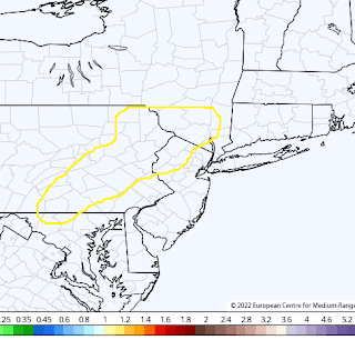
My map below is my first estimate of what impacts might be. I base this on how I think things will trend and does not reflect any particular model run...


As you can see I favor the storm to really hit eastern New England hard and graze by other parts. This of course can change if my ideas end up being wrong!

So lets go back to the models. As I showed yesterday, the east vs west track depends on how the northern and southern energy combine. If we see the southern energy hang back it means a late developing storm.

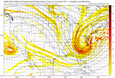
Looking at the GFS, you can see recent trends have been to hang back the energy more. Now I think this is actually overdone but it shows my point below...


You can see the energy over TX trending slower. At the surface this mean storm forms more east...


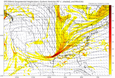
Now the GFS may be overdoing the east track here. On the other extreme, the European had an epic blizzard yesterday but overnight has trended more east...


It still shows a blockbuster storm however below....


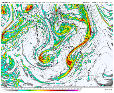
This is worst case scenario as of now. I like the Canadian model below which splits the difference between the more east GFS and more west European...


So that's where we are at currently. We are less than 3 days away so forecasts have to be made. 
Regardless of where this tracks, this storm will become extremely powerful with off the charts atmospheric dynamics.

 By tomorrow morning we will have more more clarity on this and I will update my map if necessary. Stay tuned. 

Tuesday, January 25, 2022

Tuesday: Most Models Trend East, Euro West

Good morning. We will continue to focus on the weekend storm threat today. At this time most major modeling  has trended east which means the storm hits eastern New England. The one model that still has a very powerful storm impacting the whole Northeast is the European. After looking at everything carefully, I lean towards the non European eastern solution. This by no means is stone, but I will explain below.


Taking a look at projections, here is the spread for storm Saturday...

GFS...


Canadian..


And finally the European with an epic blizzard...


So clearly as of now the European is an outlier. What makes me have reservations about what it is showing are a few things.

For one, the European model tends to over amplify things as its bias. For two, its ensemble package is east of its main operational model with its projection of the low center seen below...


So why the difference? Its all due to how the energy in the jet stream is being handled. The models are are east are not allowing the southern energy in the jet stream to consolidate and phase with the northern energy. Below you will see how the southern energy is "dragging its heals" causing a less consolidated storm. Part of this is also due to the ridge out west not being as strong, allowing this energy to hang back...


This doesn't allow an early phase of the jet streams and the result is a storm that forms more east. There has been a tendency this year to not allow energy to eject out of Texas easily and we are seeing it projected again here. 

So the bottom line is as of now I agree with most modeling that the more east solution could make sense. However, given it is Tuesday this can all change and I can be wrong. 

Will the European score a major win here?

Time will tell stay tuned. 


Monday, January 24, 2022

Monday Weather Update: Need to Watch This Weekend

 Good morning. Over last several days there has been speculation that a big storm could develop this weekend along the east coast. There is some merit to this. Although the pattern isn't exactly what I want to see, there is a lot of cold air and strong energy that will be entering the country in both the northern and southern jet streams. If this all comes together as some models indicate, then we get a big storm. The one issue with this threat however is the lack of blocking in the atmosphere. This means the storm will be all timing based as we do not have a big feature in place to slow everything down.

Lets take a quick look...


What you see above is projected energy in the jet stream from the GFS model for Friday. I highlighted the features or ingredients for this storm threat. It will all come down to the positioning and timing of the very strong northern and southern jet stream energy as you see above. If these two pieces of energy are not strung out and catch up to each other, a powerful low pressure system forms and moves up the coast.

Last nights model runs from multiple models showed this...


As you can see a major storm. However, based on those factors I explained above, this is far from set in stone. Because we do not have blocking or high pressure over Greenland, any changes in speed of those two pieces of energy can cause the storm to not for or be weak and out to sea. 


Looking at a range of solutions from the model ensemble system, you can see what I mean by the potential low locations scattered...


So bottom line is we have something to track here. I assign a 40/60 probability at this time of something to impact the east coast. 

Stay tuned for updates. As I get more data next two days I will start to take a stab at making a prediction as always. 

Thursday, January 20, 2022

Thursday Morning: Light Snow, No Storm This Weekend

 Good morning. Rain is changing to light to moderate snow across the area this morning. Accumulations will end up staying on the tame end. Expect a dusting to local 1" in spots. This is just a nuisance at best. Nothing to be worried about. Roads overall should be ok.

The weekend storm is out to sea. The next chance for snowfall will be middle of next week. More on that as things evolve.

Enjoy the day. 

Wednesday, January 19, 2022

Wednesday: Accumulating Snow Tomorrow Morning, Weekend Storm Needs Trends

 Good morning. A frontal passage moves through the area tonight with accumulating snow tomorrow morning on its backside. Expect a few inches of snow for most to accumulate during tomorrows morning rush hour. General accumulation amounts of 1-3" can be expected.

We then still have to watch the weekend for storm development. Chances of this storm occurring have DECREASED last 24 hours but we are not out of the woods yet. I will explain below.

Starting with tomorrow mornings frontal passage, snow is projected to move in before daybreak...


Above is radar projected at 7am. Initial rain for some to south changes to snow by daybreak. The snow will linger till early afternoon. Given its timing, it will have rush hour impacts.

Not enough to warrant my own accumulation map but I like this models projection of amounts below...


As you can see a healthy band of 1-3". 3 inch amounts I would favor in the higher elevations to the northwest.

Moving on, cold air takes hold as we head into the weekend. As of now most model guidance keeps the weekend storm threat out to sea. I would not count this 100% out yet. We have see all winter storms trend west at the last second. If that happens this time, then we will be talking a snowstorm for the Mid-Atlantic up to Southern New England. 

The only model still insisting this can come more inland is the European...


An outlier solution. Taking a look at model ensembles, the other models despite out to sea, do have some ensemble members flirting with a track closer to the coast.

It will all comes down to how the models handle the northern and southern piece of short wave energy. If the energy is more strung out there is not much to talk about. If it starts trending more amplified next 24 hours then we need to watch for impacts in the Mid-Atlantic.


For storm development we need to see the energy in the circle to the north go sharper and the energy in the circle to the south to eject out faster and not be as strung out. 

I will evaluate trends today and if I think this has merit I will start to jump on it tomorrow. For now, we just need to be patient. 

More later. 


Tuesday, January 18, 2022

Tuesday Weather Outlook: Tracking Next Storm Threat

 Good morning. I did a twitter video last night you can find on the right hand pane of this webpage. In the video I discuss the chances of another winter storm on Saturday. The bottom line is, at this time it is still very up in the air. Most models do not have a storm threat with the exception of the European model. In these situations either the European model is on to something or it is out to lunch. By tonight, we should have enough clarity to start to make predictions.

In the meantime, we will have a frontal passage on Thursday morning which could drop a little bit of light snow across the area...


The jury is still out if this amplifies enough north to cause a few inches of snow but at this time I assign a 50% chance. We will discuss this more tomorrow morning. 

Back to the weekend threat, the European model has been very amplified with the storm energy in the jet stream and has a storm closer to the coast...


GFS and all other major model guidance says storm stays off the coast...


The European is either out to lunch or is on to something here. Usually I would say in this situation it is out to lunch. The only area of pause I have is that storm as of late have been trending west with time. This makes be think there is a shot for something on Saturday.

Stay tuned, more to come. 

Monday, January 17, 2022

Morning Update: Storm Winding Down Over Tri State, Show Showers Later

 Good morning. Our storm is currently winding down over the tri state with heavy snow still in the mountains of New England. I recorded 3.5" last night in NW NJ and still have 2.5 on the ground despite the rain last night. Temperatures never broke 35 degrees here. Low level cold was under modeled. 

Here is our current radar. Snowing heavy in ski areas and western NY...


Back end snow showers will move into NW NJ NE PA over next several hours as cold air filters back in behind the upper level low.

We will tally up the finals later today but overall the forecast appears to have worked out well.

Cold air moves in this afternoon and temps go below freezing again. Cold air them stays in place all week. Signs point to a very cold 2nd half of January.

We then have to start tracking our next storm threat for this weekend. I will take the time to go through it today and determine if I think it is a legitimate threat. 

Stay tuned!

Sunday, January 16, 2022

Afternoon Video Update


See this mornings full forecast below...more coverage to come.

Sunday Morning Update: Final Forecast

 Good morning. Below is my final forecast for late this afternoon into Monday. I made some final adjustments and honed in on where I think an initial burst of accumulating snow can occur...


As you can see I extended the 4-8" into NW NJ  and parts of CT. This is based on recent data to support the idea I had that the low level cold can hold on a little longer tonight as the initial burst of snow comes in.

Here is a Summary:

  • Snow moves into areas late this afternoon/evening south to north.
  • The initial burst of snow could be quite heavy in the pink and blue zones later this evening. 
  • Snow then changes to sleet, freezing rain then plain rain by after midnight Monday for pink and blue zone.
    • My feeling is a decent amount of frozen precipitation can fall before this
  • For the Green zones a little initial snow to rain is expected. 
    • Light green zone can see around an inch of snow
  • For the far interior/ski areas over a foot can be expected
  • The winds really start picking up late tonight into Monday morning
  • Main storm is over by around daybreak Monday
    • Back end snow showers can be expected late Monday morning/afternoon for most areas

    It is cold outside! Temperatures are in the single digits and models are finally starting to realize this cold air will not be easy to move. The result is frozen precipitation being projected to hold on a little longer in areas to the NW in pink and blue zones. Due to the fact we now have data to support my suspicion, I increased the totals there for the final update.

    Looking at the projected radar for this storm you can see the initial burst of snow then changeover to ice and rain at the end...


    This will be fun to watch on the radar later tonight. I will be reporting from my house in NW NJ and I am hoping I can see at least 4" before this changes over.

    Also notice the back end snow showers late Monday morning being projected. To the fact we will have a rapidly deepening upper low, I think this will verify.

    Stay tuned. I will have a 5pm update tonight just as the storm is on approach.

    P.S. The weather pattern will stay very cold and active through rest of January. Next storm threat I am tracking is for Saturday. More after we get through this one.

    Saturday, January 15, 2022

    Saturday Morning Forecast Update


    I want to add this map to my morning post. This area I am most concerned about for heavier initial snow to ice conditions. Any rain I am thinking will be at the end and not last long. Temperatures will go above freezing for a few hours then crash back below freezing by Monday afternoon with snow showers.


    See morning post below with updated forecast...video later today to break it all down...

    <<<<<<<<<<<<

    Good morning. Very very cold air is currently over the area with temperatures for many in the single digits. This is the cold air that will be ahead of our storm that moves in tomorrow night. Believe it or not the storm will try to erode this air fairly quickly and many areas will see rain or a mix of snow and ice. Recent model guidance has really insisted the warm air wins out with this storm due to a very powerful stream of high winds developing in the lower atmosphere. I still think the models are overdoing the magnitude of the warm air but regardless I have incorporated it into my updated map. 

    My final forecast is out tomorrow morning. 

    Here is a summary:

    • Storm moves in late tomorrow afternoon/evening for most
    • Expect an initial burst of accumulating snow for areas off the coasts NW of I-95 for a few hours Sunday night.
      • Indications are this moves in pretty fast
      • For areas near coasts and SE of I-95 this is mostly a rain storm

      • The snow will then change to sleet and rain for many
      • Winds will be gusting over 35 mph and as high as 50mph near coastal areas Saturday morning
      • Storm tapers off Monday afternoon with backend snow showers for most

      Here is my updated map:


      As you can see I made some west shifts from yesterday. This was necessary based on recent observations. That pink zone is the most interesting to forecast for this storm. It will be a wildcard for how much snow falls. 2-4" including sleet is a very good middle ground at this time.

      Recent models show the initial snow Sunday evening with warm air and rain trying to race in on the eastern flank...


      I like what the European model is doing above. The cold air that is over our area now is fresh and dense. It will take some time to erode it initially on Sunday so I do see a nice burst of snow to the NW as this model shows. 

      Eventually however due to a very powerful jet stream of warm winds at 5000ft things will turn to ice and rain. Below shows that jet stream of winds...


      The brown streak is warm air and high wind rushing in from the south. If we had our upper level low pressure system more east this wouldn't be as much of a concern. That low pressure center however moves just to our west seen by the blue circle...


      Heavy snowfall happens just to the north west of upper level (18000ft) low pressure centers. 

      Over the next 24 hours I want to see how models handle this upper level low with the fresh cold air ahead of it. I Still believe there is a chance it can not cut as far inland and what many think right now due to under estimating the strength of the cold. In English that means more frozen precipitation can be supported in the pink zone.

      Stay tuned. Will have an update tonight.