Good morning. I have never seen such hype over a big storm on social media as I saw yesterday. As I shared in the morning, the European model was very aggressive with blowing up a winter storm and crushing the whole east coast this weekend. Meanwhile, some other data indicated otherwise. Well, this all spiraled out of control yesterday afternoon when the European model continued to show a massive storm. The media jumped on it and the rest is history. Then late last night new data came in and the European shifted a little east.
We are still three days away so nothing is set in stone. However, as I shared with you yesterday the European model has been known to over amplify storms and has a bias to track too far west. When I see other modeling/data that suggests otherwise I look at it closely to see if in makes sense. In this case, I favored and continue to favor the more eastern track of this storm.
So what's the bottom line?
- A big east coast storm will likely form off the east coast Friday night into Saturday
- Many regions should see flakes fly from this system, but at this time I favor eastern New England for largest impacts.
- To areas outside of Eastern New England, you need to be on alert but at this time I see more of the chance of moderate impacts.
- I want to emphasize the atmosphere is primed to produce an extremely powerful storm, so we need to monitor this closely for last min shifts.
My map below is my first estimate of what impacts might be. I base this on how I think things will trend and does not reflect any particular model run...
As you can see I favor the storm to really hit eastern New England hard and graze by other parts. This of course can change if my ideas end up being wrong!
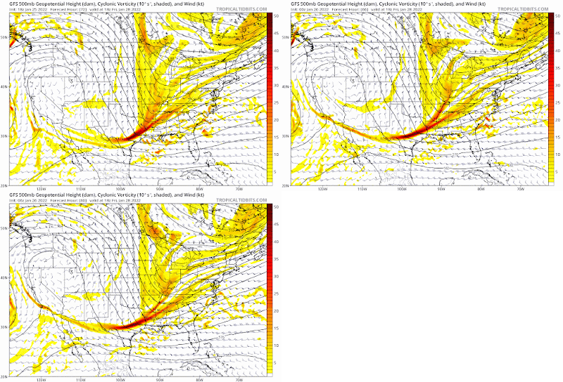
So lets go back to the models. As I showed yesterday, the east vs west track depends on how the northern and southern energy combine. If we see the southern energy hang back it means a late developing storm.
Looking at the GFS, you can see recent trends have been to hang back the energy more. Now I think this is actually overdone but it shows my point below...
You can see the energy over TX trending slower. At the surface this mean storm forms more east...
Now the GFS may be overdoing the east track here. On the other extreme, the European had an epic blizzard yesterday but overnight has trended more east...
It still shows a blockbuster storm however below....
This is worst case scenario as of now. I like the Canadian model below which splits the difference between the more east GFS and more west European...
So that's where we are at currently. We are less than 3 days away so forecasts have to be made.
Regardless of where this tracks, this storm will become extremely powerful with off the charts atmospheric dynamics.
By tomorrow morning we will have more more clarity on this and I will update my map if necessary. Stay tuned.


When is the snow supposed to start on Friday? Thanks Will!
ReplyDeletefriday night, but im not sold on major impacts for our area yet
Delete