WINTER OUTLOOK 2023 IS NOW LIVE

The 2023 Winter Outlook

Friday, October 30, 2020

630am Update: Things About to Get Interesting

 Good morning. Part two of our storm is now underway and its very impressive. You can see snow already breaking out as far south as Extreme NW NJ...


By the time we get to around 8am the snow line should make its way a little further south over all the highlands of NJ and into Southern New England...


This will start a 3 to 4 hour period where things will get very interesting. I expect snow to be flying in all areas above 800ft in NW NJ with chance at a dusting at 1000ft plus. The models have gotten a little more robust overnight.

By around 12pm this starts to taper down...


Updated model snowfall projections are still overdone but do look impressive...


I would say cut all this in half at least and you have a good idea of what should happen. Any amounts over an inch should be confined to the interior mountain areas only. 

Very cold air follows for tonight into tomorrow with lows in the upper 20's to low 30s tonight.

Stay tuned for observations from my backyard in NW NJ.

Thursday, October 29, 2020

Thursday: A Taste of Winter Weather for The Northeast Incoming

Good morning. A very robust storm system is currently approaching the area. This storm will feature heavy rain through today. The rain will be changing to snow up in interior New England and by tomorrow morning the flakes will be flying to areas as far south as NW NJ. However, I only expect accumulations in the mountain areas. Very cold air then takes hold through early next week.

Summary:

  • A soaking rain today as tropical moisture moves into the area
  • Rain starts to change to snow across the mountains of interior New England tonight
  • By daybreak tomorrow enough cold air moves in to change rain to snow across areas as far south as NE PA and NW NJ at higher elevations
    • Do not expect any accumulations but flakes should be flying in the air in areas above 800ft
    • Winds picks up as pressure gradient increases
  • Very cold air takes hold through early next week


Lets take a look.

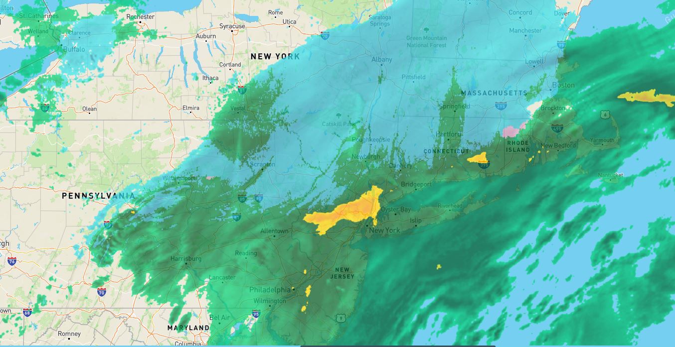
Moisture rich storm system is currently approaching the area aided by tropical moisture...


The front end of this is a soaking rain today...


As the storm passes east cold air starts to rush in due to the northern jet stream getting involved tonight...


This is where by after dark I expect areas like the ski resorts of New England to start reporting snow. Even the Catskills should get in on the action..


You can see the impressive jet stream dynamics below, I highlighted the northern jet diving in and supplying the cold air...


Now here is where things get interesting. A piece of energy lags behind the initial storm system. This piece moves into the region by late tonight into tomorrow morning which gives the cold air time to establish itself aloft. This means some snow should fly further south even in areas like the poconos and NW NJ at 1000ft +...


You can see below how this model shows the snow in those areas mentioned around daybreak tomorrow. Now I really do not expect accumulating snow in NJ or most of CT RI. The exception will be those elevations at 1000ft+ that can end up seeing a coating from this in those areas.

For snowfall amounts I really like what the European ensemble is printing out...


Notice the mountains of NY, VT,MA,NH show decent accumulating snow where areas outside those areas its basically up to a dusting. I tired to illustrate this above. I honestly would not expect anything to accumulate on the ground anywhere near the coast.

On the other hand, I do expect the Catskills, Greens, and White Mtns can see a decent snowfall from this. It will likely be more than what you see above. 5+ inches in some of those areas would not surprise me. 

In the wake of this storm temps will be very cold on Saturday. Lows in the 20's to 30s for many with highs in the 40s. Temps moderate slightly on Sunday just to get very cold again Monday and Tuesday. We can see more freezing at night with lows in the 20s and highs in the 30s and 40s for many. In NW NJ I think temps don't break 40 on Monday and Tuesday for some. 

Things then warm up. Stay tuned will have more updates. 


Monday, October 26, 2020

Winter Outlook 2021

*VIDEO IS NOW LIVE BELOW*

Welcome to the Winter of 2021 outlook! It is always fun to try to nail down what may happen for an upcoming winter season. I will say outside of generalizations, it can be nearly impossible to nail down specifics to what a winter may bring to each region IMO. Regardless, I tried to hone in on what will be in store for each region of the country. Considering most of my followers are on the east coast I will provide the most detail for this region.  If you enjoy the outlook, please feel free to share with family and friends. 

There will be two sections of this outlook:

Section One is the summary of what I expect for this upcoming winter. It will include my forecast maps for temperatures and snowfall along with a synopsis. 

Section Two will include a video that goes into some more in depth commentary on this winter and how I made the forecast for those that are interested. This will be released tomorrow morning (the 27th).


Section One: Summary of Winter 2020-2021

The Winter of 2021 should start relatively fast for the eastern 1/3 of the country. I expect winter to arrive on schedule in late November/ early December and feature temperatures that are normal to below normal from the Ohio Valley into the Mid-Atlantic and Northeast. There should be a few impressive cold shots that move across the country from the northern Plains into New England. This pattern will back off a little at times but should last through January and deliver a majority of this seasons snowfall in the Mid-Atlantic and southern New England. In terms of storm tracks, a big theme of this winter will be many events that include mixing as storms will try to cut to the west at time hitting interior New England with the heaviest snow. 

As we get into late January and February, I expect temperatures to moderate in the east with warmer than normal air taking over at times. This means a warmer storm track that hits many with mixed precipitation and rain. The exception should be Northern New England which should stay on the colder side of the storm tracks most of the time. 

All in all, I think we will look back on this winter and say it "was pretty typical" meaning most areas of the east see enough snow to say things where at least average despite some moderation and warm weather at times. I think at least one big storm is in the cards that will deliver impressive snows region wide. March will be a wildcard  (as it usually is) where if a winter pattern takes hold it can really tip the scales from an average to above average winter snowfall. We had this happen in 2018 which had a similar atmospheric setup.


Here are my forecast maps for Temperatures and Snowfall/Highlights:


As a reference to what is "normal", below is a map of normal seasonal snowfall for the region along with NJ.  Credit to www.lightinthestorm.com. You can click to make bigger...


Section Two:  Video Breakdown and Forecast Methodology 


Monday, October 19, 2020

WINTER OUTLOOK IS OUT MONDAY OCTOBER 26TH

 Stay tuned! In the meantime we will have a very pleasant week ahead. Temps mostly in 60's and 70s.

Wednesday, October 14, 2020

Wed the 14th: First Snows of the Season for Northern New England?

 Good morning. We are now in the heart of fall and winter is knocking on our doorstep. The type of winter we will have is still TBD imo as I am still working on my winter forecast . In the meantime however we have quite the pattern emerging. An awful lot of cold air will be pouring into the country from Canada next 7 days and there will be the chance for some snow in the mountains of New England later this weekend.


Lets take a look...

Below you are seeing what would be a nearly perfect winter pattern to allow cold air and storminess to mingle in the eastern 1/3 of the country. High pressure over the higher latitudes allows the cold air and energy to pool as seen by the dark blue...


As this cold air presses, a cold front moves into the area this weekend...


An area of low pressure is then expected to develop along this front and move northeast...


The model above, the European, shows snow breaking out in the mtns of northern New England as the storm plays with the cold air in the area. It is not alone as some other models show the same thing...


So what are my thoughts? The cold air is in place, there is enough atmospheric blocking to support a storm staying near the coast, so I think this is a very possible scenario. I would say several inches of snow in the mountains is possible late Saturday.

Stay tuned.