Thursday, January 31, 2019
Weather Willy In The News
Looks like the footage of the snow squall I captured yesterday made the news. The video below was featured on CNN. You will see my clip in the first 30 seconds. It really was some squall!
Wednesday, January 30, 2019
Wednesday: Arctic Blast Arrives Today With Snow Squalls
We have true arctic air on our doorstep this morning and we will feel it in a big way as it starts to enter our region this afternoon.
The core of the cold currently near Chicago is record breaking...

Although it will moderate some, the air still packs a punch when it hits our region this afternoon.
Temps start to crash after 12pm and reach close to subzero by early tomorrow morning..

We also may see a line of snow squalls develop this afternoon as the cold arctic air arrives...
 A snow squall is a brief intense burst of snow similar to a small thunderstorm. They usually occur when a very cold air mass moves abruptly into a region.
Things then stay cold for Thursday with highs in the low teens.
Temps then moderate by Saturday and Sunday.
The core of the cold currently near Chicago is record breaking...

Although it will moderate some, the air still packs a punch when it hits our region this afternoon.
Temps start to crash after 12pm and reach close to subzero by early tomorrow morning..

We also may see a line of snow squalls develop this afternoon as the cold arctic air arrives...

Things then stay cold for Thursday with highs in the low teens.
Temps then moderate by Saturday and Sunday.
Tuesday, January 29, 2019
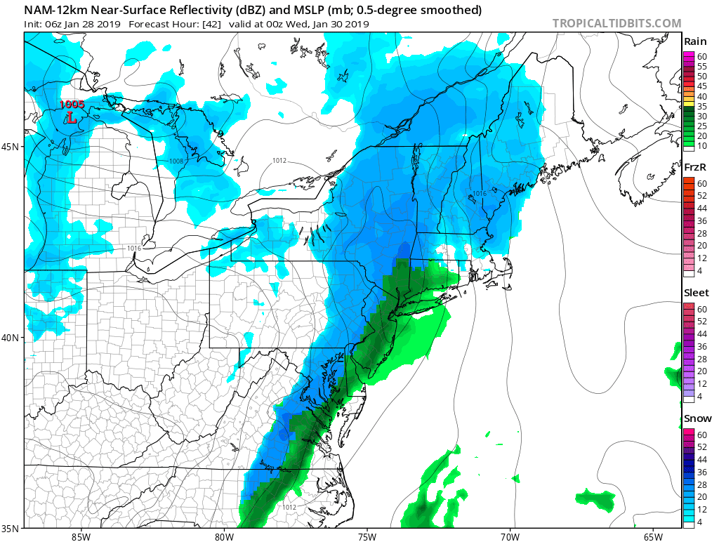
Tuesday Storm Update: Snow and Rain Hit Region Later, All Snow Tonight
7pm update:
No need to say much. This is playing out exactly as i expected for once. Several inches of snow to the NW with a changeover to snow working its way east. Limited accumulations there however.
Bitter cold on tap for rest of week.
<<<<<<<
Good morning. Sorry for no video last night, I got home later than expected. A light to moderate winter event will effect parts of the region today. Low pressure will develop along a cold front and bring precipitation into the area this afternoon into tonight. Expect rain or a mixed bag of precipitation to start for most areas with a few hours of snow at the tail end tonight.
Summary:
- Some light snow this morning but limited impacts
- Main impacts are tonight for most areas after 5pm
- Heavier snow and rain moves into the region this afternoon after 2 pm
- Expect snow in NW NJ at high elevations and a mix of rain and snow for other areas to start
- By 6-9 pm any rain should change to some snow for most areas
- 1-3 inches will accumulate in areas that saw rain/mix to start
- 3-6 inches for areas at high elevations in NW NJ and PA
- Storm is over between 8-11pm
- Bitter cold follows for Wednesday and Thursday as an arctic blast hits the region
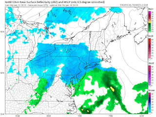
Here is an updated model snowfall map. Except for NW areas of the state, most of these 1-3 inch amounts occur tonight not today...

To the north, more snow falls in the interior..

In terms of storm timing, here is what to expect...
This morning light snow is seen on the radar, but nothing that will cause any impacts..

By the time we get to later this afternoon, snow breaks out to the northwest with rain or mixed precipitation for most areas..

The transition to all snow then occurs between 7-9pm..

This is where most areas pick up 1-3 inches. The storm is then over before midnight.
Bitter cold then starts to arrive Wednesday and peaks on Thursday. Temperatures on Thursday will struggle to get past the single digits...

This is all thanks to a piece of the polar vortex swinging through the area.
If you think this is bad, our friends out in the midwest will see recording breaking cold. Temperatures will go below -20 for many areas tomorrow with below-30 to the way north. This is EXTREME cold...

Luckily this moderates a little before it hits us.
In the long range things then moderate as we head towards next week. As I mentioned the other day, at this point snow lovers need to be happy with one big storm before the season is over. I think thats the best we can do at this point.
I will have an update tonight.
Monday, January 28, 2019
Monday: Snow for Some Tomorrow, Bitter Cold to Follow
Good morning. I am finishing up a ski trip in Stowe Vermont so limited post today. However, there is some snow in the forecast for tomorrow. There will be an 8pm video tnt when im home with more details.
Here is a summary:


Here is a summary:
- Accumulating snowfall hits the region tomorrow
- NW NJ into PA at high elevations get the most
- other areas can see an inch or two...this means most of you
- Snow arrives by late tomorrow morning or early afternoon and ends at night
- snow may start as rain for eastern areas
- General 3-5 inches for western areas and 1-2 for eastern areas of NJ
- very low or little snow near the coasts*
A low pressure center will be forming on an approaching front...
Snow may start to break out by early morning...

Rain can mix in for areas in eastern NJ with snow holding on in western areas by Tuesday afternoon...
By Tuesday evening even eastern areas of state should see SOME snow...

When it is all said and done, I think the European model has best snowfall forecast..

3-5 in NW areas of state. I would even say locally more than that at high elevations (5-8"). Notice how there is much less in eastern NJ.
Bitter cold follows for middle to end of the week.
If I have time I will cut video around 8pm tnt when I get home.
Friday, January 25, 2019
Friday: Arctic Press Comes Next Week
Impressive cold outbreak is on tap for next week from the Great Lakes to the east coast. The core of cold is over the lakes where areas like Chicago can see temps drop below -20! For our area not that cold but cold enough by the end of next week (single digits likely).
I will be watching for storm development on the front end (Wednesday-ish) and back end of this outbreak (Superbowl weekend-ish).
Can we finally break this snow drought? More to come this weekend. Stay tuned.

I will be watching for storm development on the front end (Wednesday-ish) and back end of this outbreak (Superbowl weekend-ish).
Can we finally break this snow drought? More to come this weekend. Stay tuned.

Thursday, January 24, 2019
Thursday: Loosing Patience With Winter, Cold Air Not The Issue
Good morning. There comes a point when you have to look at what is actually happening in the weather vs what the models are suggesting. So far this winter, it has not wanted to snow near the big cities of the east. Rain has not been an issue and it seems that any signifigant storm system we get dumps inches of rain on us. Today is a perfect example of this.
To make matters worse, in between these rain episodes we have had cold shots! So we have settled into the good old pattern of rain,cold,rain. It is January 24th and the clock is ticking on winter. At this point we need an historical run in February and early March (can't count on things like this) or the winter will be a bust in terms of snowfall. I think for the snow lover the best you can count on right now is one big storm before the end of the season. I would take that card in a second.
I am still watching next week for storm development as an impressive cold outbreak hits the country. The issue is I do not think there will be enough blocking, or in better terms a mechanism in place to keep that cold air locked in ahead of a storm. Regardless, we still need to keep our eye on the Monday to Wednesday time frame.
Looking at next week, storm or no storm, the polar vortex looks to visit..
 This is extremely impressive and is the coldest air in the northern hemisphere on our side of the globe...
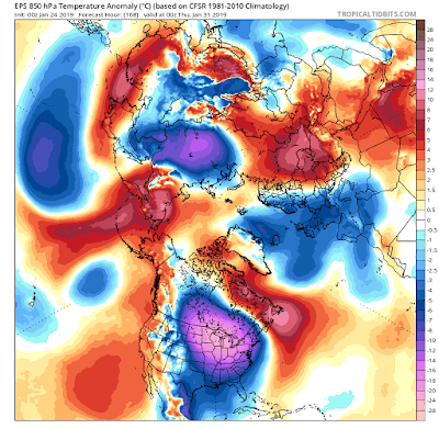 Temperatures will plummet to well below zero for the lakes region and the cold air will work its way to the east coast by the end of next week.
Again folks, the cold shots have not been the issue this year! That part of my winter forecast I may get right ironically. The issue is will this cold stay locked ahead of a storm. Right now there is no signal for that.
In many cases you look for storms on the front and back end of big cold outbreaks like this. The front end is next week where there is a shot something develops, then the back end is the following week. We will see if anything pops up.
Regardless, I think I made my point today. Expect nothing snow lovers and hope your surprised.
To make matters worse, in between these rain episodes we have had cold shots! So we have settled into the good old pattern of rain,cold,rain. It is January 24th and the clock is ticking on winter. At this point we need an historical run in February and early March (can't count on things like this) or the winter will be a bust in terms of snowfall. I think for the snow lover the best you can count on right now is one big storm before the end of the season. I would take that card in a second.
I am still watching next week for storm development as an impressive cold outbreak hits the country. The issue is I do not think there will be enough blocking, or in better terms a mechanism in place to keep that cold air locked in ahead of a storm. Regardless, we still need to keep our eye on the Monday to Wednesday time frame.
Looking at next week, storm or no storm, the polar vortex looks to visit..


Again folks, the cold shots have not been the issue this year! That part of my winter forecast I may get right ironically. The issue is will this cold stay locked ahead of a storm. Right now there is no signal for that.
In many cases you look for storms on the front and back end of big cold outbreaks like this. The front end is next week where there is a shot something develops, then the back end is the following week. We will see if anything pops up.
Regardless, I think I made my point today. Expect nothing snow lovers and hope your surprised.
Tuesday, January 22, 2019
Tuesday Update: Cold Relaxes This Week, Colder Weekend, Rumors of More Storms
Good morning. The impressive arctic blast currently over our area moves out today and temperatures climb back towards the 30s and 40s by tomorrow.


Rain then moves into the area on Thursday with a frontal system...

Rain is over by Thursday evening and there may be a few flakes on the backside of this front.
Some colder air then moves in for Friday into the weekend. This air will be slightly below normal with highs in the upper 20s and low 30s.
In terms of storm outlooks, there is the chance of storm development early next week...

Below is the potential setup for this...

Looking above, we have a few factors to track.
- Big ridge of high pressure developing over the Gulf of Alaska
- this drives cold air into the country from Canada
- Energy in the Gulf of Mexico with a negative tilted trough
- this enhances the chance for low pressure to develop
- I have not seen to many negative troughs this year yet
- A little big of blocking in the northwest Atlantic
- this if placed properly would aid in the storm not escaping out to sea
There are a few impressive components here, I will not lie. I love seeing energy that far south in the Gulf of Mexico and some blocking out ahead of it. However, based on how this winter has gone I am not inclined to jump the gun on this. Lets just see how things track over the next few days.
More to come.
Monday, January 21, 2019
Update Tomorrow
No post today. Tomorrow AM I will take a look at the next 7 to 10 days. This bitter arctic air (very impressive) leaves by Wednesday (slow exit) and we are faced with some rain mid week. Towards the end of this weekend we need to watch for some storm development but more on that tomorrow.
Saturday, January 19, 2019
730 am Update: Final Forecast, Made Some Changes
12pm Video Supplement: Warm Air Winning
**Don't forget brutal arctic air rushes in Sunday night. Monday morning will be in the single digits**<<<<<<<<<<<<<<<<<<<<<<<<<<<<<<<<<<<<<<<<<<<<
Good morning. A few changes to discuss this morning. The current data is coming in warmer than originally projected and that will have forecast implications today. It is time to get ahead of this and update things.
Summary:
- Storm is trending warmer than thought based on current observations
- This means rain will be more of a factor vs some initial ice and snow for many in the tri-state
- Ice and snow line now will be pushed more northwest on my new map
- NW NJ to southern New England can see high ice impacts (freezing rain)
- I circled region in yellow on my new map.
- Lower snow accumulations for some compared to yesterday
- Storm starts roughly around 5-7pm today.
- snow to start for many, changing over to ice and rain (see new map)
- Still bitter cold on Monday
So lets get to this:
The Final Forecast:

Although it may seem cold out now, the models are now insisting a warmer surge moves in by this afternoon. Image below shows the model trend in surface temperatures (warmer)...

My whole concern about today was that the dense cold air would hang in tough as the storm approached. However, as recent modeling trends show above, more warm air looks to move in as storm gets underway. Notice how the air may warm above freezing even up to northern NJ. We will have to see if this actually happens.
Here is an updated model projection of the storm starting at 5 pm today ending tomorrow morning...

Heavy snowfall for the interior with that ice zone more northwest than originally thought.
Here is current model consensus for the ice zone...


A narrow but potentially high impact band of freezing rain. That spells trouble.
Stay safe out there, I will have another update this evening as storm is underway.
Friday, January 18, 2019
6:30 Update: Winter Storm Hits Tomorrow
No changes to this mornings forecast guys. I like what I have. Strong front end thump of snow later tomorrow afternoon followed by sleet and freezing rain for many in NNJ. To the south it does change to plain rain. Storm over by late Sunday morning with bitter cold air to follow (close to 0). More details in my latest video. Final update out in the morning.
Friday: Updated Winter Storm Forecast
Good morning. The new data is in, and it is time to make a few tweaks to my original forecast. A major winter storm will be impacting most of the region Saturday into Sunday.As the story goes every single time no forecast is easy. In this case, my biggest concern is trying to nail down a narrow 20 mile band of freezing rain that I think will occur with this storm and cause big impacts. Also, trying to nail down where the heavy snow accumulations cutoff is the next challenge. Combining model data with experience I have come up with this as my updated forecast map.
The timing is Saturday afternoon through Sunday Morning...

Looking at this map the critical areas are the light and dark pink. Somewhere in this area should see signifigant icing. At this time I think its in the form of freezing rain for the light pink area. Just to the NW in the dark pink I expect more sleet than freezing rain. Some models are warmer than what I have and would shift this whole map NW but I think those models are under doing the cold air as I have discussed all week.
So lets get to the play by play of how this may evolve...
Very cold air settles into the region by Saturday morning...


For areas in CNJ northward, I think the initial few hours later on Saturday is a pretty good front end thump of snow where even areas like CNJ can see a few inches pile up with several more to the NW.
By the time we approach midnight below, warm air starts to work in aloft and the snow changes to sleet and freezing rain for many s...

This is the critical forecast point as models are mixed on how far north the mixing and rain line goes. Some have it more north than what you see above. I am going on the colder side here based on experience which is why I am showing this model.
Regardless, if I am right, surface temps stay cold for many during this critical period...
 This is where my iceing concerns come into play for areas in the light pink zone as there is a chance a good amount of freezing rain can occur.
As an example, this high resolution model at 4 am Sunday shows that freezing rain band. It is prob a little too far south in this model projection but you get my point...
 The pink to the north is a sleet storm. Again the placement of these features is still pretty uncertain but my forecast map tries to make a prediction.
By daybreak Sunday morning the back end of the storm approaches and the narrow freezing rain band and sleet continue with heavy heavy snow to the NW.
 There is a chance that just after daybreak things can change back to snow for areas seeing ice seen below...

The storm is over for many by late morning and by mid afternoon in New England.
Then comes a major major cold shot Sunday night which will cause any liquid areas to flash freeze by Monday morning...
Although this may be a little overdone you can see how serious this cold air is. Sub zero temps possibly all the way down to the NJ boarder...

The timing is Saturday afternoon through Sunday Morning...

Looking at this map the critical areas are the light and dark pink. Somewhere in this area should see signifigant icing. At this time I think its in the form of freezing rain for the light pink area. Just to the NW in the dark pink I expect more sleet than freezing rain. Some models are warmer than what I have and would shift this whole map NW but I think those models are under doing the cold air as I have discussed all week.
So lets get to the play by play of how this may evolve...
Very cold air settles into the region by Saturday morning...

A low pressure system loaded with moisture then begins to approach this cold air from the southwest...

By the time we get to mid afternoon Saturday or just past mid afternoon (3-7pm) Saturday, snow will start to break out for many areas in our region...

For areas in CNJ northward, I think the initial few hours later on Saturday is a pretty good front end thump of snow where even areas like CNJ can see a few inches pile up with several more to the NW.
By the time we approach midnight below, warm air starts to work in aloft and the snow changes to sleet and freezing rain for many s...

This is the critical forecast point as models are mixed on how far north the mixing and rain line goes. Some have it more north than what you see above. I am going on the colder side here based on experience which is why I am showing this model.
Regardless, if I am right, surface temps stay cold for many during this critical period...

As an example, this high resolution model at 4 am Sunday shows that freezing rain band. It is prob a little too far south in this model projection but you get my point...

By daybreak Sunday morning the back end of the storm approaches and the narrow freezing rain band and sleet continue with heavy heavy snow to the NW.


The storm is over for many by late morning and by mid afternoon in New England.
Then comes a major major cold shot Sunday night which will cause any liquid areas to flash freeze by Monday morning...
Although this may be a little overdone you can see how serious this cold air is. Sub zero temps possibly all the way down to the NJ boarder...

Snow and ice removal will be key Sunday ahead of this brutal air mass.
Stay tuned for my next update at 6pm tonight. I will be making the final tweaks if necessary to this forecast.
Thursday, January 17, 2019
830 Video: Taking a Look at This Weekend's Storm
No major changes from this morning. I will be updating my forecast in the morning based on the new data tonight. Regardless, I think this storm has big impacts for areas in the dark pink zone to the NW. The video goes into further detail.
Thursday: Major Winter Storm This Weekend, Major Ice NW of I-95 Possible
Good morning. As our weekend storm threat continues to close in on us, we can now try to sort out additional details. My post yesterday really broke down the setup for this storm and why I thought the cold air at the surface would put of a fight. I suggest you check out that post if you missed it.
Today I want to focus on some more detail behind what the major impacts will be. As I continue to look at updated models, one word keeps coming to mind, ice. Also, who ever does see more rain, temperatures are going to plumet Monday morning and cause a flash freeze. A lot going on!
Before I get to that, do not forget we have light snow coming in late tonight till daybreak. Expect 1-3 inches for many CNJ northward with locally 4 inch amounts by tomorrow morning.
Back to our weekend storm...
What will start for many as a front end thump of several inches of snow later on Saturday afternoon into Saturday night, will then transition to sleet then freezing rain. This is going to happen as precipitation rates really pick up. That means we can end up seeing signifigant ice accumulations by Sunday. My updated map below illustrates my point...

First off for areas in dark blue, this is an all out snowstorm with well over a foot of snow for many. The region I want to focus on however is the dark pink where after several inches of snow fall, we can see over a half inch of ice accumulate. That would not be a good situation and we need to monitor closely. Remember just because you many only see 4 inches of snow, that does not mean impacts are low. The ice to follow will be a much bigger threat.
Lets take a look at model projections. I am using the NAM model because I think it looks correct...
What starts as a front end thump of snow Saturday afternoon...
 Changes over to ice as warm air works its way in aloft...
 Due to the deep arctic air mass ahead of this storm...
 Temperatures at the surface are not looking to budge seen blow, despite the fact warm air will work in aloft....


Today I want to focus on some more detail behind what the major impacts will be. As I continue to look at updated models, one word keeps coming to mind, ice. Also, who ever does see more rain, temperatures are going to plumet Monday morning and cause a flash freeze. A lot going on!
Before I get to that, do not forget we have light snow coming in late tonight till daybreak. Expect 1-3 inches for many CNJ northward with locally 4 inch amounts by tomorrow morning.
Back to our weekend storm...
What will start for many as a front end thump of several inches of snow later on Saturday afternoon into Saturday night, will then transition to sleet then freezing rain. This is going to happen as precipitation rates really pick up. That means we can end up seeing signifigant ice accumulations by Sunday. My updated map below illustrates my point...

First off for areas in dark blue, this is an all out snowstorm with well over a foot of snow for many. The region I want to focus on however is the dark pink where after several inches of snow fall, we can see over a half inch of ice accumulate. That would not be a good situation and we need to monitor closely. Remember just because you many only see 4 inches of snow, that does not mean impacts are low. The ice to follow will be a much bigger threat.
Lets take a look at model projections. I am using the NAM model because I think it looks correct...
What starts as a front end thump of snow Saturday afternoon...


This spells ice storm and I am concerned there will be big impacts.
To make matters worse, bitter cold air moves in on Monday morning with temps in single digits and teens causing a flash freeze...

We still are 2.5 days away from this event. Things can change to warmer/colder as always. However, I think its important folks know whats on the table here. If it trends warmer, the map will shift NW if it trends colder, snow amounts will increase and the map shifts SE. I do think what I have looks good however.
There will be a video tonight around 830 pm to break all of this down.
Wednesday, January 16, 2019
Wednesday: Significant Weekend Storm, Colder Solution Prevailing
Good morning. We have a lot to talk about today as I am getting some more clarity on what will be a major weekend winter storm for many Saturday into Sunday. After a few days of evaluating the weather pattern ahead of the storm and the updated model guidance, one thing is standing out to me, we can not fight the dense cold air that will be out ahead of this storm. Models are now catching on to this idea and are not eroding away that cold air as quickly as originally thought. Translation, there is a good chance we are in for a heavy interior snowfall, and a potential high impact snow/ice storm for areas I-95 NW Saturday into Sunday. I have updated my winter storm outlook index! Our pattern change is here folks.
Real quick, before we get there, we will have a light snowfall event on Friday morning for all areas in CNJ north...
 Expect a general 1-2 inches for many but higher amounts (2-4) in the higher elevations of NW NJ and into New England with this. More of a nuisance but it could cause some travel headaches Friday morning. Snowfall rates should not be too heavy however. It is over by 10am Friday.
Now, this minor storm sets the stage for the bigger storm for the weekend. Remember how in my Monday post I went into detail how the cold air this minor storm drapes down will set up a natural boundary between warm and cold air for the weekend storm to ride along.
Well, the cold air will be very cold, very dense, and very impressive by Saturday morning...
 Sub zero in northern New England with temps in low to mid 20s for I-95.

Here is where things have been changing over last 24 hours on the models and the more I look at it the more it makes sense to me. It is not easy to just wipe out cold air like this. What normally happens is the cold air is under modeled. This means that although the warm air may with aloft, the temps hold firmer at the surface. This means only one thing- snow to ice/freezing rain. That outcome now is looking more likely for folks along the I-95 NW.
The big trend to really show this has been at 18,000ft where the models now are suggesting the northern jet stream does not try to phase early with the southern jet stream. This phase would have aided in warmer air moving into the region. The fact that that may not happen as early now means the cold air has a better chance of putting up a fight. The animation below shows the trend away from the phase as seen by energy in Canada retreating...


When it is all said and done here are my initial thoughts on what impacts may be. Remember this can change considering it is only Wednesday..

Stay tuned, I will likely have a video tonight around 7pm. Lets see if the colder trend verifies.
Real quick, before we get there, we will have a light snowfall event on Friday morning for all areas in CNJ north...

Now, this minor storm sets the stage for the bigger storm for the weekend. Remember how in my Monday post I went into detail how the cold air this minor storm drapes down will set up a natural boundary between warm and cold air for the weekend storm to ride along.
Well, the cold air will be very cold, very dense, and very impressive by Saturday morning...

The approaching storm is going to have to run into this dense cold air and try to fight it off...

The big trend to really show this has been at 18,000ft where the models now are suggesting the northern jet stream does not try to phase early with the southern jet stream. This phase would have aided in warmer air moving into the region. The fact that that may not happen as early now means the cold air has a better chance of putting up a fight. The animation below shows the trend away from the phase as seen by energy in Canada retreating...

I noticed this start yesterday and the trend has continue overnight. Major forecast implication if this stays true.
So what does this mean for impacts?
A front end thump of heavy snow now look like it can happen for many on Saturday afternoon/evening..

This would mean a several inches could pile up quickly later on Saturday night for many areas seen in blue above.
Then the warm air aloft should start to influence this storm and a changeover to ice occurs by early Sunday morning...

This will be a mix of snow, sleet and freezing rain for areas in the pink and eventually could change to all freezing rain for some. With surface temps holding steady near freezing, we can see big ice issues with this for many.
There then are indications we see a changeover back to some snow at the end of the storm Sunday afternoon/night. This detail still remains unclear...


Stay tuned, I will likely have a video tonight around 7pm. Lets see if the colder trend verifies.
Tuesday, January 15, 2019
Tuesday: Interior Snow Threat for Weekend, Light Snow Friday
Good morning. In a time crunch this morning but I want to give an update on my post from yesterday. I laid out the factors for the weekends storm and mentioned why I thought it was more of an interior snow threat. Those thoughts have not changed and the models are also suggesting that is the outcome at this time. This means all areas to the SE of New England see snow changing to ice and rain Saturday night into Sunday.
Beforehand however, we will have a nice light snow event for areas Thursday night into Friday morning...
 This looks like a 1-3 incher for many and 2-4 incher for the higher elevations of NW NJ and PA into New England. Again timing is Thursday night into early Friday morning. I will have more details on this tomorrow.
Then the main storm Saturday night...
What starts as snow early...
 Changes over...
 For the interior we are going to likely see well over a foot of snow fall with this. Ski areas will be happy.
Things can still change but I think the projection above makes sense given the setup I described yesterday.
I will have more details coming by tomorrow. Need to head to the day job.
Beforehand however, we will have a nice light snow event for areas Thursday night into Friday morning...

Then the main storm Saturday night...
What starts as snow early...


Things can still change but I think the projection above makes sense given the setup I described yesterday.
I will have more details coming by tomorrow. Need to head to the day job.
Subscribe to:
Posts (Atom)