WINTER OUTLOOK 2023 IS NOW LIVE

The 2023 Winter Outlook

Wednesday, August 31, 2016

Wednesday Evening Tropical Update: Mid Atlantic Now In Impact Zone

Good evening everybody. The short video below gives my latest breakdown of Tropical Storm Hermine and the impact it will have in the south as well as for our area. Here is a summary:


  • Tropical storm Hermine has formed today in the Gulf. 
  • It will make landfall near the Florida Panhandle with tropical storm force winds (40-50 knots)
  • The storm will then work its way up the coast and should stall out near the Mid-Atlantic due to blocking high pressure
  • This means heavy rain for the Mid-Atlantic and high winds at the beach areas later Saturday and especially Sunday
    • Flooding and beach erosion is a concern of mine
  • I will be tracking this daily so keep checking in for updates
Enjoy the video...


STAY TUNED FOR IMPORTANT UPDATES ON TROPICAL STORM HERMINE AND WEEKEND IMPACTS

8PM

Monday, August 29, 2016

Monday Morning Weather Discussion: Dual Tropical Storm Threat This Week

Good morning, hope everyone had a good weekend. The focus today will be on tracking two tropical depressions that will effect the country this week. We have been discussing the main threat since last week and now it is time to hone in on impacts.

As an overview, here is the current state of the Atlantic..


You can see three main systems on this image. Tropical depression 9 is the main concern as 8 will scrape by the outer banks and hurricane Gaston will not hit land. 

As stands most major models take tropical depression into the Gulf of Mexico then curve it northeast into Flordia...


In terms of intensity, many of these hurricane models project this makes it to tropical storm strength..

I agree with this projection. I do not think however that this becomes a hurricane. Regardless, it will still have impacts on northwestern Flordia and possibly the coastal Carolinas by the time we get to the end of this week.

The National Hurricane Center is onboard with this..


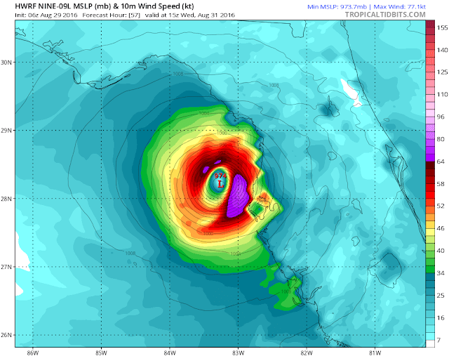
The most aggressive projections of this storm are from the two main operational hurricane models. The HWRF model for example has a Cat 1 storm at landfall...


The pink colors represent winds 65 knots plus. I think this is overdone and these hurricane models have been overdone before. I do like this track however and think the west coast of Florida sees at least 40 mph sustained winds with gusts up to 65. 

A lot can still change with this storm in terms of track and intensity. I think after the next two days we will get a much clearer picture. Regardless, the tropics are going to maintain extremely active for the foreseeable future. 

I will comment more this week. Thanks for reading. 

Thursday, August 25, 2016

Thursday Morning Tropical Update: Florida and Gulf States in Crosshairs

Good morning everyone. I wanted to do a quick tropical update on the developing tropical wave that is currently approaching the Caribbean...

The national hurricane center now gives this a 50% chance of developing into a tropical storm which would be named Hermine. 

Current model guidance brings this to a land falling tropical cyclone...


National Hurricane Center agrees...


The question is how strong does this get. I am fairly confident we see this become at least a Tropical Storm. If this is able to track into the Gulf of Mexico then I see the opportunity for additional strengthening into a hurricane.

Right now I like the European models projection the best..


This tries to develop towards a Cat 1 hurricane, but would likely stay a tropical storm. IF we see a track just to the west of this then it will have a better chance to develop over the warm Gulf. At this time I give that possibility equal chances.

More updates tomorrow. 

Monday, August 22, 2016

Monday Morning Weather Discussion: Tracking the Tropics

Good morning everyone. Well it is that time of year where we need to keep our eye on the tropics and the development and threat of hurricanes/tropical storms. Currently the Atlantic is in a very favorable state for storm development and we already have a few disturbances on the maps to track. Before we get there lets do a quick summary of this week's weather..


  • The week will start off cooler than normal with temperatures in the low to mid 80's.
    • This is the result of a front that moved through yesterday
  • As we head towards the end of the week temps will rise into the mid to high 80's but not many chances for unsettled weather in sight
  • For the most part, a picture perfect week.

Back to the tropics. The National Hurricane Center currently has there eye on a few systems..


The first storm named Fiona is projected to curve away from land and not become an imminent threat over next few days. You can see model projections on this below..


The second two systems however could be more of a concern. Initially, we are going to have to closely track the yellow X (called invest 99L) which is projected to potentially develop into a tropical system. Right now models are projecting this can be a land threat..


The next few days should give us a lot of information on how strong this system gets (does it become a tropical storm) and if it will track more north or south of this spread you are seeing. 

I am not going to focus on looking at individual model projections on this storm yet. Some of them, such as the Canadian weather model, have been insisting this hits the US but it would be premature to show those outputs at this time. 

Regardless, we need to be on alert especially given how warm the water in the tropics is currently. This gives the storm fuel to develop all else equal..


After we track and resolve the fate of this system, more threats should stay on the horizon as we are now entering the most active period of the tropical season.

More to come, stay tuned. 

Friday, August 19, 2016

A Nice Weekend Ahead/Tropics Heating Up

Not much to talk about for this weekend, nice weather on tap until later Sunday.

We are going to have to start keepin an eye on the tropics. Models and overall conditions indicate action is on the horizon. We will have to monitor over next 2 weeks if any developing storms are a land threat. I will start to comment in more depth on Sunday night or Monday morning.

Enjoy weekend.

Monday, August 15, 2016

Monday Morning Weekly Outlook: Some Slight Relief, But Overall Hot Conditions Prevail

Well there is no question it has been a miserable stretch of hot and humid weather over the last 5 days. The culprit of all of this is a high pressure system off the Atlantic coast spinning up all the hot and humid air into our area (Bermuda High)...


As this week progresses, we will start to at least get relief in the form of lower humidity. Temps will still mostly be in the 90's but a shift in wind direction to west-northwest will help keep the stickiness down. 


As we head into later in the day Tuesday, a low pressure system passing to our north will cause unsettled conditions with storms firing up...


We will have to keep an eye out for some of these storms being more severe with high winds and heavy rain Tuesday afternoon and night. 

In the wake of this Wednesday will be calm with low humidity and temperatures in the high 80s. 

On Thursday, a weak cold front should pass through the area. This means there is the chance at a few storms but the models at this time are not too impressed. 

As we get into the weekend, I see big relief finally in sight. That offshore high pressure finally starts to move away and we get calm conditions with temperatures in the low to mid 80s.


Monday, August 8, 2016

Monday Morning Weekly Weather Summary: From Comfortable to Hot & Humid

Good morning. We are about to have an excellent start to the work week. Temperatures today and tomorrow will move into the 80's but with very little humidity. This means conditions outside will feel perfect. This is due to high pressure system in the Great Lakes that is causing a northwest flow of air into the region. 

Things start to change Tuesday night into Wednesday as a warm front enters the area. From the Tuesday through Saturday time period, we will experience very hot and humid conditions with rounds of thunderstorms possible each day. 

As the warm front passes Tuesday night and Wednesday, expect storms to flare up by Wednesday afternoon..


This trend continues Thursday and Friday afternoon as daytime heating causes more storm to pop up each afternoon..


The weekend also looks to be hot, humid and unstable. It doesn't look like we get a relief from this heat until sometime early next week. 

Why so hot and humid? The jet stream is going to rise over our area. This allows warm moist air from the south to flow up into the region. You can see this below..


Thats all for now, thanks for reading. 

Wednesday, August 3, 2016

A Factor in Winter: The Pacific Decadal Oscillation

Good morning everyone. As I mentioned, I am going to start to highlight factors that can drive our winter pattern over the next month. Of course we cannot make any predictions yet, but it is a good time to at least take a look at how different variables impact the season.

One of those variables is the Pacific Decadal Oscillation. In simple terms, the PDO is a sea surface temperature pattern in the north pacific. It has two phases positive and negative. Both phases tend to effect the overall pattern in different ways.

Looking above you see two different phases of the PDO. On the left is the positive phase and on the right is the negative phase. Notice how in the positive phase we have a horseshoe of warmer than normal water off coast of North America extending down towards equator. Also notice the cold pool of water off shore. The opposite of this is on the right image.


The next image shows our current sea surface temperate anomalies.  It may not be as clear cut as my example image, but we are currently in a positive PDO.

In fact, if we take a look at model projections for winter you can see how there is evidence this continues..


So what does this mean?

In most cases you want a +PDO for a good winter season. This pattern supports a trough south of the Aleutian islands of Alaska which in turn supports a ridge in the west and trough in the east. The next image below shows all the winters that have had a +PDO and how the jet stream set up as an example...

Cooler colors are low pressure or dips in the jet stream and warmer colors are higher pressure or a rising jet stream. Pretty strong signal for colder and stormier than normal conditions along the east. Of course, this is not only factor that matters and is simply only a blend of many years some of which did not look like this. 

One of those other major factors will be once again the El Nino Southern Oscillation (ENSO). This past winter we had a killer strong El Nino which dominated our weather pattern. This year that has shifted and we are more towards an La Nina state. However, La Ninas are not as favored during +PDO's (there has been research done on this connection) which lines us up for a very weak La Nina or no La Nina at all.

I will comment more on this at another time along with other factors that will drive the winter forecast. 

Thanks for reading. 

Tuesday, August 2, 2016

Tuesday Morning Weather Discussion: Tropics Showing Signs of Life

Good morning everyone. Few quick topics to cover today. Want to give the usual rundown of the week and highlight a tropical system that is currently developing.

First to this week..


  • Very calm through Friday with mostly sunny skies and temperatures in the low to mid 80s.
  • On Saturday, we have a frontal system that will move through that could cause a few scattered showers and storms
  • Other than this small bump in the road one of the better weeks of the summer on tap

Moving on to the tropics...

We currently have a system down in the Caribbean that will likely turn to a tropical storm today...

A zoomed in view shows an organizing system..


Pretty much a non treat to the US. This will track due east..

We will have to monitor how strong this gets in next few days.

Thats all for now. Post coming tonight on the Pacific Decadal Oscillation and its influence on the winter season.