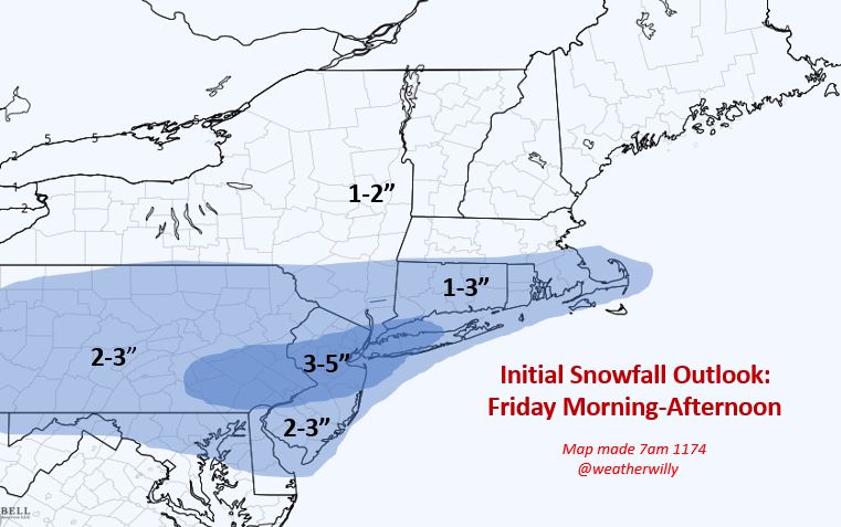
Good morning. Our moderate snow event is still on track for Friday. Timing is Friday morning through the evening. It looks like the heavier precipitation will arrive around 10-11am tomorrow morning. This setup still has a high degree of volatility meaning we can see last min shift up to the time of the event with the narrow heavier band of snow. I am keeping my forecast from yesterday and I do not have any overwhelming data to change it. I will have a final update at 9pm tonight. It is my best estimate of where this heavy snow can set up at this time.
Lets take a loo at the expected evolution. This storm involves an initial batch of energy that will move offshore early Friday, then a trailing arctic wave that will try to capture part of it causing an extended period of snow for the daytime Friday. These capture situation are very hard to nail down...
Light snow should be in the area around daybreak tomorrow...

By time we approach afternoon it is snowing decent in most areas...

Around 7pm things should start to taper down...

Models are still spread in their precipitation outputs but a good middle ground is what the NAM model has...

Given it will be very cold across northern zones during this event add an inch or two to the amounts to account for higher snow ratios.
Very cold air then settles in for the weekend.
Stay tuned final update tonight around 9pm.
Recording the success in Cryptocurrency, Bitcoin is not just buying and holding till when bitcoin sky-rocks, this has been longed abolished by intelligent traders ,mostly now that bitcoin bull is still controlling the market after successfully defended the $60,000 support level once again and this is likely to trigger a possible move towards $90,000 resistance area However , it's is best advice you find a working strategy by hub/daily signals that works well in other to accumulate and grow a very strong portfolio ahead. I have been trading with Mr Bernie Doran daily signals and strategy, on his platform, and his guidance makes trading less stressful and more profit despite the recent fluctuations. I was able to easily increase my portfolio in just 3weeks of trading with his daily signals, growing my $3500 to $65,000. Mr Bernie’s daily signals are very accurate and yields a great positive return on investment. I really enjoy trading with him and I'm still trading with him, He is available to give assistance to anyone who love crypto trading and beginners on the trade market , he can also help you recover/retrieve lost or stolen cryptocurrencies, you contact him on WhatsApp : + 1424(285)-0682 , Gmail : BERNIEDORANSIGNALS@GMAIL.COM for inquiries , Crypto is taking over the world
ReplyDeleteGood morning. Our moderate snow event is still on track for Friday. Timing is Friday morning through the evening. It looks like the heavier precipitation will arrive around 10-11am tomorrow morning. This setup still has a high degree of volatility meaning we can see last min shift up to the time of the event with the narrow heavier band of snow. I am keeping my forecast from yesterday and I do not have any overwhelming data to change it. I will have a final update at 9pm tonight. It is my best estimate of where this heavy snow can set up at this time.
You can achieve your dreams by being a member of the Great ILLUMINATI brother hood. With this all your dreams and heart desire can be fully accomplish, if you really want to be a member of the great Illuminati brotherhood, Note: newly recruited members are entitled with 600,000 US Dollars , A Ring, that will protect and guild you from enemies, and a visa . Warning only contact us if you're interested. Kindly contact via whatsapp:+905488400195
ReplyDeleteemail: illuminatihood6666@hotmail.com