Overview:
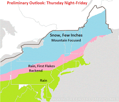
Good morning. I do not have many changes for the wave of snow that will impact interior New England tomorrow night. This will not be a big deal as most of the accumulations will be in the Mountains per my map. Other areas see a coating. For the NYC metro its just some rain. There is a CHANCE the mountains of NW NJ (1000ft+) see first flakes with this at the tail end.
The focus then turns to a potential winter storm early next week. I showed you guys earlier this week the "players" that could be involved in producing this storm. Although it is far from set in stone, the potential is still there and today we will take a closer look. Regardless, cold air that is a month ahead of schedule arrives this weekend into next week with temps in the 30s.
Breakdown:
For tomorrow night, here is my map. I made no changes from yesterday. Expect 2-4 inches for the mountains and a coating elsewhere in the blue area. There is the outside chance a few areas at higher elevations on the nw edge of the green zone see first flakes.
Here is model projection for tomorrow night into early Friday, notice hints at some flakes in NW NJ at the back end...
Very cold air then follows for the weekend with lows in the 20s highs in 30s to low 40s...
We then turn our attention to the storm threat for next week. Here was my original image illustrating this threat from Monday...
To examine this further, lets take a look at the jet stream and what can come together to produce this storm...
The key here is do the two jet streams labeled above come together along the east coast. If they do there is enough cold air in place to produce an early season winter storm in the red circle area. I also labeled a key factor here that "high pressure ridge" in the atlantic. This helps steer the storm up the coast. Depending how how strong this ends up being will determine if we have a storm that comes up the coast. This is the most unclear detail at this time.
As an example look how the models have shifted last few days with the sharpness of this high pressure ridge...
Notice in the last few frames how the model has sharpened the ridge out in the Atlantic.
At this surface this is what that does. Notice the storm pop up...
So you can see the factors we need to watch here. As I said on Monday they are all on the table its just if they come together.
If we think about this logically (which in weather terms doesn't always mean it ends up right) the overall air pattern early next week features a very cold air mass and a warm ocean...
One would think that a storm would want to form on the boundary between the warmer air off the coast of the Atlantic and the cold air that is bleeding into the country. This would mean a storm that comes up the coast.
In terms of areas to watch for early next week for snow IF this develops, I think are represented best by this map below which uses historical analogs (similar atmospheric setups) to project impacts...
Given the impressive nature of the air mass I would say even the NYC metro and all of coastal New England have a shot here. for Southern NJ into DE and MD I would not count on it.
We got something to track here! Lets see if it comes together. Daily updates to come.


I finally found a broker about which for the first time in 5 years I will write a positive review. sure traders Group company really showed its good side. This is both reliability in the execution of orders, and professional consultants who will always come to the rescue if force majeure suddenly happened on the market, I have no complaints about the trading platform, it works perfectly and does not freeze. With the depositing and withdrawal of funds in general there are no problems, everything comes on time. And of course, webinars which are conducted very often, for beginner traders and if you want to recorver your lost funds - I recommend expert.traders4u@gmail.com, although for those with experience too. In general, for four months I have no complaints about the company. you can whatsapp them on +263787350597 Email.... [expert.traders4u@gmail.com].
ReplyDeleteHello everyone..Welcome to my free masterclass strategy where i teach experience and inexperience traders the secret behind a successful trade.And how to be profitable in trading I will also teach you how to make a profit of $12,000 USD weekly and how to get back all your lost funds feel free to email me on( brucedavid004@gmail.com ) or whataspp number is +22999290178
ReplyDelete