Summary:
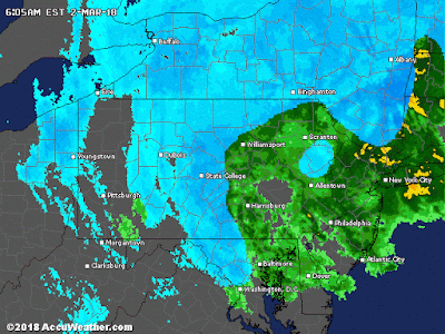
- Conditions rapidly deteriorate this morning with heavy rain changing to snow (darker colors regions earlier, light blue this afternoon) and very high winds
- Peak of the storm late this morning through the afternoon
- Expect heavy snow for darker regions
- Winds will gust over 60 mph on the coasts and over 40 mph inland
- For the higher elevations of NW NJ,PA I expect a significant snowfall from this on the order of 6-12"
- whiteout conditions at times
- For NYC I expect a few inches possible on the back end later today
- The same goes for most areas in the light blue zones
- When its all said and done this storm might make history due to the impacts it will have on the coasts with high winds and surf
Current water vapor shows the monster developing rapidly off the coast...
We are already seeing heavy snow in NY state and snow breaking out in the Poconos as of 6am...
Our current low is rapidly intensifying off the coast as seen by the small circle..
The pressure level is 986 and rapidly falling
Latest models show a rapid changeover to snow as the storm strengthens and pulls down cold air from aloft. This image is from 6am to 11pm ....
You can see the rain mixing with snow in NJ. Most accumulations will be at higher elevations**
The wind forecast for max gusts is very intense...
Orange areas are gusts over 50mph possible. Red areas near the coast are gusts over 60mph if not 70mph in local spots. Not a good coastal scenario!
In terms of higher resolution snowfall chances, the map below shows the higher elevations that can see the localized heaviest snowfall amounts...
If you live in these brighter areas, this is an all out snowstorm by mid morning.
Stay tuned, updates to come!


The early-March weather lion is now roaring !!
ReplyDeleteEven at this point (about 8 am), when the storm is in its 12th hour over NNJ, the models are STILL all over the place as to what happens with lower and upper air temps, rain / snow changeovers, wind speeds and when the precip ends. Some say by 6pm, others have it going strong thru midnight. Usually don't see so much model divergence in the middle of a storm event. But I guess that the negative NAO / Greenland block situation, along with the polar vortex still sorting out the sudden Arctic strat warming from last week, throws a lot of chaos into the weather dynamics. Gotta just sit and watch, see what happens; this one may still have a few surprises one way or the other. Jim G
This comment has been removed by the author.
ReplyDelete3"+ already on grass in Concordville, PA and many covered roads. Your earlier guess was on the mark. Maybe draw wildcards for the next prediction. ��
ReplyDelete