Welcome to the first day of Meteorological Winter!
Summary:
- Arctic air moves in on Thursday
- This air stays locked in for the core of December
- Winter will be in full swing!
- Best chance at any snow is between the 8th and 18th of December
- Whether it is a big storm or lighter events remains to be seen
- For a bigger storm we need to see the cold air not press too hard
- The chances of a White Christmas are higher than normal this year
Good morning. Hope everyone is going to be enjoying this nice stretch of weather over the next few days because things will take a drastic turn later next week. When it is all said and done this does have the potential to be a memorable December. In model land it couldn't look more perfect, now we just need reality to match it. I have spoke about this in length over the last week or so, so lets focus now on how long this cold will last and also if it will snow.
As I have shown the big arctic front moves in on Thursday...
Temperatures crash into the 30's for highs by the weekend and winter will be in full swing. The question is now twofold. How long will this cold last and when will it snow.
Lets start with the ladder first. Anytime you have these big arctic fronts moving in, you always have to look for snow on their tail.
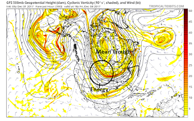
Looking above this will be the pattern at 18000ft by the end of next week. This shows energy in the atmosphere. The passage of the arctic leave a broad based trough or mean trough over the east which locks in the cold air (this trough also stays locked due to high pressure over Greenland -NAO pattern). These mean troughs then have impulses of energy rotate around them. IF a impulse is sharp or strong enough it can cause a storm to develop.
In this case, I circled an area of energy that we have to focus on (below). This energy will move around that trough similar to how a car moves around a track. If it stays spread out and flat then you do not get much of anything. However if it is sharper and more dynamic you can get a coastal storm to develop. Yesterday's GFS model showed the energy in the above image but much sharper as seen below....
The result was a surface response that spun up a winter storm....
So what do I think? I am not very bullish on the above outcome. Anytime we get these big troughs to swing through it needs to amplify perfectly to cause what you see above. In many cases its a colder drier pattern. OR if a storm does develop it will tend to stay more south.
HOWEVER, as the cold air relaxes just a little we then have, in my opinion, a better shot at a real storm. This could occur sometime the following week (week of the 10th). Remember my target period for our first snow was the 8th-18th.
Now to the cold air. It looks like the pattern is a lock heading into the core of December. I base this on updated long range modeling and also the historical analog years that are now matching up the closest to what the current observations are. This means the chances of a white Christmas are higher than normal this year!
So lets see how this plays out. We will watch the end of next week for a storm to spin up, but I still am more bullish on the period to follow.
Stay tuned!


the best part about Willy's analysis is the specificity. I can't stand the professional "METS" on Twitter who call themselves "BEST NORTHEAST WEATHER EXPERT" and make some dramatic tweet about a "big storm in the Northeast" without specifying if it'll affect NJ or New Hampshire. Most people who follow weather on Twitter are laymen who are looking for simple forecasts with a bit of easily digestible science which I think Weather Willy provides.
ReplyDeleteThank you! Appreciate it.
Delete