The storm currently is approaching Turks and Caicos islands and is maintaining its strength...

My original expected track from a few days ago was this...
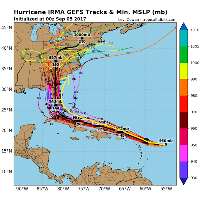

Anyone down in these areas please use the National Hurricane Center to make decisions. Remember I and not a pro and do not do this as a full time job.They have adjusted their track more east in last 24 hours however so I am not far off from what they now have...

I expect this storm to have major major impacts on the east coast of FL along with the coast of South Carolina and Northern Georgia. We will not fully know how bad the conditions will get until about 48 hours before but all signs point to historical impacts. As an idea, here is the projected wind field as the storm moves in from the GFS model. I am using the GFS because it is the closest to what my ideas have been...

Those pink and dark red areas near the center are winds easily over 115 mph and can be much greater. Remember this track is not a lock, any west or east movement puts all of FL and all of the SE coast at risk. This model will shift around! In terms of the pressure level seen that is sub 900, I do not think it gets that low. I will say however sub 920 is not out of the question due to the extremely warm water in this region...

So is there a risk this trends more west or east? At this time I think the trend would be more east if we had to speculate, although I factored all thinking into my current forecast. Where things can go wrong is as usual based on the upper air pattern...

We have multiple components steering this storm. I have discussed many of them over the last few days but this is all of them on one page.
I will start doing video discussions this weekend along with my morning commentary. Stay tuned.
This comment has been removed by the author.
ReplyDelete