Saturday, September 9, 2017
Saturday Night Video Update: Irma on Its Final Approach
My latest video discussion breaks down Irma as it makes it northerly turn towards a Florida landfall. This storm will be as strong as expected and everyone at this point should be fully prepared. I will be tracking this as it makes its landfall tomorrow morning.

Saturday Morning Update: On Track, Eastern Florida Gets Crushing Blow...Video Tonight

Good morning. Irma is currently barreling through Cuba and is about to take a turn north towards Florida. Latest winds have weakened due to interaction with Cuba but do not be fooled! This will strengthen again as it makes it turn north towards the Keys and eastern FL. I expect a Cat 4 at landfall.
The outer bands are already starting to impact southern Florida as seen by the radar...

Here is updated NHC track, nothing has changed much just a nudge west...

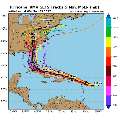
Here are updated model projections...


Below in my previous post is a video I cut last night breaking this down. I will have another video update tonight between the 6-9pm time frame as Irma makes her final approach into Florida. It will be interesting to see how it re intensifies once over the open water again. A lot to follow!
Stay Tuned!
Friday, September 8, 2017
Friday Night Video Discussion: Irma Making a Beeline Towards Florida
My latest video discussion breaks down what to expect for this historical and massively destructive Hurricane. The power of this storm truly is remarkable.
Friday Hurricane Update: Track Adjustments Being Made
Good morning. We are now getting into crunch time when it comes to tracking Hurricane Irma and its impacts to the US coast. This storm will be absolutely historical and unfortunately leave a big path of destruction in its wake. Based on observations and latest model data I have made updates to my original track and will explain why below. But first, here she is...

The storm is really not weakening at all and maintains a scary structure as seen above. Current winds are at 160mph+. I do not see too much of a weakening trend in its future here. The water is too warm and the upper atmosphere is favorable.
I have made adjustments to my track. Here is my new map...

Notice the shift I made west. Although we have data indicating this can still be on the eastern side (edge of my red cone) the observations I am seeing back up the western models. The National Hurricane center is similar...
 The american model suite is a little more east of all of this....

This was more in line with my original track but I think it is now wrong. The next image shows the storm positions vs the american models projections over the last few days....

Notice all the lines are basically north of the actual storm positions. This is showing us that the American model has been too far north with its projections so far. The result of this was an earlier turn in the Hurricane hence the more eastern track. If this trend continues it is a warning sign that the American model is making an error.
The European and British models have been more west and have held their ground. The next image shows the European models ensemble system track...
 You can see the westward impacts shown above. I adjusted this slightly east to make my map but the idea is clear, all of FL needs to be prepared for a direct hit.
Taking a closer look at impacts, here are projected sustained wind speeds at landfall. I warn we need to still wait 24 hrs to know the exact magnitude of strength but regardless it will be a powerful blow...

Image below shows landfall early Sunday morning with sustained winds of around 130 mph for the Keys into Southern FL. Just a devastating scenario.
The storm will weaken as it travels up Florida but not fast enough for the whole central and southern part of the state. Below shows the wind field as storm moves up coast...

I can not stress enough how impact this Hurricane will be. Today is critical for watching things evolve and lock in on the exact impact zones. I am interested to see how strong this gets once it starts its right turn towards Florida.
Special video breakdown tonight at 830 pm. Stay tuned.

The storm is really not weakening at all and maintains a scary structure as seen above. Current winds are at 160mph+. I do not see too much of a weakening trend in its future here. The water is too warm and the upper atmosphere is favorable.
I have made adjustments to my track. Here is my new map...

Notice the shift I made west. Although we have data indicating this can still be on the eastern side (edge of my red cone) the observations I am seeing back up the western models. The National Hurricane center is similar...


This was more in line with my original track but I think it is now wrong. The next image shows the storm positions vs the american models projections over the last few days....

Notice all the lines are basically north of the actual storm positions. This is showing us that the American model has been too far north with its projections so far. The result of this was an earlier turn in the Hurricane hence the more eastern track. If this trend continues it is a warning sign that the American model is making an error.
The European and British models have been more west and have held their ground. The next image shows the European models ensemble system track...

Taking a closer look at impacts, here are projected sustained wind speeds at landfall. I warn we need to still wait 24 hrs to know the exact magnitude of strength but regardless it will be a powerful blow...

Image below shows landfall early Sunday morning with sustained winds of around 130 mph for the Keys into Southern FL. Just a devastating scenario.
The storm will weaken as it travels up Florida but not fast enough for the whole central and southern part of the state. Below shows the wind field as storm moves up coast...

I can not stress enough how impact this Hurricane will be. Today is critical for watching things evolve and lock in on the exact impact zones. I am interested to see how strong this gets once it starts its right turn towards Florida.
Special video breakdown tonight at 830 pm. Stay tuned.
Thursday, September 7, 2017
Stay Tuned for Frequent Updates
Updated track and video discussions will be out tomorrow and continue throughout duration of this event. Stay tuned.
Thursday Hurricane Update: Honing In On The Track
Good morning everyone. As Irma draws closer to the United States we can now start to really hone in on what this track is actually going to look like. Forecasts can now be made but as always I think this storm throws us a few surprises right until the end.
The storm currently is approaching Turks and Caicos islands and is maintaining its strength...
 Latest readings have a pressure of 921 mb and wind speeds of 178 mph.
My original expected track from a few days ago was this...
 I have drew a map with my updated thoughts which have not changed much. Impacts for southern zones start Friday night..

Anyone down in these areas please use the National Hurricane Center to make decisions. Remember I and not a pro and do not do this as a full time job.They have adjusted their track more east in last 24 hours however so I am not far off from what they now have...

I expect this storm to have major major impacts on the east coast of FL along with the coast of South Carolina and Northern Georgia. We will not fully know how bad the conditions will get until about 48 hours before but all signs point to historical impacts. As an idea, here is the projected wind field as the storm moves in from the GFS model. I am using the GFS because it is the closest to what my ideas have been...

Those pink and dark red areas near the center are winds easily over 115 mph and can be much greater. Remember this track is not a lock, any west or east movement puts all of FL and all of the SE coast at risk. This model will shift around! In terms of the pressure level seen that is sub 900, I do not think it gets that low. I will say however sub 920 is not out of the question due to the extremely warm water in this region...

So is there a risk this trends more west or east? At this time I think the trend would be more east if we had to speculate, although I factored all thinking into my current forecast. Where things can go wrong is as usual based on the upper air pattern...

We have multiple components steering this storm. I have discussed many of them over the last few days but this is all of them on one page.
I will start doing video discussions this weekend along with my morning commentary. Stay tuned.
The storm currently is approaching Turks and Caicos islands and is maintaining its strength...

My original expected track from a few days ago was this...

Anyone down in these areas please use the National Hurricane Center to make decisions. Remember I and not a pro and do not do this as a full time job.They have adjusted their track more east in last 24 hours however so I am not far off from what they now have...

I expect this storm to have major major impacts on the east coast of FL along with the coast of South Carolina and Northern Georgia. We will not fully know how bad the conditions will get until about 48 hours before but all signs point to historical impacts. As an idea, here is the projected wind field as the storm moves in from the GFS model. I am using the GFS because it is the closest to what my ideas have been...

Those pink and dark red areas near the center are winds easily over 115 mph and can be much greater. Remember this track is not a lock, any west or east movement puts all of FL and all of the SE coast at risk. This model will shift around! In terms of the pressure level seen that is sub 900, I do not think it gets that low. I will say however sub 920 is not out of the question due to the extremely warm water in this region...
So is there a risk this trends more west or east? At this time I think the trend would be more east if we had to speculate, although I factored all thinking into my current forecast. Where things can go wrong is as usual based on the upper air pattern...

We have multiple components steering this storm. I have discussed many of them over the last few days but this is all of them on one page.
I will start doing video discussions this weekend along with my morning commentary. Stay tuned.
Subscribe to:
Posts (Atom)