Summary:
- A rainy Halloween is on tap with maybe a break in the rain around trick or treat time
- Cold air follows for this weekend
- By middle of next week a more impressive cold shot arrives
- I expect snowfall in interior New England mountains
- This cold shot could linger for the 1st half of November
Starting off, we have some more rainy weather to deal with as we head into Halloween. Today will be cloudy with more drizzle then we have a storm system to deal with starting tomorrow morning...

There may be a break in the rain by the evening before the final batch comes through later tomorrow night. Regardless, not the nicest day.
A cold front then arrives in the wake of this storm tomorrow for the weekend...

This will be a very noticeable cool down with temperatures dropping into the 30's at night and only low to mid 50's during the day. Many areas may not even see temperatures leave the high 40's on Sunday.
Things then moderate a little then the bigger cold pattern moves in for the middle of next week....
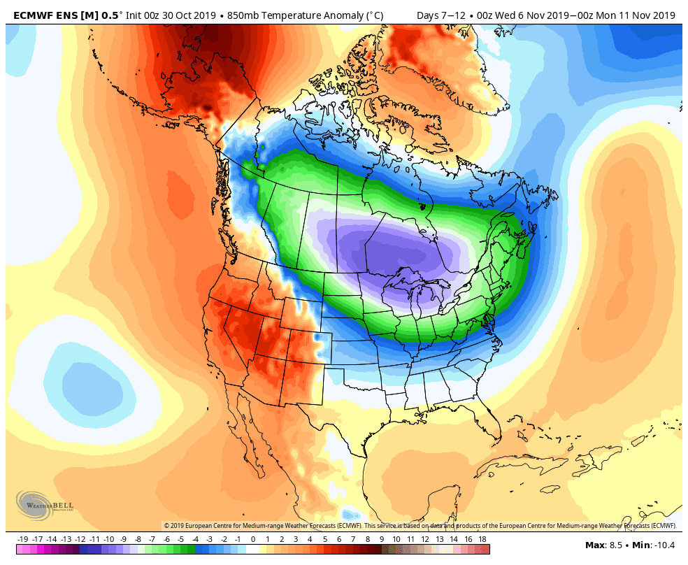
This will mark an official pattern change from what we have been used to over the last 2 months. What this means is that I believe the cooler than normal weather is here to stay for at least the first half of November. You can see above the cold air directly funneling down from Canada. I have been watching this situation for a week now and am confident how the models are handling things.
To draw a contrast, here has been the weather pattern over the past month...

Warm colors show warmer than normal conditions. Notice the cold pool out west.
The pattern next week flips to the opposite...

So many factors I love to see in image above which is valid for Nov 6th-11th. We have a area of low pressure south of the Aleutian Islands (misspelled on image) which in turn drives up a ridge of high pressure over the west coast (+PNA pattern). This allows cold air from Canada to pool near the east coast. This is the exact pattern we need to see repeat this winter if you want cold and snow.
In fact, the mountains of New England do see snow next week in my opinion. The model means are showing this...

In terms of temperatures region wide. Expect low temperatures in the low 30's to upper 20's and high temperatures in the mid 40's to lower 50s when the core of this pattern moves in.
I do not see any outside factors that indicate to me the models are wrong with this pattern projection. I usually look at thunderstorm activity in the tropics and Indian ocean but over the next 10 days that activity will be limited factor in fighting against thing pattern. Thus my confidence level is high.
By mid November things can ease up a little before a potential reload as we get into December. I am thinking the "reload" may take some time and December could end up starting mild. We will see.
I finally found a broker about which for the first time in 5 years I will write a positive review. sure traders Group company really showed its good side. This is both reliability in the execution of orders, and professional consultants who will always come to the rescue if force majeure suddenly happened on the market, I have no complaints about the trading platform, it works perfectly and does not freeze. With the depositing and withdrawal of funds in general there are no problems, everything comes on time. And of course, webinars which are conducted very often, for beginner traders and if you want to recorver your lost funds - I recommend expert.traders4u@gmail.com, although for those with experience too. In general, for four months I have no complaints about the company. you can whatsapp them on +263787350597 Email.... [expert.traders4u@gmail.com].
ReplyDelete