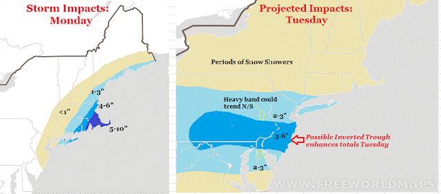
- Storm 1 brushes by area tonight, hits eastern New England with Snow
- Several inches will fall up there
- Storm 2 hits area Tuesday but will be more focused on a narrow area (more below)
- Area that is in the narrow band can see 6+ inches due to something called an inverted trough developing
Here are my impact maps for Monday and Tuesday:
For Tuesday, this whole forecast depends on an inverted trough developing over the area. Without going into too much detail an inverted trough results in a narrow band of heavy precipitation possibly developing. I tried to indicate where I think that will occur as seen by the 3-6" zone Tuesday. Fair warning, this is very volatile and could shift north or south! Regardless, who ever gets into that heavier snow will see several inches fall.
My quick 2 min video below breaks down this forecast. I suggest you watch for easy to understand details. More on twitter today and blog update tomorrow morning..

No comments:
Post a Comment