Here is the bottom line:
- Big storm impacts the area next week
- Recent trends in models have moved towards a warmer storm closer to the coast
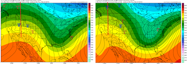
- This is due to a ridge axis out west that is not in the right spot.
- If this verifies it means rain for areas in the Mid-Atlantic and snow for interior New England
- This is far from a lock, it is a very complicated set up and things will still change over next few days.
- There is also the chance for a surprise snow event Sunday night into Monday morning for northern counties
- models are split on this idea
- I will cover this tonight if there is more agreement on this
- I will have a preliminary forecast out this weekend for Wednesdays storm
So basically when I look for factors that would drive a big winter storm in the east I want to see:
- Ridge axis near Montana
- Blocking ridge over Greenland
- High pressure locked in place by a 50/50 low
- A trough that goes negative near the coast
Based on the trends in the latest European Ensemble we have NONE of the above..
I really hope I am wrong here but the data does not lie. This has inland runner written all over it. In fact, look at the massive sift in the European ensemble ridge position over last 48 hours..
Old run from 48 hrs ago on left new on right. If that is not a clear trend then I do not know what else is. Notice the where the low is on both images.
At the surface it would look something like this..
What a crushing blow for snow lovers that would be. Look guys maybe I am being too pessimistic here considering we got 5 days to go and a very complicated set up. I know this is going to change. My point in today's post is that the trends have been in the wrong direction. If you want snow, you need new trends to now develop back the other way next 24 to 48 hours. I will start to release my actual forecast ideas this weekend with impact maps etc.
As far as Sunday night this would be the best case scenario for snow below in northern counties. Not all models agree on this yet..
As far as Sunday night this would be the best case scenario for snow below in northern counties. Not all models agree on this yet..
Thanks for reading. I will have an update tonight.


No comments:
Post a Comment