Good morning everyone. No need for the alarm clock today, the chirping birds woke me up. Is this a sign that things are over? Well no, the birds alone do not mean anything but the weather yesterday might. I can't remember the last time I saw 65 degrees with thunderstorms at the end of February. Very depressing for a winter weather lover.
This is pretty close to the end here guys. We got two weeks where maybe something can click and we get one more shot at a storm, but I am starting to lean in the other direction. If this was 100 years ago and we had no weather models I think common sense would rule here.
However, March is notorious for curve balls when it comes to winter weather. Let's not forget in the blizzard of 1888 it was in the 60's in NYC the day of the storm! With the projected pattern over the next 10 days something can click and we can get lucky. If we do not well, lets just say I am not getting my hopes up for anything at this point.
So to the pattern..
Middle to end of next week a storm should develop. Here is the upper air set up..
We have a block in place a ridge out west and energy diving into a trough in the east. However, this could also be rain if that energy consolidates too soon. I do not like seeing ridging off the east coast. Not too optimistic on this threat at this time.
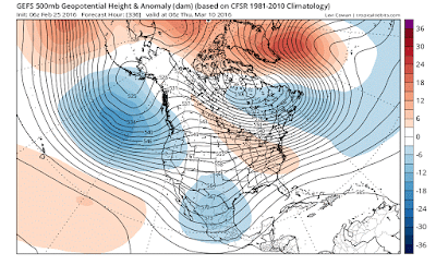
From there we go to the following week which could really be the last hurrah..
This image above valid for around March 10th might be interesting. If we see the red over Greenland and the blue near coordinates 50/50 then we might have a situation where cold air is locked in place along east coast and sub tropical moisture gets thrown into it. You can see the sub tropical energy in blue over Mexico and Texas.
Thats all for today. I just wanted to set the stage for potential storm threats we need to track- middle of next week and middle of the following week.
Thanks for reading.


Willy, yea, I'm thinking March 8 - 12 is your zone of possibility. The MJO forecasts are in zone 8 at that point, good for an eastern trough. But it will be weakening, headed into the circle of insignificance by mid-month. The various NAO forecasts are looking for a roughly neutral situation around the 10th, maybe even slightly negative. Which might allow for your 50-50 low, blocked up in Greenland. The AO could well be negative at that point, so the vortex and northern stream could be quite loopy over N America. The 10mb polar strat temp took a noticeable jump today, so a new round of strat warming could be under way. However, the 1000mb polar temps above 80 lat are now averaging around 0F, starting to go positive; spring fever will soon be in the polar air. Your biggest problem looks to be the Pacific, you may have lost the strong + PNA by that time, might be close to neutral, and the EPO could be + at that point. So you might not have all that much big ridge support in the west; residual Nino energy in the Pacific might get into the zonal flow. It's gonna be tight -- if all of the cycles just happen to come together constructively, we could have some plowing and shoveling to do. Worth watching. Otherwise, time to get the gardening tools ready. Jim G
ReplyDelete