WINTER OUTLOOK 2023 IS NOW LIVE

The 2023 Winter Outlook

Wednesday, October 30, 2019

Wednesday: Cold Pattern Incoming 1st Half of November

Good morning. We have our first real cold pattern of the season scheduled to arrive next week. I started to touch on this Monday and I wanted to go into a little more detail today.

Summary:


  • A rainy Halloween is on tap with maybe a break in the rain around trick or treat time
  • Cold air follows for this weekend
  • By middle of next week a more impressive cold shot arrives
    • I expect snowfall in interior New England mountains
  • This cold shot could linger for the 1st half of November
Starting off, we have some more rainy weather to deal with as we head into Halloween. Today will be cloudy with more drizzle then we have a storm system to deal with starting tomorrow morning...


There may be a break in the rain by the evening before the final batch comes through later tomorrow night. Regardless, not the nicest day.


A cold front then arrives in the wake of this storm tomorrow for the weekend...


This will be a very noticeable cool down with temperatures dropping into the 30's at night and only low to mid 50's during the day. Many areas may not even see temperatures leave the high 40's on Sunday. 

Things then moderate a little then the bigger cold pattern moves in for the middle of next week....


This will mark an official pattern change from what we have been used to over the last 2 months. What this means is that I believe the cooler than normal weather is here to stay for at least the first half of November. You can see above the cold air directly funneling down from Canada. I have been watching this situation for a week now and am confident how the models are handling things. 

To draw a contrast, here has been the weather pattern over the past month...

Warm colors show warmer than normal conditions. Notice the cold pool out west.

The pattern next week flips to the opposite...


So many factors I love to see in image above which is valid for Nov 6th-11th. We have a area of low pressure south of the Aleutian Islands (misspelled on image) which in turn drives up a ridge of high pressure over the west coast (+PNA pattern). This allows cold air from Canada to pool near the east coast. This is the exact pattern we need to see repeat this winter if you want cold and snow.


In fact, the mountains of New England do see snow next week in my opinion. The model means are showing this...


In terms of temperatures region wide. Expect low temperatures in the low 30's to upper 20's and high temperatures in the mid 40's to lower 50s when the core of this pattern moves in. 

I do not see any outside factors that indicate to me the models are wrong with this pattern projection. I usually look at thunderstorm activity in the tropics and Indian ocean but over the next 10 days that activity will be limited factor in fighting against thing pattern. Thus my confidence level is high.


By mid November things can ease up a little before a potential reload as we get into December. I am thinking the "reload" may take some time and December could end up starting mild. We will see. 

Monday, October 28, 2019

Monday: The First Real Fall Cool Down Comes after Halloween

Good morning. As we put October almost behind us, we now will start looking at what the weather pattern will look like as we start November. 

Starting with Halloween, temps will warm up this week as we approach the holiday and unfortunately a storm system will be cutting to our west on Halloween...

This means a rainy day for trick or treaters. 

In the wake of this storm the first real cold shot of the season come in for the 1st week of November...


The brunt of it will be centered on the central states, but it does bleed east this time.

This means by next weekend/early next week high temps will be in the 50s and lows in the 30s for most areas. It will be colder in New England.

There is the chance that we even see high temps in the 40s with an air mass like this so it bears watching. I also expect some snowfall in the New England mountains and lake effect regions with this air mass next week. 

I still question how long the cooler pattern stays in place after the 1st week of October. Long range models are showing some consistency with a vortex of low pressure trying to sit over central/eastern Canada which does usher in a winter type pattern. However, the pacific needs to behave and we need to see where the ridging and trough relationship sets up...


We will have to monitor this closely. I am not sold yet and honestly do not want too much winter type potential this early as in the past its meant low snowfall winters. Lets save it for December. 


Stay tuned. 

Thursday, October 24, 2019

Thursday: Halloween Outlook

Good morning. As we head towards next week, there is some disagreement on the placement of the next cold shot from Canada around Halloween. 

The GFS ensemble has been the most aggressive by bringing the cold shot to the east...


The European Ensemble has been consistent in saying the east stays out of the core of the cold and has things quite mild with that southeast ridge.


The Canadian ensemble is a similar to the GFS...


So whats the verdict? An impressive cold surge will enter the central US next week as that massive ridge (red area) over Alaska (quite impressive by the way) blocks any pacific air from entering the pattern. However, I do believe given the seasonal trends the cold air stalls as it heads east due to influence from our stubborn southeast ridge. This means I expect seasonable conditions for the east for Halloween with impressive cold for the central United States.


As we enter the longer range I expect we do see our first impressive shot of cold air the 1st week of November. This could mean mountain snows in New England. However, that southeast ridge will continue to fight back so cold shots will not be very sustainable. This process will continue into the winter but I think starts to breakdown by mid-winter were more sustainable cold shots are likely.

More to come.

Monday, October 21, 2019

Monday Long Range Outlook: Winter Pattern Emerging?

Good morning. As we now enter the colder months of the year, we will start to speculate on what the long range weather pattern has in store. Per my winter outlook (see tap on top of page) last week, I discussed how I thought this would be a very active winter for the country overall but we would see an influence by the southeast ridge which can keep things a little tamer in the Mid-Atlantic states for at least the first half of winter. 

As we enter late October into early November the pattern developing isn't too far off from what I am expecting. Granted, we are not in winter yet and a lot can change but it is interesting to observe.

By next week, we will see a pattern that involves impressing blocking over Greenland and off the West coast...


This will drive very cold air from Canada into the central United states and bleed east for late October. Notice the warmer than normal over the southeast...


Kinda looks like my temperature outlook...


Again, this is not winter so this comparison doesn't really mean much. My only point is that sometimes we see flashes in autumn what the winter pattern may look like. 

So in summary, for those of us in the NYC areas into New England expect some nice shots of cool air filtering through the region next several weeks. As you go further south expect things to stay on the warmer side for this time of year with a few autumn chills in between.

It is going to be very interesting to see if and when this stubborn Southeast ridge breaks down this year. If it does then areas further south see more winter action. If it does not then its more of a winter for the interior northern mid-Atlantic into New England per my forecast. 


Friday, October 18, 2019

Blog Season Starts Monday

That means more frequent posting as we step down into winter. In the meantime, enjoy the winter outlook below.

Tuesday, October 15, 2019

The 2020 Winter Outlook

Welcome to the 2020 Winter Outlook! It is always a fun time of year when I begin to speculate on what will happen for the winter season ahead. I will be the first to admit, trying to forecast what may happen in a winter can be a fools errand at times, but there are years where my research and ideas have panned out. So lets jump in and take a look at what to expect for this upcoming season.

The outlook is broken into two sections:

  • Section 1: Summary of the Forecast
    • Simple and easy to read breakdown of what I am expecting this year
  • Section 2: Details behind the forecast
    • For those who want to see the methodology

Forecast Summary:

The Winter of 2019-2020 should feature activity from coast to coast this year. I expect an active track of storm systems that will vary from the impacting the Rockies and Midwest to the Mid-Atlantic and Northeast. This means very good ski seasons up in New England and out west. However, due to the nature of the storm tracks, I think areas like the Mid-Atlantic run into frequent situations this year with mixed precipitation as storms redevelop from the interior to off the coast. This means snowfall totals in those areas will range from below average from the southern Mid-Atlantic (Baltimore areas) to slightly above average for the northern Mid-Atlantic (NYC areas). Further to the north I expect an excellent season in terms of snowfall (Boston metro, Burlington).

In terms of temperatures, expect a wide area of average winter temps from the central west into the Mid-Atlantic. I do think the Southeast and southern Mid-Atlantic battles warmer than normal temps for at least a part of this winter season. This is a theme that has been frequent all year and I think it is here to stay through January. For the northern plains and New England, I expect below normal winter temperatures with the core of the cold over the northern plains. There will be some impressive cold shots this year that will rival years past. At times these cold shots will work into the Mid-Atlantic and even Southeast. 

It is hard to nail down when winter will really kick in this year. I am thinking that December is a slow month overall and winter really kicks in by the time January comes along. We may see a few impressive cold shots again in November like last year, but my research is suggesting things may back off again by December. This is the most uncertain part of the forecast.

Impact Maps (click to make bigger):


To help everyone know what average vs above average snowfall for your area, see map below (click to make bigger):


Forecast Details:

For this year I used a combination of analogs (past years that had similar atmospheric setups), long range models and observations to make the forecast. I looked at each piece independently then blended the ideas together to develop the forecast.


Analogs:

The current state of sea surface temperature anomalies in some ways is unique to only recent years. This is due to large areas of above normal ocean surface temperatures especially in the pacific.

See current ocean temperature breakdown...

 
Years in the past that I have found to a similar blend of these sea surface temperatures are below...


It is not perfect, but it hits the overall theme decently well especially in the tropical pacific.

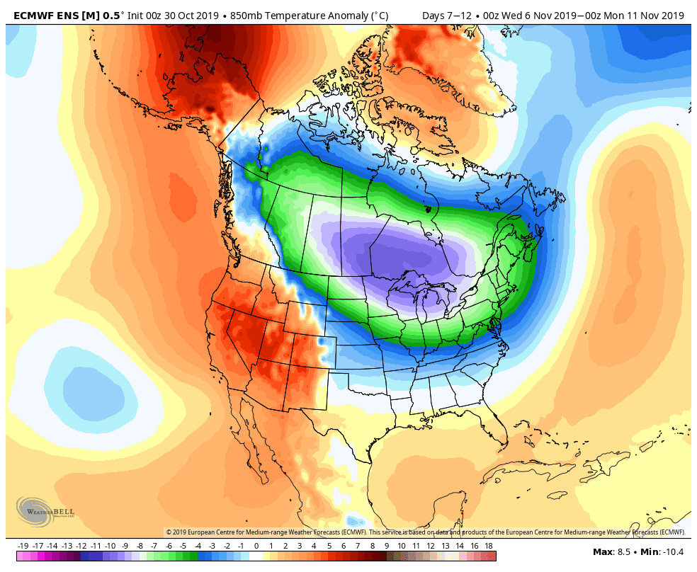
These years blend out to this projection of winter 500mb Heights and 850mb temps...


Which is not too different for years that have ENSO neutral conditions overall...

I even took a look at the top 3 analogs and that resulted in this at 500mb...


As you can see these finding suggest an active winter with cold focused in the central states bleeding over to the northeast.


Models:

Here are the top models I looked at...


European


UKMET

JMA


CFSv2


As you can see they all differ to a degree. However a common theme (exception of the CFS) is to have a colder pool potentially develop in the central states with a southeast ridge fighting against it. If I compare this to my analogs and bring both components closer to each other (average out) we end up with cold air pressing from west to east this winter with a storm track along a fluctuating southeast ridge. Now I think as winter matures this southeast ridge can die this year but for first half of the season I think it takes its toll for areas further south in terms of mixed precip and rain as storms approach. 

Observations:

Snow Cover over Eurasia-

Research has suggested that in years where snow cover is above normal over Eurasia it can lead to a negative phase of the Arctic Oscillation due to disruptions of the polar vortex (Dr. Judah Cohen research). This idea has played out decently well historically.

This year snow cover is above normal to an impressive degree...


QBO-

The QBO is a wind pattern in the upper atmosphere near the equator. The winds vary from propagating downward eastward and westward. We currently are in a western phase with easterly winds trying to work down (blue)...

When we see easterly winds (blue) develop and make it down to 50-30mb it can aid in blocking during the winter( high pressure over Greenland). This year it going to be a close call. 


Current Weather Pattern-

There is no denying that over the last 8-12 months the country has seen a persistent southeast ridge of high pressure. This has resulted in record heatwaves for the southern states into south Mid-Atlantic...


Although I do this this can be cut down this winter at times as the season matures, it is hard to ignore what has been so persistent and is right in front of us. I think turning a blind eye to this variable this winter would be a big mistake. 

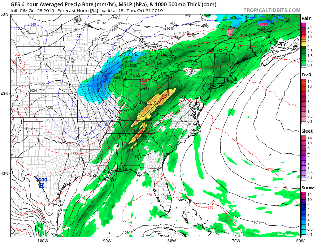
In addition to this, I have been watching storm tracks develop this fall. So far we have seen a big storms in the west central states and will see a big coastal storm develop in the Northeast this week. Sign of things to come? Maybe.

So there you have it, my 2020 outlook. Hope everyone enjoyed the read and I look forward to reporting to you all this winter season!


Monday, October 14, 2019

Outlook Out Tomorrow, Coastal Storm Wednesday

Stay tuned for Winter Outlook 2020!

We also will have our first coastal storm of the season Wednesday. Expect rain and some wind. In New England conditions will be the worst. Some mountain snows are possible if storm really intensifies.

Tuesday, October 8, 2019

Winter Outlook is Out Next Tuesday 10/15

We are 1 week away from my 2020 Outlook...stay tuned!

On another note...a strong offshore Nor'Easter will be developing over the next few days. Expect high winds and surf along coastal New England. This will be a powerful little system.


Will comment more on this if it trends stronger.