Good morning everyone. I wanted to give a quick update on the short and long range. I will elaborate on these thoughts over the next week. Temps will be on the warmer side today reaching near 70! However cold air will come in for the weekend. Highs in the low 50's Friday-Sunday with lows in the 30's for many areas. The pattern then will shift in the longer range. I originally was speculating that November would start off warm then possibly get colder. At this time I can not still support that as we head from November 1-7th. The reason is simple- overwhelming model consensus on a Positive Arctic Oscillation developing. A positive Arctic Oscillation unlike a negative AO means lower than normal pressures near the pole. This locks in the cold air to the north. Diagram below explains:
Now related to that image here are model projections:
Notice all the blue up near the pole, that represents a positive AO and locks the cold air north. I have been watching this last few days and the trends are very strong from all models. Here is an idea of the GFS Ensembles projection of the next two weeks:
Whats the bottom line? I am now very confident that for at least the first 7 days of November we will see warmer than normal weather! Past that period, I will discuss in another discussion.
Good morning everyone. Believe it or not we are already in the last week of October. At this time of year we begin to recognize weather patterns form and hone in on what the winter could bring. In case you missed it, I discussed my thoughts on Winter 2016 last week. You can see a link on the top of the website to that column. Looking ahead to this week, today and Tuesday will start off calm with temperatures in the mid to high 50's. As we get into Wednesday, we will have a rain storm to deal with. This rain storm is a result of moisture originally associated with Hurricane Patricia that hit Mexio late last week. It will ride the jet stream and pass due west of our area Wednesday..
Wednesday will be on and off rain for most of the day. The rain will taper off by early Thursday. This storm will get quite intense once it merges with a digging trough up in Canada, but that will not be our concern. The storm will bring in some temp. warm air for Thursday. Moving on things will cool down a little as we head into to Halloween weekend..
Expect temps to be in the low to mid 50's with colder conditions at night through Sunday. We then approach the long range pattern. I am not going to lie the jury is still out on this. The models keep consisting we get warmer with a trough over the west and a ridge of high pressure over our area..
I agree with this assessment for the first few days of November. However, I do think we see the shot at some more colder than normal weather sometime in the November 5th-10th time frame. In fact, I would not be surprised to see another storm form somewhere in the eastern 1/3 of the country in that time frame. For a more technical discussion on this see below: Right now here are long term model projections for the 5th to 10th period. I edited the map to show what could change with the arrows. Yes, it is speculation of course but after 7 days these models have been all over the place so I am fine speculating..
Right now it is anyone's guess how this long term pattern will evolve. If you just go by the models it looks like a warmer than normal period. However, I am not ready to jump on this yet until I see the model evolution though the middle of this week. Is it wishcasting? I don't think so because like I said I am basing this on how the models handled the peroid we are entering now 10 days ago. They where way off and not to mention we are in phase 2 of the MJO (a pattern that influences the jet stream)..
Which could support a pattern like this..
Compared to the model projections of this..
So as you can see there is reason to be speculative of the models for the long range. More later this week as we track this evolve!
Welcome to my 2016 Winter Outlook. I am expecting another active winter along the eastern seaboard. However, it will be warmer compared to last year. Considering last year was a record breaking cold winter, that doesn't say much. In fact, when you look at my map below you will see I am expecting temperatures slightly below normal. So lets get right into it. Like last year this will be split into two sections:
The bottom line consolidated forecast
For those of you who do not care about the details and just want the know what to expect
The explanation behind the forecast
For those of you who want to understand how I made this forecast
I break many of the factors down in a shortvideo below.
Preface: Results from Last Winter
Here where the results of my forecast last year. On the left where my projected temps on the right where the actual results.
The 2016 Consolidated Forecast
Winter 2016 Temperatures
Slightly cooler= 1-2 degrees below normal
Cold= 2-3 degrees below normal
Warm= 1-3 degrees above normal
Much Warmer= 3-5 degrees above normal
Winter 2016 Snowfall
Note: 1.3x means 30% more snow than normal.
Winter 2016 Jet Stream Configuration
Winter Highlights:
Winter gets off to slow start this year in December.
Cold air then begins to consistently build in the south central and eastern US by Jan and Feb.
There is evidence March could be an active month as well.
It will not snow as frequently as last year.
Much of the above average snowfall will come from 1-2 major coastal storms due to merging jet streams
February will be the coldest month relative to averages and December the warmest month.
Winter will back off at times with mild temperatures giving more relief compared to last year
For skiers, expect another good season up in New England and above average snowfall for the Sierra Nevada's and Southern Rockies.
Here is a map that shows average snowfall for the country if you want something to compare my map to. Click to make it bigger.
Also, average snowfall for NJ- add 15-30% for the snowfall this year
The Detailed Forecast
Every year there are a variety of factors we need to look at when trying to project something as chaotic as mother nature. Those factors include:
El Nino Southern Oscillation
Other Ocean Temperature Patterns
Snow Growth in Eurasia
Stratospheric Wind Patterns (QBO)
Seasonal Modeling
Sun Activity
I listed these factors in the order of their importance for THIS season. There is no question the evolving and potentially record challenging El Nino will drive many of the weather patterns this winter. However, we are seeing an overall set up that we really do not have a historical comparison to as it relates to the overall sea surface temperatures (sst) pattern. Not to mention, every El Nino is unique in terms of the placement of the the warmest sst and the corresponding effect on the jet stream.
In the short video below I outline the methodology of my forecast and discuss the 6 factors above.
Happy Columbus Day! Fall has been in the air over the last week or so, but it will really flex it muscles this weekend as our first big chill of the season will move into the area. Prior to the colder temperatures arriving this week will start off on the warmer side today with temps in the 70's. As we progress towards the weekend those temps will start to fall and bottom out on Saturday night. In fact, we might not see high temps get past 55 degrees for some spots on Saturday. Here is a general idea of the day by day for Northern NJ. Add a few degrees for areas south..
If we breakdown why things are going to cool down, it all comes down to the pattern of the jet stream.
Looking above I highlighted what is going on this weekend. Notice a big ridge of high pressure extending in the west all the way up into Ak. As this ridge pumps, it then allows all the cold air up in Canada to funnel south into the east. This is also aided by more high pressure near Greenland (-NAO) which sharpens the wave in the trough. In fact it just might get cold enough Saturday for snow flurries to the north!
Take a look at low temps Saturday night, many areas will get first frost..
Overall this major cool down won't last long and by early next week temps should moderate back to average. However, this will mark the true end of any lingering warm season weather. On that note, this week I will start writing my 2016 Winter Outlook. Stay tuned the outlook will be released on Monday!
Good morning! Quick post today as it will be a relatively quiet week weather wise. Expect temps in the high 60's and lower 70s with limited chances at any rainfall. A cold front looks like it wants to cross through on Friday which would give us the chance at showers later in the day.
I am expecting colder conditions in the wake of this front. That means high temps in the low to mid 60's possible this weekend along with nighttime lows in the 40's for many places. You are all starting to notice we are going into a fall pattern now. The jet stream is beginning to strengthen (function of larger temperature gradients due to less sunlight in northern hemisphere) so the weather should start picking up in intensity over the next few weeks. In fact we might see our first real shot of cold air mid next week as there are hints the jet stream pattern will dip over our area..
I am going to most likely cover this in more detail later this week but in a nutshell we have high pressure riding along the west coast and over AK with the downstream response of a trough of cold air over the east coast. Again this is for next week. We will also have to keep our eye on any storm development from a pattern like this. More this week. Thanks for reading.
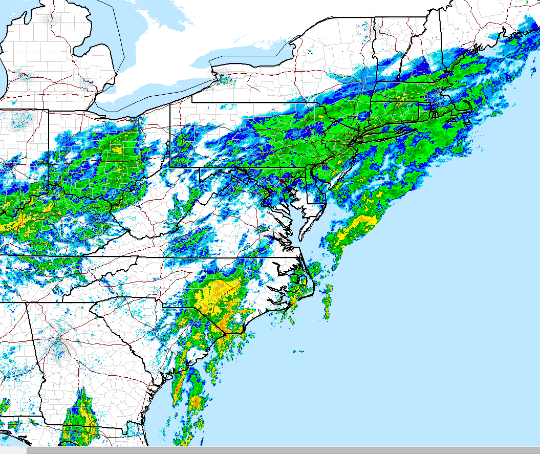
Enjoy your weekend guys!..Hurricane Joaquin has departed land and now will move out to sea where it will eventually die. Don't get me wrong, the storm is currently still a monster (Cat 3 winds 125 mph) but its damage is done and luckily we were spared. The less skillful outlier models have finally shifted to come in line with other major modeling today. In terms of our current storm system rain will continue into tomorrow morning will it will then taper off to showers tomorrow. Remember this rain is not a hurricane. This is the result of a stalled frontal boundary with a tropical connection of moisture. You can see current radar below. The epicenter of this rain is down in SC. They are expected to get over 5". You can see the intense rainfall down there in yellow.
I hope you all enjoyed my coverage this week. Trust me there will be a lot more to come in the weeks and months ahead as we head into the cold season. And don't forget WINTER OUTLOOK 2016 OUT ON MONDAY OCTOBER 19TH!