Enjoy your weekend guys!..Hurricane Joaquin has departed land and now will move out to sea where it will eventually die. Don't get me wrong, the storm is currently still a monster (Cat 3 winds 125 mph) but its damage is done and luckily we were spared. The less skillful outlier models have finally shifted to come in line with other major modeling today.
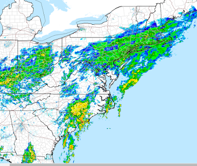
In terms of our current storm system rain will continue into tomorrow morning will it will then taper off to showers tomorrow. Remember this rain is not a hurricane. This is the result of a stalled frontal boundary with a tropical connection of moisture. You can see current radar below. The epicenter of this rain is down in SC. They are expected to get over 5". You can see the intense rainfall down there in yellow.
I hope you all enjoyed my coverage this week. Trust me there will be a lot more to come in the weeks and months ahead as we head into the cold season. And don't forget WINTER OUTLOOK 2016 OUT ON MONDAY OCTOBER 19TH!

According to GFS and other models, Joaquin could still make landfall. But in Greenland, Iceland or Ireland !
ReplyDeleteSeriously, looks like another victory for the Euro. Some weather blogger is going to discuss this under the title "Victory at Sea: Joaquin and the ECMWF". Willy, is it possible that the synoptic models, even the Euro, have different levels of predictive accuracy in different seasons, most obviously winter vs summer? The dynamics of a hurricane and a big snowstorm are rather different, I gather. GFS had a big victory during the winter, ECMWF just had a big victory with a warm-weather storm. Does that tell us anything? (And also the CMC and NAM -- they seem credible in winter, but just don't seem to cut it with tropical storms).
Yes, looks like the UKMET earned some respect here. But once again, is it a "go to" model when you're predicting a blizzard?
Looking forward to the winter report on the 19th. Jim G
I think that is possible, but I am not schooled enough to know the interworking of the models. I do know some of the common bias however like the GFS being too fast with incoming shortwaves during the winter and the Euro being too slow with the southern branch in the southwest. And yeah the cmc and nam are for some reason horrendous with tropical storms. The UKMET i never like to use alone but its good to use as an enhancer to a forecast. For example when the UKMET and Euro agree that's a pretty good sign.
Delete