For some reason those outlier models still want to capture this hurricane from the digging southeast trough..
Since last night the National Hurricane Center has also adjusted their track east..
Given that there still are a few models showing the landfall scenario we really want to wait for this storm to move out of the "capture zone" today before giving the 100% all clear signal. Regardless, the chances of this turning in to shore are less that 20%.
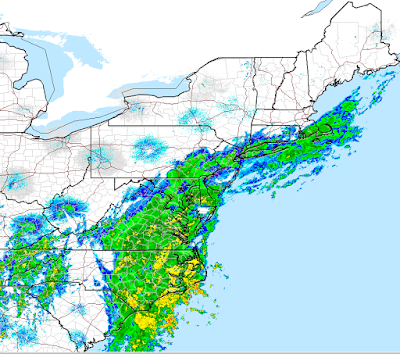
On another note, rain and wind are currently battering most areas of the east coast from our frontal system that is stalled over the area..
Moving into the longer range pattern which I will cover sometime this week, we are looking at seasonable conditions along the east coast over next two weeks with the chance at a few cold shots.
Thanks for checking in. As I said it looks like we are all clear but we want to observe this hurricane completely move out of the "capture zone" before striking up the band.
Quick update later and thanks for reading.


Yup, JQ's turn is looking good, NW at 3 mph at 5 am, 936 pressure (!!!!). 06Z NAM is still in dream-land ("in my mind I'm goin' to Carolina", remember James Taylor?). Interesting that some synoptic models (like NAM and CMC) are relevant in winter, but just don't cut it regarding tropical storms. ALTHOUGH, the 06Z GEFS still has some "renegade" scenarios, including Outer Banks, DelMar, Connecticut (with a close shave off the NJ Coast), and Cape Cod. Hopefully by 12Z it will all pretty much be in synch. Hopefully. The 06Z main GFS run indicates little to no precip here in northern NJ from JQ !! Jim G
ReplyDeleteInsane how bad the CMC, NAM, and Hurricane models are. The GFS was poor too but at least it jumped on the bandwagon sooner. I will say tho Jim do not underestimate the UKMET! It was first to follow Euro. And you know what back for the big NYC blizzard miss last winter UKMET hinted at that too. I think bottom line is when UKMET and Euro agree its a powerful forecasting tool. Thanks for checking in.
Delete