WINTER OUTLOOK 2023 IS NOW LIVE

The 2023 Winter Outlook

Friday, March 10, 2017

Friday Morning Storm Update: Snow Ends Later this AM, Big Storm Chances Increasing

Summary:


  • Snow ends later this morning
    • no changes to my foreacst of a low impact event
  • Big storm next week gaining more traction 
    • Timing is Tuesday morning to Tuesday Night
    • Storm is still not a lock but confidence is increasing
  • Based on my latest analysis I think the storm trends more west not east (see my map below)
    • This means heaviest snow is off the coast
    • Near coastal areas we could see snow changing to a mix if I am correct
  • There are models that are more east 
    • This would mean all snow at coast and less snow to the west of I-95
  • Regardless, someone should see a significant accumulation
    • I will be honing in on this and putting out updated maps over next few days (including accumulations)
  • Update 550pm tonight


Good morning. Big things to talk about for early next week, but before we get there lets take a look at current radar. Moderate snow is moving into NNJ and S NE currently...

Over central and S NJ it is not snowing yet but will change over. As I mentioned, not major impacts from this unless you drive on the grass. I like the snow map I had out yesterday.

Moving on, I have just made my first impact map for the storm potential Tuesday into early Wednesday...

This map is based on what  my initial estimate of the impacts this storm will have. It is not taken from one particular model and does vary somewhat from what certain models are showing. It is a forecast not a modelcast. 

I am currently in the camp that this storm trends more west not east. Some models like the Canadian and European are more east, but based on my analysis of the upper air pattern I think they are wrong. Time will tell if I am right.

If this does trend more west as I speculate it will, it means coastal areas see snow turning over to mixed precip. If it trends east, then coastal areas are all snow and the heaviest bands do not make it much past the I-95 corridor. This is why you do not see snow amounts yet, I am going to wait until tomorrow to speculate on those. 

One of the reasons I am thinking this trends more west is due to trends in the models to increase the sharpness of the trough off the coast. The image below shows the 48 hr trend over the Atlantic. Notice how the red represents it has trended sharper. This means the storm can hug the coast more..


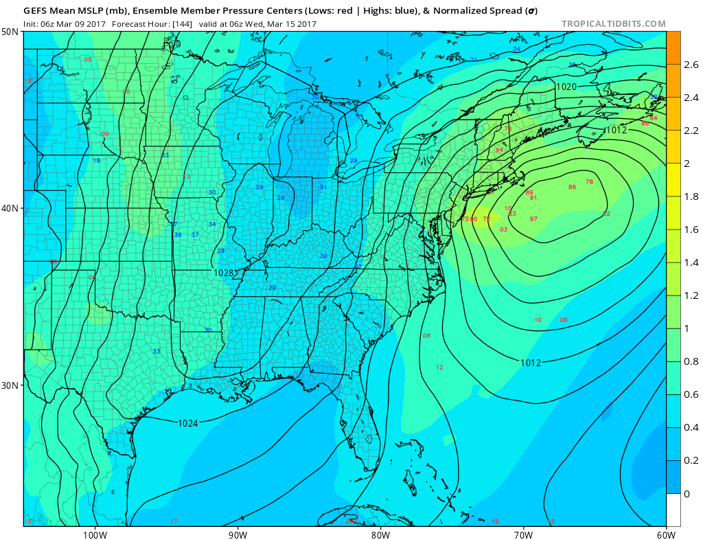
The best model right now is the GFS IMO. This solution has support from many of its ensembles and also the european ensemble members. 


Today will be a big day of runs. Stay tuned for an update around 530 tonight.

Thursday, March 9, 2017

Thursday Night Special Storm Discussion: Winter Strikes Back

Video below breaks down tomorrow morning's light to moderate snow event along with more details on potential major storm early next week. Enjoy, more tomorrow morning.


Thursday Morning Storm(s) Update: Flakes Fly Tomorrow, Big Storm Next Week Uncertain

Summary:


  • light to moderate snow moves in tomorrow morning
    • Few inches with locally more at higher elevations
    • Roads should make out ok
  • Potential big storm for early next week
    • Details still unclear as this can miss out to sea
    • A direct hit would have big impacts
    • Chance of impact 50%
  • Video tonight 8pm


Good morning. We got snow in the forecast for tomorrow morning and as usual I have made a snowfall map seen below..


Snow arrives just before daybreak and should be over before the afternoon. This shouldn't be a major issue, the higher end of the totals seen above are going to be at elevations above 700ft. Otherwise, I expect most of the accumulation to stay on the grass with some moderate road impacts in spots. This  is especially true for any areas south of I-78. I do not expect many impacts there.


Moving on, we have a potential big storm to track for early next week. As usual the details are still very uncertain and models are doing their normal wobble with this system. I am holding myself back from making any bold prediction until at least tomorrow due to the complexity of the situation. However, I think I am starting to iron out where the "miss" will be if this storm doesn't impact our area.

Lets take a look..

Many models currently show a quite significant hit for the region Tuesday...

Others like the Canadian show this storm developing too late offshore...


If we take a look at the model ensembles (normal model's inputs adjusted and rerun multiple times) we see that we have quite the spread of solutions of where the center of the storm can be...


Some members have an absolute bomb off the coast, while others are out to sea. To help with this, we also can look at historical analogs and compare what those results rendered...

You can see they support the idea of accumulating snow along the I-95 corridor which ironically splits the difference between all these different ensemble members. 

It is not that easy however, the key lies at 18000ft in the atmosphere and how interactions occur...


The biggest key, as described yesterday is the strength and positioning of the ridge out west (marked by the line). If this is sharp and positioned say over Montana, it supports low pressure development along the coast. Also, we need to look at the different pieces of energy coming together marked by the X's. The top two have been consistently trying to merge but that pesky southern piece has been dancing around. This can result in development further offshore if it shoots out too far ahead, especially with a weaker ridge. 

I will have a video later tonight around 8 to discuss this is more understandable terms. At this point I give the chance of a storm at 50% and would target areas from Harrisburg to NYC to Boston to Portland. The miss here will def be out to sea. Lets see how the trends come in over next 36 hrs. If by tomorrow afternoon this is more east I think we can bury it. 

Wednesday, March 8, 2017

Wednesday Morning: Things Just Got Interesting for Early Next Week

Summary:

  • Light snow for NNJ into S. New England Friday morning
  • Very cold air moves in for the weekend
  • Long range models showing strong signal for potential larger storm early next week


Good morning. The next 7 days have continued to become more interesting as new data comes in. Areas in NNJ into southern New England see a light snow event Friday morning, a storm misses to our south Sunday, and then a potential big ticket item is on the boards for Tuesday. For what its worth, this is winters last stand no matter what happens.

Cold air arrives tomorrow and a wave of low pressure comes along into the area Friday on its heals...


I mentioned yesterday how I thought the snow line was too far south with this and latest model data confirms my suspicion. The most recent nam model (seen above) makes the most sense to me. Areas of NNJ/PA into S. New England see 2 to 4 inches with this mostly falling Friday morning.

Very very cold air then moves in for the weekend. Temperatures will not get above 30 for many areas for highs and lows in the teens...


The cold is so strong that it suppresses a developing storm to our south seen below..


However, the suspense does not end there, all  major model groups are now indicating we can see a potential bigger storm develop for early next week. Of course they vary in exact placement and intensity, but the general idea is there. 

Here is what the GFS model is showing..


This if verified would be a major, powerful winter storm. However, this is a week away! We know that things are going to change. So given that fact, where do we go from here? Few things that concern me about this threat...


  • It is on the heals of an arctic outbreak, a signature of major storms
  • All major model groups and there ensembles look similar overall
    • many bigger storms over the years tend to give this strong signal 7 days out
  • There is evidence of persistent ridging along the west coast, a key variable of winter storms


This does not mean over a foot of snow is going to fall in your backyard. If this thing actually forms, which by no means is a lock, its a matter of the track and intensity. The only thing we know now is the signal the models and the pattern are giving. If by Friday this signal does not weaken then it will be time to get concerned. 

So lets look at the projected pattern which all the major model groups are showing to be very similar...


The key to all of this is the pattern slowing down. What I mean by that is that big ridge of high pressure seen above in the west causing energy to consolidate along the east. Think of this as a stream of water trying to move around a big bend. The water piles up as it tries to make the turn. Same happens with our weather if we see the waves of the jet stream amplify as seen above. Also, the pattern supports the cold air to stay locked in due to air coming together aloft (confluence) which triggers high pressure at the surface. 

Like I said, the strong signal is there now its just a matter of does this signal change much as we get through the next 3 or 4 days. Time will tell. Stay tuned for updates!

Tuesday, March 7, 2017

Tuesday Morning: A Close Call This Weekend

Good morning everyone. As a follow up to last nights post, we do have some storm (winter) activity to track for this upcoming weekend. As it stands now, most of this misses our region to the south. Like anything else in model land however, its not about what the models show right now but where they might trend. I have been trying to figure this out over the last few days.

Here is what my thoughts are at this current time...

On Friday, we have a weak clipper system that should impact the area. I believe any area from central NJ north has the shot at light accumulating snow. This will be nothing serious but will put a winter feel in the air. The current GFS model looks ok on this, but I would adjust the snow area about 50 miles north from what you see below valid Friday morning...


This clipper brings with it very cold air for Saturday. Temps will struggle to get into the mid 30's.

In the wake of this clipper, we then need to focus on a potential bigger system for Sunday. As stands, models are trending south with this system with a miss for most northern areas..


This is due to high pressure being too strong which acts to squash it...


 The issue here is what is causing this high pressure to be so strong. The answer is what is going on in the upper atmosphere. We have a very strong vortex over E Canada (a great sign for a winter storm, but not when it is too strong)...


If this vortex circled in red was to end up more north than modeled then we would get a storm that is allowed to come further north as well. This would have big implications for our region. 

Historical analogs suggest this does stay south but not by much...


The next 36 hours are key. If we do not see any northern adjustments by Thursday morning then we can write this off. I do think this ends up staying south as projected. Let's see what happens. We will then have one more to track for early next week.

Stay tuned. 

Monday, March 6, 2017

Monday Night Weather Tease: Late Season Surprise?

Too early to tell but there is a disturbance in the force. Cold air gets ushered in on Thursday..


In its wake a clipper system then will target the mid Atlantic Friday..


We still need to work out details on where this actually tracks. I will focus on this more tomorrow.

In the wake of a clipper a more significant system is possible for Sunday...


Models have been trending south with this and the GFS model above is only one with a direct hit to the NJ/PA area. Other models have been south such as the Canadian..


This is due to high pressure that is too strong and acts to suppress the storm.

So what will it be? Too early to tell. I will have more insight on this tomorrow morning after I look at tonight's model runs. 

Stay tuned, things could get interesting. Nothing like action at the 11th hour of winter!

Monday morning: Back from vacation

Posting resumes tonight. There is a little winter left to talk about. I will be focusing on the 10th to 17th peroid. Yes there is chancs of snow. Stay tuned, big post tonight at 7pm.