- Light snow moves in tomorrow morning
- It will be rain to start for areas around I-78 south
- A heavier band of snow develops Sat afternoon-Night
- The exact placement of this is very difficult to nail down due to nature of storm system
- The higher totals on my map are at elevations over 700ft
Good morning. I have tweaked my map from yesterday regarding tomorrow's snow event. It is extremely difficult to nail down the accumulations with this one due to the fact they will be associated with something called an inverted trough. In simple terms an inverted trough means there will be a narrorw band of heavier snowfall in a localized area. It is almost impossible to the models to nail down the exact location in situations like this.
In any event here is my map. Again, the top range of the totals are for high elevations above 700ft. It is important to remember that. This is a light event for most.
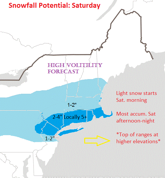
Heavier snow should develop on Saturday afternoon into the night as a coastal low takes over. This is where that inverted trough is supposed to develop to produce the heaviest band. At this time it looks like NNJ into Southeastern New England has the best chance of getting in on that band. There will be localized heavy amounts (5"+) depending on who is in the best spot.
Looking at the models, light snow moves in tomorrow morning as a warm front associated with the approaching low moves moisture into the area...

A costal low then takes over on Saturday night...

This is where the heavier snowfall should develop in my highlighted zones. You can see the next frame of this progression below...


Again, that heavier band of snow you see above (darker blue) is caused by the inverted trough. You an see an inverted trough on an upper air map by a kink in the height lines...

Where ever this sets up gets the most snow. I can guarantee you one thing with this system, some will be disappointed.
More later.
No comments:
Post a Comment