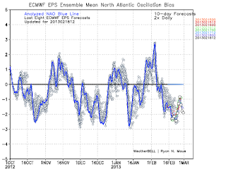
Now to the weather...its Feb 18th is winter over???? Hell no, well at least not from a pattern perspective. The weather pattern over the next 3 weeks should turn out to be a snow lovers affair for the eastern part of the country Now whether or not that happens in your backyard is always an issue. The reason I say the pattern will be active and give us shots at snow is because of the North Atlantic Oscillation Index which is going to stay in a very negative phase. The negative phase this time of year favors storms to develop over the eastern united states. Take a look...
As you can see the NAO as depicted in this graph will stay sharply negative into march. This results in an upper air patter like this...
You do not need to know how to read this map just know that the dark red region over eastern Canada is blocking high pressure. This blocking high pressure is the negative NAO and results in storms not being able to escape to the north and instead reforming on the Atlantic coast. Think of a storm system being a leaf in a river it wants to flow to the area of least resistance, the high pressure to the north is upstream so storm will reform under it. This has always given us our greatest snowstorms especially this time of year.
So after we see some rain tomorrow night (possibly some snow showers on back end) when will it snow? Right now I like the setup for a redeveloping coastal storm for Sunday the 24th. Here is the region I think that will be effected at this point...
I highlighted the area that I beleive at this point will be effected by this potential storm. The further north and west you go within this blue shade right now is the best chance at frozen precip. This potential storm threat will originate from a storm that will move into the central part of the united states as shown below valid Thursday..
Now how does a storm in the middle of the country reform on the mid Atlantic coast your ask??? The answer is the negative NAO! Check this out..
This map shows areas of high pressure in light green and orange and low pressure in blue around 14k feet in the atmosphere. The same storm system shown on the surface map is shown here, the center of it being the purple region within the blue. Notice the green and orange to the north of it as marked by the "H" I drew in. Thats the blocking high pressure which stops the storm in its tracks and forces it to move and redevelop on the coast aided by an active southern stream.
This is the setup that almost every model is showing right now. The question of course becomes where does the "L" or low pressure set up exactly. That will determine who is effected by this system and also who gets rain or snow.
We are very far out form this event, and its not until mid week that I will begin to speculate on who will exactly stand a shot at accumulating snow..however, my confidence in this happening is pretty high right now. Let's wait and see.
On a quick side note check this out...click to make each bigger

On the left was my snowfall map released for the big storm a week ago 3 days before it came, and on the right is a new map a found that shows the total tally's for the storm...not too bad right??
I have to brag on this one because I will not get them all right to this degree, so I will enjoy it while its lasts...
If the storm on the 24th does not work out we have evident of a whole lot more behind it heading into March, I find it hard to believe we will not see one more big storm on east coast....lets zone in on the 24th first...
More tomorrow


No comments:
Post a Comment