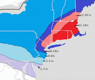
As seen, this would be no joke with amounts easily over a ft in many places with moderate winds creating possible blizzard conditions at times. I do not like to over hype things, but this does have potential to produce the snowfall shown above. I think The Boston area is locked in high probability event at this point, same with CT and Mass. NJ might be a little more tricky when it comes to the big amounts I showed because its all gonna depend on how the storm comes together at the last second but that is a good illustration for now. The amounts could be more or less for North Jersey if things change in next two days.
Here is what the European model looks like for Saturday at 1am, the height of the storm:
For those of you who are interested look at the Lindsay Storm of 1969 that ironically occurred on the same date and it is extremely similar to this potential setup. Here were the snow totals for that storm (click to make bigger):
I showed last night the 4 factors that need to come together perfectly for this storm to materialize as the European is now showing..be sure to check that post out if you want more info.
Right now it looks like snow will start close to 1 pm Friday and last until Saturday late morning, accumulating the most in the overnight hours where blizzard conditions will be very possible. I will update again tonight after today's runs of the modeling, Be sure to keep checking to get up to date data and information on this developing situation. I do not think this will be over hyped for the Boston area, its our area that we have to keep a close eye on, but for now watch out...


No comments:
Post a Comment