WINTER OUTLOOK 2023 IS NOW LIVE
Monday: Winter Knocking on Our Door
Good morning. What a week of weather we have ahead! Waking up this morning temperatures are well below freezing region wide as arctic air continues to filter into the area. A storm system approaches tomorrow that will bring rain to most and accumulating mountain snows up in New England. Arctic air then returns again for Wednesday and Thursday ahead of another storm system that can bring more frozen precipitation for many areas in the northern mid-atlantic into New England. I think its safe to say November has been very impressive so far.
Lets get to it.
A storm system approaches from the SW early tomorrow bringing with it warmer air and rain as enough cold air holds on for the Ski areas to the north to get accumulating snow. At this time I would say 6-8 inches for the higher peaks up there with a few inches possible at lower elevations...
In the wake of this system very cold arctic air returns for Wednesday and Thursday...
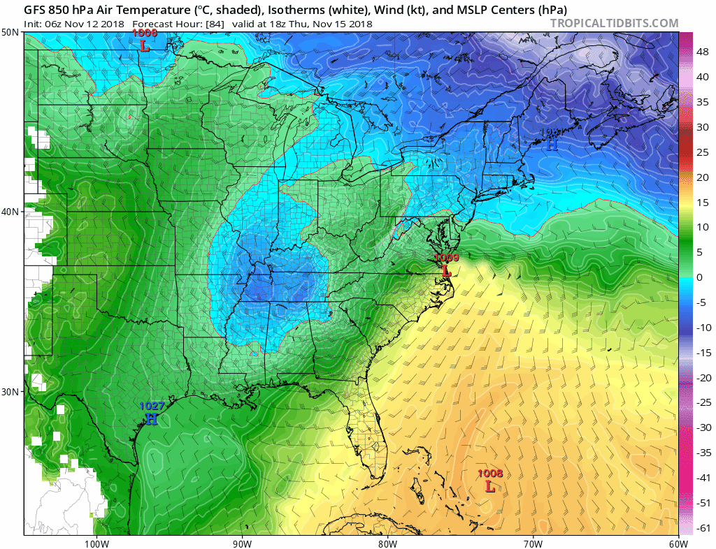
Now here is were things get interesting. A storm system then will develop to the southwest of this cold air and try to move northeast and then slide off the coast. Despite the fact the storm will eventually try to erode the cold air by approaching from the west, there should be enough cold air in place AND the slide east will allow cold air to filter back in to the area towards the end of the storm.
This means the region from western MD,PA,NW NJ into New England can see their first winter precipitation of the year on Thursday. Despite the fact things will eventually change to a mixed bag and plain rain for all areas south of New England, it will be enough for folks to realize winter may not be messing around this year.
Lets check out the evolution of the system. I am using the GFS model because it does a good enough job of giving a general idea of what can happen. Of course we do not take this as verbatim.
As cold air is in place the storm approaches as seen below trying to bring with it some warmer air (green and yellow)...
The cold air to the north will try to hang on but eventually loose out as our cold high pressure system departs to the east...
However the storms slide east off the coast means the wind direction will shift and cold air will then try to filter back into the storm. The animation below shows this nicely...
For the most part notice the cold air is most prevalent for interior PA into New England. However, there is enough in places like NW NJ and southern New England to support some winter precip with this system on the front end then again possibly on the back end.
We will have to watch this very closely this week. I will hone in on details as the days go on.
In the wake of this bitter arctic air returns again for the weekend!
Temperatures crash to feel more like December than November again with this direct discharge from the Arctic.
There then COULD be some moderation as we get into Thanksgiving.
In any event, we are off the the races on Winter 2018-2019!
More to come.


Hi everyone, Are you into trading or just wish to give it a try, please becareful on the platform you choose to invest on and the manager you choose to manage your account because that’s where failure starts from be wise. After reading so much comment i had to give trading tips a try, I have to come to the conclusion that binary options pays massively but the masses has refused to show us the right way to earn That’s why I have to give trading tips the accolades because they have been so helpful to traders . For a free masterclass strategy kindly contact maryshea03@gmail.com for a free masterclass strategy. She'll give you a free tutors on how you can earn and recover your losses in trading for free..
ReplyDelete