Summary:
- Some occasional light snow today but nothing too serious
- Steadier snow moves in tonight and will accumulate to areas to the NW especially at the higher elevations
- Snow ends south to north tomorrow morning into the early afternoon (New England)
- For areas closer to the coast expect some mixing which will cut down the accumulations
- For areas just off the coast the snow will accumulate some but warmer surface temps will keep accumulations tame
- The hardest hit areas will be in the higher elevations of NW NJ, NE PA then into NY state, CT and Mass
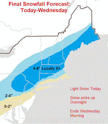
Here is the final snowfall map...
Again, its the higher elevations that will see the upper end of these ranges in my opinion. If you are closer to sea level use the lower number in your range.
Here is an animation of the storm below. Notice how the snow picks up tonight and is very light or non existent today...
I will have an update tonight around 7pm.


No comments:
Post a Comment