WINTER OUTLOOK 2023 IS NOW LIVE

The 2023 Winter Outlook

Monday, February 29, 2016

Monday Morning Weather Discussion: That's All Folks

Good morning everyone. I am now officially putting winter 2016 in the books. I no longer see any more data that would support any sustainable winter patterns for the foreseeable future. There is still a chance of a snow event this weekend, but I am leaning more towards no event at this time. 

I know many of you have felt this way for weeks now and I understand that. As I said last week, getting those thunderstorms with 65 degree temps on a mid February night was a tell tale sign.As impressive as the stratospheric warming is projected to be this month, it is a little too late. 

This winter will go down as the big one hit wonder. For New England, it is one of the worst on record in terms of low snowfall. Temps overall where also very warm. So yes guys, my winter forecast was a bust I know that. I hate to take it on the chin but it is what it is. At least we got one historical storm and we all had fun tracking it (you all know I did). I will break down and review my winter forecast later this month. 

So this week we have mild conditions with temps in the 50's and rain on Tuesday night into Wednesday morning as a front comes through..


In the wake of this front cold air moves into the area for the weekend..

This is where we do still have to keep our eye on a storm threat. Yes, some of the better weather models are not impressed with this threat but it is still on some maps. The GFS and Canadian for example still try to spin something up..

This wouldn't be anything major but still would cause flakes to fly with minor accumulations. At this time I am leaning towards more of a non event. Stay tuned in case anything changes.

In the wake of this, all signs are now pointing to a surge of warm air for next week..


The timing of this warm air pretty much seals the deal on winter. Welcome to spring!!

Thanks for reading, more this week. 


Friday, February 26, 2016

Friday Morning Weather Discussion: Keeping Tally of Upcoming Storm Threats

Good morning. Rain or snow, this pattern stays very active first 2 weeks of March. I will be traveling this weekend so posting will be limited. This morning I want to review updates to the peroid we are watching..

Starting next week, pretty confident in rain coming through the area on Wednesday. You can see this below as a cold front moves into the area.


In the wake of this front very cold air enters the area for this weekend. This is where things are starting to look interesting. Below is an upper air projection of the atmosphere for late next weekend..


What is starting to catch my eye here is the red over Greenland (high pressure) and the blue in eastern Canada (low pressure). This represents a negative NAO. Negative NAO's cause cold to stay locked in place and increase the chances for storms. Also, we have ridging of high pressure possibly near Montana. This is in a favorable position to allow energy to dive down into the east coast and consolidate due to the -NAO.  Now as always, we need to see how all these factors I just mentioned trend; especially the strength of the ridge out west and position of the blocking over Greenland.

At the surface, models are flirting with the idea of a storm from this set up..


Again, I will be out in Utah skiing that week so I bet this ends up being an epic blizzard LOL. In all seriousness though, we need to keep an eye on this next weekend. 

Following this, we then have another period we need to watch for the middle of the following week (week of the 7th)...


This is extremely far off in model land but what does have my attention is again that big area of red near Greenland, the blue near eastern Canada and finally the energy ejecting into the US through Mexico as seen in blue. Purely speculating, this could end up being sub tropical moisture being thrown into cold air along the east causing snow- especially if we get enough ridging out west.

So that is all for now. Winter might be close to the end but at least we got some active weather to track next two weeks! Rain, snow, or naught, it will keep us on our toes and give us things to discuss. The atmosphere in general is not ready for spring yet!

Thanks for reading.

PS this projection of stratospheric warming by the GFS is absolutely insane! This would really keep whole month of March a lion if verified. I will explain more next week..


Thursday, February 25, 2016

Thursday Morning: Thunder Booming now Birds Chirping

Good morning everyone. No need for the alarm clock today, the chirping birds woke me up. Is this a sign that things are over? Well no, the birds alone do not mean anything but the weather yesterday might.  I can't remember the last time I saw 65 degrees with thunderstorms at the end of February. Very depressing for a winter weather lover. 

This is pretty close to the end here guys. We got two weeks where maybe something can click and we get one more shot at a storm, but I am starting to lean in the other direction. If this was 100 years ago and we had no weather models I think common sense would rule here.

However, March is notorious for curve balls when it comes to winter weather. Let's not forget in the blizzard of 1888 it was in the 60's in NYC the day of the storm! With the projected pattern over the next 10 days something can click  and we can get lucky. If we do not well, lets just say I am not getting my hopes up for anything at this point. 

So to the pattern..

Middle to end of next week a storm should develop. Here is the upper air set up..

We have a block in place a ridge out west and energy diving into a trough in the east. However, this could also be rain if that energy consolidates too soon. I do not like seeing ridging off the east coast. Not too optimistic on this threat at this time. 

From there we go to the following week which could really be the last hurrah..

This image above valid for around March 10th might be interesting. If we see the red over Greenland and the blue near coordinates 50/50 then we might have a situation where cold air is locked in place along east coast and sub tropical moisture gets thrown into it. You can see the sub tropical energy in blue over Mexico and Texas.

Thats all for today. I just wanted to set the stage for potential storm threats we need to track- middle of next week and middle of the following week.

Thanks for reading. 


Wednesday, February 24, 2016

Quick Wednesday Note

Good morning. Lets wait for this rainstorm to fully exit the area today then I will focus on what will be the home stretch of winter 1st two weeks of March. It is no secret this winter has been a one hit wonder for areas of Mid-Atlantic and one of the worst for New England (no snow). With that being said, the atmosphere is still projected to be ripe through March 15th for things to develops along the east. Could this mean more rain? Sure, but it also could go the other way as well. If we end up pulling off one more decent storm then at least the snowfall numbers for the Mid-Atlantic would come in decent. There is no saving New England and there is no saving my 1-2 degree departure from normal temperature projections. 

I had a good run with the last two winters forecasts I put out (2014 and 2015). You can find old copies of those on tabs of this blog. This year I did swing and miss for the most part. Well, maybe I hit a foul ball because we got a top 4 storm in last 100 years!!! Regardless, if we do pull off one more big one it wouldn't be a total failure of a forecast. In any event, 2 out of 3 isn't too bad.

I would say that since I will be traveling to Utah to ski next week the chances of a big storm are very high! LOL seriously though it will be active that week.

Stay tuned for more details tomorrow on home stretch. 

Monday, February 22, 2016

Monday Morning Weather Discussion: Rainstorm On Tap This Week, Return to Cold This Weekend

Good morning everyone. We had a beautiful weekend and now its time to focus our attention to the unsettled weather this week. I have discussed extensively the details behind this weeks storm and hopefully by now you all know why it will be rain. In any event, lets summarize what to expect:


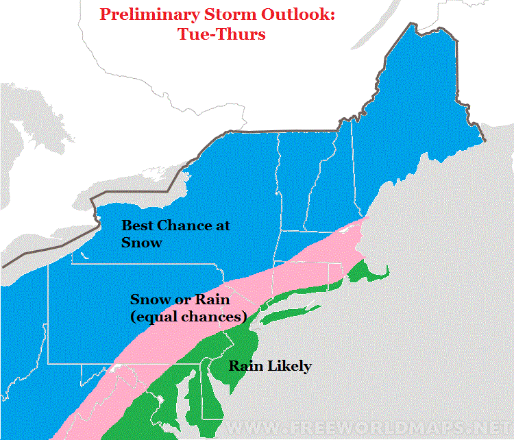
  • An initial wave of rain enters the area tomorrow afternoon
    • There is a chance that some snow can mix in in northern counties Tuesday night
    • I do not expect any high impacts from this
  • The main storm moves into the area Wednesday and lasts through Thursday morning
    • expect heavy rain and wind all the way up into New England
    • How depressing
  • In the wake of this storm cold air moves back into the region for this weekend
  • Although we are close to spring, there are very strong signals pointing to an active 1st half of march
    • These signals include stratospheric warming, which will cause the polar vortex to weaken and funnel cold air into the east.
    • Along with this, all models indicate a persistent ridge of high pressure out west which will also enhance colder than normal conditions
  • We are not out of the woods till after March 16th in my opinion.
So lets take a look at the graphics behind my bullet points..

An initial wave moves through Tuesday night..

There will be some cold air ahead of this as a high pressure system departs the area but I do not expect any high impacts. Just do not be surprised if some flakes are flying. 

The main storm then hits Wednesday into Thursday morning with all that rain..


As I discussed this week the ridge out west being to far west caused this storm to track inland..

I will admit I did not expect a full blown cutter but oh well.

In the wake of this storm cold air moves in for the weekend...


Expect high temps in the 30's. Moving into March, all signs point to a pattern like this..


This keeps things active. Notice the big trough of low pressure south of the Aleutian Islands, the massive ridge out west and the trough in the east. Also, we have high pressure over Greenland which is a negative NAO. This is not a spring pattern!

Yes, I know its easy to just say winters over and it was nothing more than a one hit wonder. However, we can not ignore these strong signals for March. This means can not be surprised if a big storm forms sometime in the first two weeks. 

Like I mentioned in my summary, the stratospheric warming is a huge driver of this..

Notice the polar vortex trying to split near Greenland. This should prevent any full blown surge of spring. 

We will keep track of all this over the next few weeks. Lets just get through this miserable rainstorm first. Sometimes mother nature just does what it wants regardless of what the weather patterns look like. Will that be the case for this home stretch of winter? Time will tell.

Thanks for reading. 

Sunday, February 21, 2016

Sunday Morning Weather Update: Might Squeeze Out Few Flakes, But Main Event Rain

Good morning everyone. Well, I can confidently tell you all we have a big rainstorm on tap for this week. This includes even interior New England which I thought had a shot here. I never liked the idea of snow in big cites or even the I-95 but I did not expect the storm to track this far inland. Maybe I should have listed to my own words this week when I kept discussing how those trends in the ridge positioning where a bad sign. Oh well, here is the updated forecast:


  • Some rain moves in tonight
    • High elevations of extreme NW NJ might see a few flakes
  • An initial wave of low pressure enters area on Tuesday night
    • Some cold air will be in place so there is a shot of northern counties into southern New England actually seeing some accumulating snow!
    • Stay tuned for more details on this
  • After this initial wave moves through, the main storm develops and cuts to our west Wednesday
    • This means warm air surges in and we get rain all the way up into interior New England
    • Rain should end Thursday
  • Colder conditions return in the wake of this storm.
  • Believe it or not, the first half of March stays active with colder than normal conditions and shots at snow
    • I know everyone wants to call winter over, but we can not let our guard down
    • Factors like stratospheric warming will keep things interesting as cold stayed pooled near the east
I cut a short video below breaking down this week including the shot at some snow Tuesday..


Saturday, February 20, 2016

Quick Note

Todays models continue the trend of more wet than white. For most of my viewers expect a rain storm. If you have been following me all week, that ridge position I discussed did us in. Interior New England this is not over YET but trends are not good.

I will have an updated forecast out in the morning.

Saturday Morning Weather Discussion: Trying to Lock Down this Storm

Good morning everyone. A storm forming next week is now imminent. However, as I have been discussing over the last several days the track remains to be seen. Today I will go into my preliminary thoughts on what I think can happen. This will be my first attempt at forecasting this. Fair warning, this is likely to change as this storm is extremely volitile. I broke down the reasons why in my video last night.

Here is a summay of my thoughts:


  • Major storm effects the eastern 1/3 next week
  • Big questions remain over where this storm will track
    • Some models have it tracking well inland giving the whole region a rain storm
    • Other models have a colder and snowier solution for NW of I-95 into New England
  • THIS IS NOT A BIG CITY SNOWSTORM
    • Why? Simply because we do not have the factors in place ahead of this system to hold in cold air and dictate a track far enough off the coast
  • For areas north and west of interstate 95 I would say you have equal chances right now at rain vs snow
    • This is not the ideal set up but there are scenarios where folks in these areas can see snow next week
  • Interior New England, I really like the chances for snow

Here is a map summarizing my preliminary thoughts..


The video below gives my updated take on how this will evolve. I tried to keep it no longer than 3 min.


Friday, February 19, 2016

Friday Night Storm Discussion: Model Mayhem

Video below gives my updated thoughts on next week's storm. Wait till you see how complicated this really is!  Regardless, I will try to start forecasting this over the weekend. 

Next update tomorrow mid morning. 


Friday Morning Storm Update: Trends In The Wrong Direction

Good morning everyone. Well, I have discussed the key factors I am looking at for this storm next week and the impact they would have on its track. In particular, I have focused on the position of the idge axis. They key was to see where do the models trend this ridge axis. More to the west near Oregon and we have a warmer inland scenario. More to the east near MT and we have a big winter storm. Over the last 48 hours the trends have been in the wrong direction. Things will still change but at this time things do not look good for high impact winter storm for anyone near a big city next week. It is not easy for me to say that considering I love snow, but I need to tell you what I see.

Here is the bottom line:


  • Big storm impacts the area next week
  • Recent trends in models have moved towards a warmer storm closer to the coast
  • This is due to a ridge axis out west that is not in the right spot.
  • If this verifies it means rain for areas in the Mid-Atlantic and snow for interior New England
  • This is far from a lock, it is a very complicated set up and things will still change over next few days.
  • There is also the chance for a surprise snow event Sunday night into Monday morning for northern counties
    • models are split on this idea 
    • I will cover this tonight if there is more agreement on this 
  • I will have a preliminary forecast out this weekend for Wednesdays storm
So basically when I look for factors that would drive a big winter storm in the east I want to see:

  1. Ridge axis near Montana
  2. Blocking ridge over Greenland
  3. High pressure locked in place by a 50/50 low
  4. A trough that goes negative near the coast
Based on the trends in the latest European Ensemble we have NONE of the above..

I really hope I am wrong here but the data does not lie. This has inland runner written all over it. In fact, look at the massive sift in the European ensemble ridge position over last 48 hours..


Old run from 48 hrs ago on left new on right. If that is not a clear trend then I do not know what else is. Notice the where the low is on both images. 

At the surface it would look something like this..


What a crushing blow for snow lovers that would be. Look guys maybe I am being too pessimistic here considering we got 5 days to go and a very complicated set up. I know this is going to change. My point in today's post is that the trends have been in the wrong direction. If you want snow, you need new trends to now develop back the other way next 24 to 48 hours. I will start to release my actual forecast ideas this weekend with impact maps etc. 

As far as Sunday night this would be the best case scenario for snow below in northern counties. Not all models agree on this yet..


Thanks for reading. I will have an update tonight. 

Thursday, February 18, 2016

Thursday Night Special Video Discussion: Where Will Next Week's Storm Track?

Thursday Morning Storm Update: Warmer Trends Emerge, Will They Hold?

Good morning. As the title says, recent trends in model ensembles have been towards a warmer solution for next week. This means the chances are decreasing for a snow event along the coastal plain and even some areas NW of I-95. I discussed yesterday how the position of the ridge of high pressure to the west is critical for this storm. This directly influences where the storm forms and how close to the coast it tracks. Pump up a ridge too close to the west coast and you have a storm that track too close to the east coast. Pump up a ridge near Montana and you put a storm in a perfect spot for snow. Along with this, you need an area of high pressure to our north funneling in cold air for a big snowstorm. Models have not been too impressive in this regard either. Here is the latest bottom line:


  • Big storm is becoming likely for next week
  • Recent model trends have been warmer with this system
  • The is due to the projection of the ridge axis of high pressure out west trending closer to the west coast
  • This results in a projected storm track closer to the coast
  • A storm track closer to the coast means warm air can filter into the coastal plain
  • In addition, models are not too impressive with showing a strong high pressure system to our north.
    • This is needed to supply cold air, especially if a storm develops too close to the coast
  • THINGS WILL STILL CHANGE WE ARE 6 DAYS AWAY! I AM SIMPLY POINTING OUT LATEST MODEL TRENDS
  • As of now I am sticking with the idea of rain for big cities, a chance of snow for NW of I-95 with the sweet spot of this storm being up in interior New England
So lets take a look at the trend in the key factors. I am going to use the European ensemble to keep things simple. In the below image, the old European ensemble runs are on the left and new on the right.


Notice the key factors on this image. On the left images (old run) the ridge axis is more to the east near Montana. This causes the low to be more off the coast thus a colder solution. Also, notice the high pressure trying to hold on. 

On the right images (new run), notice that ridge axis now more towards the west coast. This causes a warmer storm closer to the coast. That high pressure is also more to the east. 

So that is all I have for now. We are still so far off that this will inevitably change more. However, lie I said I am really not expecting big cities to see snow. My big question mark is can the areas NW of I-95 (NW NJ,NE PA) see winter impacts from this. At this time I am not ready to make that call. Snow lovers in those areas there still is hope but this is gong to be tough. For ski areas, this looks like it could be your storm.

Lets see how this evolves. I will start to get more detailed on my prediction by this weekend. Still speculation for now. 

Wednesday, February 17, 2016

Wednesday Morning Storm Outlook: Storm Idea Gaining Traction, Track Questions Remain

Good morning everyone. The models and their ensembles continue to indicate a storm to develop in the eastern 1/3 towards the middle of next week. As always, it isn't always as difficult to predict if storms will form as much as the actual track of these storms. The track determines who is in the warm and cold sector of a developing storm. At this time I am focusing on NW of I-95 of having a chance at winter impacts with this system. The risk here is that this trends more inland.

 There are certain features that help drive a storm track including:


  • Position of the ridge axis out west
  • Timing of disturbances interacting
  • Upstream blocking near Greenland
In this case, I want to focus on the difference in the ridge axis in the different model ensembles. Where the center of the ridge pumps up will determine how close to the coast this storm comes. Ideally we want the ridge axis over MT. Looking below you can see the European ensemble on the left and GFS ensemble on the right...


Notice the euro ensemble has a low slightly more off the coast compared to the GFS (top images). This is due to that ridge axis being more to the east on the Euro. You can see this below by the black line I drew in. It might be hard to see but that slight difference has a big impact on track.

Also notice the euro has a stronger area of high pressure to the north of the low. This means colder air would be allowed to funnel into the storm creating more of a snow threat closer to the coast. Regardless, we do not have ideal conditions near Greenland with blocking high pressure. This means the track is all the more important to who gets snow.

Here is the bottom line at this time:

  • Chances are increasing for a storm to develop next week
  • The overall setup does not really support snow for the big cities due to ridge positioning and lack of blocking upstream
    • This can change considering we are 7 days away.
  • Further inland, the best chance at snow at this time would be NW  of I-95
  • There is potential for this to shift even more west causing rain for those areas too
  • The sweet spot looks to be interior New England if I had to speculate

Again, this is still pure speculation. I am gaining confidence in storm development but I can not really give any predictions on regional impacts for at least another couple of days. 

Thanks for reading. 

Tuesday, February 16, 2016

Tuesday Morning Weather Discussion: Brief Warm up Followed by Big Storm Threat Next Week

Good morning everyone. Yesterday pretty much tuned out as expected. Most areas saw 1 to 3 inches of snow with a coating of ice. We now we await the rain that will move in later today. '

Two things I want to focus on today:


  • The brief warm up we will see over next few days
  • The continuation of this active weather pattern through early March including a big storm threat for middle of next week
    • The overall pattern to support a storm has high agreement among major model groups
    • I will be covering the trends in this extensively over the next week. 

First off, lets cover the boring part. The weather will moderate over the next few days as a ridge of high pressure builds over our area. This is nothing more than the overall pattern reloading for what I believe will be a cold and storm period end of Feb into early March.


However, so not fast. As we enter early next week things get very amplified again along the east. We will have a deep trough of low pressure develop south of the Aleutian Islands of Alaska. This will cause a ridge of high pressure to pump along the west coast which causes a deep through of low pressure to develop in the east. We are 8 days away, but signals from all the major model ensembles are very strong with the overall set up...


Above is the European weather ensemble. I marked out the important features. Please disregard my misspell of Aleutian lol. When we are trying to assess the threat of large storms we need to see certain features have high agreement among models. The three most important factors are: The deep trough south of the Aleutians which supports a big western ridge (centered over MT is key, supports eastern trough more towards the coast), which in turn supports an eastern ridge. In addition I am seeing strong signals of air coming together or confluence over eastern Canada. This is also key because it supports high pressure to stay locked in place over our area. Notice we do not have a big blocking high over Greenland. However, with a piece of the polar vortex there instead, it seems to be pressing down enough to cause that confluence to develop. This almost acts like a negative NAO. 

You can see all three major model ensemble groups generally agreeing on this set up..


Not going to lie, seeing this agreement really has my attention for big ticket potential next week. 

What a setup like this would cause is a storm developing around the Gulf of Mexico and tracking right up the coast around Wednesday or Thursday as you can see below.


So as you guys can see this winter is not over! A big part of this is not only the El Nino weakening but the stratospheric warming. We already had one episode of warming and now the models are showing enough blow to the stratosphere in the long range. This would really increase our chances for March coming in like a lion..

More later.

Monday, February 15, 2016

5pm Update: Cold Air Holding Firm at Surface, Ice an Issue Tonight

Our storm is underway and most areas see 1 to 3 inches before a changeover to ice. The biggest development today is the cold air holding on a little longer than modeled at the surface. You see this happen a lot with departing arctic air masses- the models underestimate them. This means through 1am tonight anything that falls will freeze in northern counties especially NW of I-95.

Video has no sound had mic on mute like an idiot. But you can at least see the projected radar on the video. Will update late tonight.


Monday Morning Storm Update: Snow Spreads In Later Today

Good morning everyone. Those of you who are lucky enough to have today off hope you have a relaxing day. Lets dive into our storm.

Here is my forecast from yesterday. I have edited it with my final thoughts. 


  • Snow works its way into the area later this afternoon
  • All areas should see snow to start
  • This means today sees winter storm conditions in all areas
  • Snow will change to ice in green zone late tonight
    • Icing will be an issue initially
    • I tried to add a black line to show where I think the ice can be the biggest issue for those folks in the Green Zone late tonight
  • By the time we get to daybreak Tuesday it is raining in the Green zone
  • In the pink zone, Ice holds on longer until an eventual change to rain by late morning
  • The Blue zone gets the most snow and Ice and it should stay in colder sector of the storm

I need to mention that no one is out of the woods until tomorrow morning. We currently have bitter cold air in the region..

Models always tend to underestimate how much of a fight cold air masses like this can put up at the surface. This means ice will be a big issue in areas in the northwest zones of this image. More info in video below..


Stay tuned for updates later this afternoon when flakes start flying!

Sunday, February 14, 2016

Sunday Afternoon Storm Update: More Wet Than White Tuesday

Good afternoon everyone. Looks like we now have more clarity on our storm system for tomorrow night through Tuesday. Here is the latest:


  • Snow spreads into most areas Monday night
  • The snow then quickly changes to ice then rain for most
  • In the green zone expect some accumulations before changeover to rain
  • In the pink zone the surface should stay frozen longer causing more of an icing concern Tuesday morning
    • I expect this whole area to eventually change to rain as well Tuesday 
  • The blue zone represents the snow zone. 
    • We should see 6-12" inches of accumulation with some mixing possible 
  • In the wake of this storm we see a very brief warm up followed by more bitter air and storm threats
  • I see no signs of a spring pattern until at least 2nd or 3rd week of March
    • Whether or not we see a big storm will remain to be seen!
So basically as you can see things have trended warmer over last 24 hours. At this point I do not think they will change back. As impressive as this current arctic air mass is, it will in fact move out of the area completely as this storm approaches. Since the storm will develop inland, that mean it bring in a surge of warm air from the south. This why I expect any snow and ice to change to rain for most areas.

The NAM model sums this up well..

Monday night..snow spreads into area due to enough cold air in place


Early Tuesday morning...warm air quickly flows into the region as arctic air mass departs causing a change to ice..

Late Tuesday morning..the powerful southerly flow causes most areas to change  to plain rain..


Moving  to the upper atmosphere you can see how the southern shortwave of energy we have been looking at over the last few days will in fact be stronger not weaker. This means it allows the southerly flow and more inland storm track. The way this storm would have been colder and more off the coast would have been if this southern feature was weaker. That was not the trend..


At the end of the day the European model wins the coupe this time. It and the UKMET British model have been most consistent all week showing the warmer solution. 

I will have an update tomorrow morning with a play by play. Stay tuned!

Updated Forecast Out by Early Afternoon

Saturday, February 13, 2016

Saturday Morning Storm Update: Model Spread Continues, Sticking With Preliminary Forecast

Good morning everyone. Although we are starting to get a little more clarity on the situation for Monday night into Tuesday a lot of uncertainty remains. I am sticking with my preliminary forecast below..


  • The dark blue zone should expect a significant snowstorm.
  •  The pink zone will feature a front end thump of snow Monday night, changing to ice,  then eventually some rain
    • I am concerned that the ice will be a big issue for this area Tuesday morning
  • The green zone will start as snow but quickly change to ice then rain
    • There will still be impacts early Tuesday morning. 


I will update this tomorrow. At this time we have two ends of the spectrum. The European model is still the warmest and farthest west with this storm..


The Canadian and GFS models remain further east. I will add that we have had some very good consistency in the Canadian model last few days. Below you can see what it is projecting. Notice the snow changing to ice and remaining ice just to the NW of I-95. This is a big concern of mine. 


The GFS is not far off from this. As I showed yesterday, the differences in the models more west vs east is how strong they are modeling the lead shortwave ahead of this storm. The GFS and Canadian are stronger with lead shortwave and weaker with the southern shortwave. The result is a colder storm. Here is an updated image showing this below..


European is left Canadian is right. Might be hard to see but on the Canadian the lead feature (top circle) is stronger. This holds cold air in a little longer and causes the storm to develop more to the south and east. 

So we have a lot t track here guys and I am sure more things will change. I do feel really good about what I have out right now however. Stay tuned for more details to come!


Friday, February 12, 2016

Friday Morning Storm Outlook: Releasing My Preliminary Impact Map for Tuesday

Good morning everyone. As we have been discussing, we are tracking a storm that will impact the area Monday night into Tuesday. So many details need to be worked out as usual (as they all say), but I want to try my best to keep you guys ahead of the situation and give you my best thinking. First lets take a updated look at model projections for Sunday mornings temps!


Yes that's sub zero in many spots! Highs all weekend will only be in the teens for many areas. This is the result of the polar vortex coming to town..


Ok back to early next week.

 Here is my first projection on what can happen Tuesday..


We do not currently have the proper set up for a big east coast storm (big cities). This is due to the bitter cold air we will experience this weekend (sub zero in spots) exiting the area ahead of this storm. HOWEVER, in this pink zone the cold air should put up a fight. I expect things to start off as snow Monday night (few inches possible) then transition to ice then finally rain. There is a big risk here cold air can hold on near the surface  especially in the western areas of the pink zone. This means freezing rain and a potential horrible commute Tuesday morning. Rain should eventually take over but not until some impacts are made. 

For the green zone, things should start frozen but I expect a much quicker transition to rain and limited impacts at this time.

The jackpot looks to be the dark blue zone where significant snow accumulations are possible. I will note there is some model guidance that is west of my map which would result in even the dark blue zone getting liquid. At this time, I am trying to show you guys what I think will happen as opposed to just copying a model projection. 

This map will be updated twice over the next 4 days. I will eventually have a snowfall map then tweak it to a final forecast as event approaches.

So now that you have a general idea of what I am thinking, lets take a look at the maps. We have a wide range of solutions here as the models are still struggling to get a handle on this. The image below is my best way of showing whats influencing this storm. The European model is on the left and the Canadian on the right (click to make bigger)..


Looking above a few things to note. Notice how the European model has that southern feature stronger. Also compare it to the Canadian which has a weaker southern feature and more evidence of a stronger lead short wave ahead of this storm. Here lies our forecasting issue folks. The key to the track of this storm depends on what feature ends up being modeled correctly. If the lead short wave as seen on the right image ends up being stronger like the Canadian shows then it will help hold in the cold air longer and also develop a low closer to the coast. If this does not happen as the European shows, we have a warmer solution. This is what we are going to have to track over the next few days.

My forecast map is basically a blend of these two with some input from the GFS model. I also am trying to look at similar storms from history. At the surface here are some model projections for Tuesday morning..

GFS..


Canadian..


As you can see much different outcomes and it all comes down to the features I discussed above!

More later.