WINTER OUTLOOK 2023 IS NOW LIVE

The 2023 Winter Outlook

Sunday, December 1, 2019

Sunday 7pm Update: Need to Up Totals, Roads No Good Tomorrow Afternoon

Good evening,  We have some changes I needed to make to the forecast due to modeling becoming more consistent in developing a very heavy band of snow across most of the forecast area by Monday afternoon. Do not be fooled if things look fine in the morning with temperatures above freezing and clean roads. This storm will start to get going by mid morning and really get nasty by early afternoon. This means roads will be a disaster by tomorrow afternoon. I have big concerns about this. 

Again timing is mid morning tomorrow into early Tuesday morning with the peak tomorrow afternoon into the evening. For Eastern New England the storm will wind up by tomorrow night. Heavy snow tonight across interior New England. 

I will have a very early morning update around 630 am in case there are any last min changes. 

Here is my brief video update below which also includes my updated snowfall forecast:


Stay Tuned for Big 7pm Update

Surprises are on the horizon with this storm.

Sunday Morning Storm Update: Made Some Tweaks

Good morning. We have our first signifigant winter storm on the season knocking on our doorstep this morning. In fact, I think areas north of I-78 see a quick burst of snow later this morning. An inch or two can pile up before the changeover. The real storm then starts Monday.

My usual 7pm Update will be live tonight.

I updated my forecast to try to account for where Monday's snow band may set up. As I discussed this is extremely hard to pin point...


Updated Timeline:


  • Front end burst of snow this morning for areas from I-78 north. An inch or two can pile up before a change over to ice and rain (south)
  • There will then be a changeover to rain and ice and stay all snow over interior New England
  • Then expect a lull in the storm tonight before part two takes over Monday morning
    • This is where an impressive band of heavy snow can develop over the region
    • Timing is Monday morning into early Tuesday
For the Green Zone: mostly rain some flakes at the end Monday

For the Light Blue Zone: Ice storm in PA with a quick burst of snow this morning changing to rain by this afternoon. Snow then will fall again Monday. I do not think you get into heavy band at this time but that can change.

For the 4-8" Zone: Burst of snow this morning accumulates 1-2 inches then changes to a sleet storm. Rain can also work in for areas closer to coast. Snow then returns Monday morning accumulating several inches

For the 6-12" Zone (over  NW NJ and  NE PA): This is where I am trying to pinpoint that band of heavy snow Monday. Temps will not go above freezing today and by tomorrow morning you can see potential heavy snowfall rates through the evening. This is highly hard to predict and has potential to bust.

For the 10-16" Zone: All Snow


So our storm system is currently cranking to our west. Overrunning precipitation is currently approaching the forecast area...


Temps currently are dry and cold. This means when the precipitaiton arrives in a few hours snow should break out for areas north of I-78...


I am thinking that this causes 1-2 inches of snow to fall to the nw of I-287. 

Things then change to sleet and rain...


We then get a lull in the storm tonight (still snowing over New England) and the real action potentially starts tomorrow morning as a low redevelops off the NJ coast. 

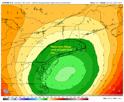
This is where an impressive almost impossible to predict band of snow develops on the back edge of this storm...


This is from Monday morning to Tuesday afternoon. I am intersted to see how tonights model runs look when it comes to handling this snow band.

If our upper level low is strong and deep enough, then this will happen. If it shifts north then NJ is taken completely out of the snow. 


Stay tuned, more to come tonight. This is still evolving.

Saturday, November 30, 2019

Sat Night Video: This Will Come Down to The Wire

The video below discusses my updated thoughts and evolution of tomorrow's storm system.  Models are hinting at a very unpredictable back end band of impressive snow Monday.

The main impacts for the NYC metro are Monday all day. No changes to my snowfall map. Next update will be tomorrow morning.


Saturday Morning Storm Update: Tricky Forecast

Good morning. Here is my updated forecast for Sunday through Monday.  Usual 7pm Video update tonight as this storm evolves. 


Summary:


  • Winter storm on track to impact the region with a mix of rain, ice, and heavy snow
  • For Purple Zone:
    • A heavy long duration snowfall event is to be expected with over a foot of snow in many spots
  • For the Dark Blue Zone:
    • Sleet and freezing rain moves in by mid morning Sunday for areas in NW NJ, NE PA, CT
    • The ice changes to snow by late Sunday night/Early Monday morning
    • Several inches of snow can pile up Monday morning
  • For Light Blue Zone:
    • Some sleet to start Sunday morning but a transition to rain
    • Rain changes to snow on Monday morning giving this region a quick few inches
  • For Green Zone:
    • All rain maybe a few flakes by Monday afternoon, coating in some spots possible

So this continues to be a challenging forecast for the fringe areas of this storm (dark blue). I discussed in my video last night how NNJ and NE PA are in the wildcard zone for this storm. This is because we still need to see how this backend snow band evolves.


Latest models do indicate we see this band get just into NE PA and NNJ by Monday Morning. Below is the latest European model from Sunday morning to Monday night...


Notice the pivot of the storm at the end to throw that band back into the area. This is the detail that will still be moving around on models. IF this stays more north then snowfall amounts are cut down significantly across NJ and PA. If we get a shift south, then we get more heavy snow over NNJ. It will all come down to the placement of the upper level low....

If this feature at 18000 ft ends up being a little tighter and further south, the snowfall will shift south. If it  ends up more north the snow shifts more north. Models will be wobbling around with this feature through tomorrow. That makes pinpointing snowfall within 50 miles extremely difficult

I said it yesterday and I will say it again, this storm will be surprising us through tomorrow morning with updated model projections moving these features around.

Stay tuned for evening update. 


Friday, November 29, 2019

7pm Storm Update

Friday: Significant Winter Storm to Impact Region Sun & Monday

Good morning. A signifigant winter storm will impact the Northeast Sunday and Monday.

My map below is my updated forecast. I will also have a video out tonight around 7pm.


Summary:


  • A low pressure system approaches the area from the west on late Sunday morning, early afternoon
    • Areas across interior PA and NW NJ will see all snow and ice as temperatures should not go above freezing for the duration of this event
    • Areas to the southeast of I-287 expect mostly rain to start Sunday afternoon
  • The low pressure system then redevelops into a powerful storm off the NJ coast on Sunday night into Monday
    • expect heavy snow to break out across most of New England and NNJ by the time we get towards Monday morning
      • This is where several inches of snow can pile up in those darker blue zones
    • Rain should still hold on for areas south of I-78
  • By Mid to late morning Monday rain should change to back end snow for most areas south of I-78
    • A few accumulations are possible in these areas by Monday evening
  • Storm then starts to pull away by Monday night
  • I have concerns of this storm making last min shifts to the northeast
    • this would mean NNJ doesn't see as much heavy snow

So as you can see this is a very complex and tricky storm system. The reason is we do no fully know exactly where this low pressure center will redevelop off the NJ coast. IF it develops more north than modeled then only New England sees the heavy snow. If it develops just south of Long Island then NNJ gets in on the heavy snow Sunday night.


The model European model below (from Sunday morning to Monday night) gives a general idea on how this may evolve. My concern is the European is a little too far south with the heavy snow and this can end up adjusting more north. This means NNJ is still in the wildcard position for this storm...


First off, this is a very signifigant storm system. Notice that back end band of heavy snow being showed towards the end of the loop. My concern stems on if this shifts more northeast compared to whats shown. If that happens then its mostly all of southern New England that sees the heavy snow. I have been burned before on storms like this making last min shifts. 

Notice even areas down to Phili can see snow at the tail end of this causing some accumulations. 


I am going to cut a video tonight around 6 or 7pm to discuss the evolution of the major winter storm.

Stay tuned.