Good morning everyone. As you are aware by now I am/was tracking the potential for a coastal storm this weekend. From the weekend I told everyone that this is pure speculation until we saw the "players" come on the field. Well today is Wednesday and those players (upper air disturbances) are getting close to the field and I do not see the overall trend I am looking for. The towel is in my hand but I will wait till tonight until I throw it in.
To start off, it looks like we can see some light snow on the arctic front Friday morning This is better than nothing and most models are trying to show this below..
Expect 1 possibly 2 inches of accumulation as this will be a very high ratio snow because of the arctic air. *It will be very cold tomorrow through the weekend.*
Then the main target period approaches and right now I only have one model (the European and its ensembles) trying to support my storm idea for Saturday, although it even still has some work to do.
Most models continue keep the 2nd and larger storm threat out to sea..
The European and its ensembles are more impressed and bring this closer to the coast..
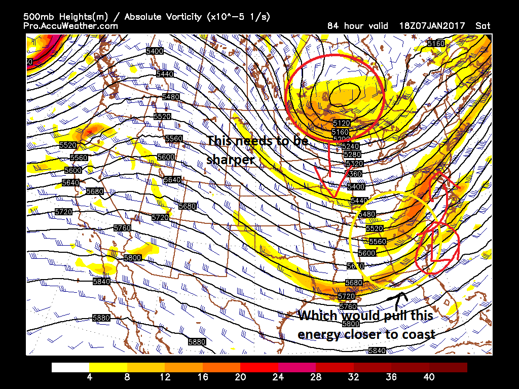
Why the difference? Well like I have talked about it all comes down to the upper air energy guiding the storm at the surface..
The below image taken from the GFS explains it again..
You can see how the approaching disturbance in the northern jet stream must be very sharp and dive into the lakes hard. If that happened then the 2nd disturbance associated with the southern jet stream would respond and hug the coast closer. Right now, the gfs is not sharp enough with the northern disturbance and it allows the 2nd disturbance to round the bend wide right resulting in an offshore storm at the surface.
It would not take much to change this but regardless I do not like the lack of trending on the major models. A few European ensemble members have a big storm but that is not nearly enough to make a case. It is for this reason that the towel is in my hand and I will likely throw it in by tonight or tomorrow morning once I get a little more data.
Stay tuned.
WINTER OUTLOOK 2023 IS NOW LIVE
Wednesday, January 4, 2017
Tuesday, January 3, 2017
Tuesday Morning: Waiting and Seeing
Good morning. There is not really to much I can add from yesterday's post. The period to watch is this weekend as a small disturbance might effect the region Friday with a larger storm threat on its heals. At this time, there is no real support from models to make any bold predictions. Most guidance takes the storm systems south our our area as the upper level energy does not amplify properly. The key will be to wait till about Wednesday to see if any of this changes. Thus, we are just speculating at this time.
You can see how models are south over the weekend..
This is due to the flow too flat and unorganized. If you want a stronger storm that at least has a chance of moving more north, you need to change a few things..
For one, the southern piece of energy circled needs to be sharper and less flat. That northern piece also has to dive in sharp enough to help turn a developing storm north. Right now no models show that. The only reason I am not calling this threat off is the fact that these "players" are not on the field yet meaning the energy is not property sampled by the models (it is way off the country). By the time we get to Wednesday, I should be able to say if this has any merit as those disturbances will be in better sampling range for the models.
So we will see what happens. I always want to show you guys what can happen as opposed to what the models just project will happen. That makes things more interesting.
More to come.
You can see how models are south over the weekend..
For one, the southern piece of energy circled needs to be sharper and less flat. That northern piece also has to dive in sharp enough to help turn a developing storm north. Right now no models show that. The only reason I am not calling this threat off is the fact that these "players" are not on the field yet meaning the energy is not property sampled by the models (it is way off the country). By the time we get to Wednesday, I should be able to say if this has any merit as those disturbances will be in better sampling range for the models.
So we will see what happens. I always want to show you guys what can happen as opposed to what the models just project will happen. That makes things more interesting.
More to come.
Monday, January 2, 2017
Monday Morning Weather Discussion: Still Eyeing Late This Week
Happy New Year everyone! Will the first week of 2017 feature snow? Still too soon to know for sure, but as I discussed in my last video I am watching the evolution of the weather pattern at the end of this week for a chance.
Here is a summary:
Here is a summary:
- Peroids of cold rain today and tomorrow with temperatures in the low 40's
- Weather clears out by Wednesday with cooler conditions
- Very cold air moves in for Thursday into the weekend with highs in the 20's for many areas and lows in the teens
- We then have to watch for potential winter storm development over the weekend
- This is still speculation as many factors need to come together
- Over the next few days we should start to get more clarity on if this becomes a real threat
- No sustained warm ups on the horizon, winter is here
Rain today and tomorrow as low pressure moves through the area. The track of this low allows some warm air to filter in..
We see clearing on Wednesday as very cold air approaches from the northwest towards the end of the week..
This is ingredient # 1 for storm development- cold air in place.
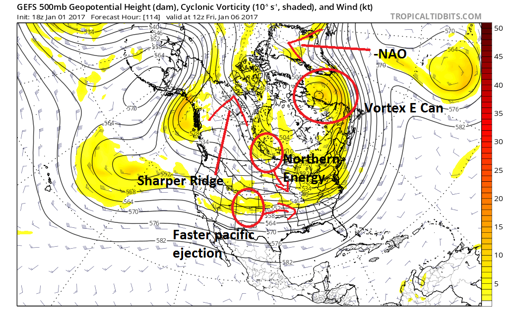
We then have a few pieces of energy to track which would need to come together properly for storm development. These pieces are labeled below..
A storm developing will depend on if that northern energy can dive sharp enough into that pacific energy ejecting from the west. If these two pieces come together perfectly then we can see a big storm. However, if that northern energy comes in too flat or that pacific energy ejects slower then we have nothing. The models right now are wobbling all over the place on how all these ingredients come together. These rapid swings should continue for the next 48 hours at least.
The one thing that has been more consistent in this set up is the -NAO (high pressure over Greenland) and a vortex of low pressure in eastern Canada as seen labled above. This is a major factor in helping that cold air stay locked in ahead of the storm and this alone makes it worth discussing this threat.
So lets get to surface projections. Right now most models show a storm developing offshore due to a flatter interaction between the northern and southern energy..
There have been a few model runs however that have blown up a storm due to the factors being in sync. The next image shows the GFS model from last night valid for Saturday night..
You can see the aggressive output here with a major winter storm. I show this as an example of what can happen of all the factors come together property. There is absolutely potential on the table here.
So where do we go from here? It will be critical to study model trends over the next 48 hours and see what direction they go. If by say Wednesday we still see the hint that the bigger storm can develop then you will start to see me take things more seriously and start to forecast. At this time however all we can do is just sit back and watch. There is simply just too much margin for error in the models this far out to make a prediction.
More to come.
Saturday, December 31, 2016
New Years Eve Discussion: Winter Storm Late Week?
Happy New Years Eve! The short video below breaks down the weather over the next week including a first look at the potential for a winter storm late in the week. As always details are still very unclear and this can go either way at this point.
Friday, December 30, 2016
Wednesday, December 28, 2016
Wednesday Morning: Major Snowfall for Parts of New England Tomorrow into Friday
Good morning. Latest data has not backed off on a major snowstorm for part of interior New England. This is a ski country delight.
Here is a summary:
Here is a summary:
- Low pressure system develops tomorrow morning along frontal boundary
- Initially this causes snow to fly tomorrow morning in central-north PA, NW NJ (higher elevations) and parts of CT
- As the storm deepens rapidly off the coast tomorrow afternoon/night NH and ME get the brunt of this system with accumulations likely over a foot
- Areas near the coast in New England are a mix/rain but can see snow on the back end as this explosively deepens tomorrow night
- Storm is over by Friday morning
- The overall weather pattern gets very cold and active as we enter January
- Stay tuned for more info on this
Here is my snowfall map..
And my short video breaking this impressive storm system down..
Tuesday, December 27, 2016
Major New England Snowstorm Possible: Details Still Emerging
6pm update: No video tonight, my thoughts have not changed much. Tomorrow AM will have snow map out with video included. This is not a mid-Atlantic storm it will hit ME, NH and parts of VT and Mass. I am interested to see if there are any eastern trends that develop tonight that would limit snowfall.
<<<<<<<<<<<<<<<<
Good morning everyone. I am off this week from work so I have a little more time to focus on the weather. I mentioned on Saturday that we had to keep an eye out of storm development late this week for New England. Latest model data continues to come in and it indicates this storm can in fact form and become a real threat.
Here is a summary:
- A low pressure area is expected to form along an approaching front on Thursday
- This low pressure system is projected by some models to rapidly intensify as it tracks just off the cost of Long Island into the Gulf of Maine
- Depending on the actual intensity of this low, it is likely that heavy snow will break out for areas in New England
- This includes most of MA, VT, NH, ME and some of CT
- Heavy accumulations possible
- Further to the south snow can fall in NE PA, NW NJ and SE CT
- Accumulations can range from light to moderate in these areas
- The time frame for this projected storm is Thursday afternoon into Friday.
- This has the POTENTIAL to be a major coastal storm for New England
There remains a spread in the models but this is my first map breaking the situation down..
Right now this is a very difficult forecast. The short range North American model and the European model insist this storm blows up off the coast while the flagship American Model (GFS) is not as impressed with the coastal development. What else is new?
My forecast comes from my interpretation of all the data along with historical comparisions. That leads me to belive that this storm will be a compromise between the aggressive short range American model (NAM) and the GFS. The map above is a weighted blend of each.
So lets take a look at what is going on. Looking at the most agressive scenerio first, the NAM model rapidly intensifies a storm due to amplified short wave energy at 18000ft..
Looking above we have the more amped up solution on the left (NAM model) and less impressive situation on left (GFS). Just know that the more sharp the trough is the stronger the storm is.
Here is the surface projections..
NAM model..
GFS..
I will have a video out breaking this down along with updated model data tonight at 5pm.
Subscribe to:
Posts (Atom)