WINTER OUTLOOK 2023 IS NOW LIVE

The 2023 Winter Outlook

Monday, January 19, 2015

Monday Morning: Closer Look at Wednesday's Clipper and Early Next Week nd

Few quick points this morning.

For one we need to see how this clipper evolves. Right now I am leaning towards light snow Wednesday into Wednesday night with maybe small accumulations The models have been pretty inconsistent with this clipper and based on the pattern ahead of the storm I do not think things will be ripe enough for a big redevelopment.

Here is the GFS from last night..


And the NAM model hot off the press..


Both models are not impressed with this clipper and I am going to agree with them. The flow in the jet stream is too progressive or in other words flat. This is a different look that what was projected a few days back. So snow showers might be the word here. I do not see it worth making a map.

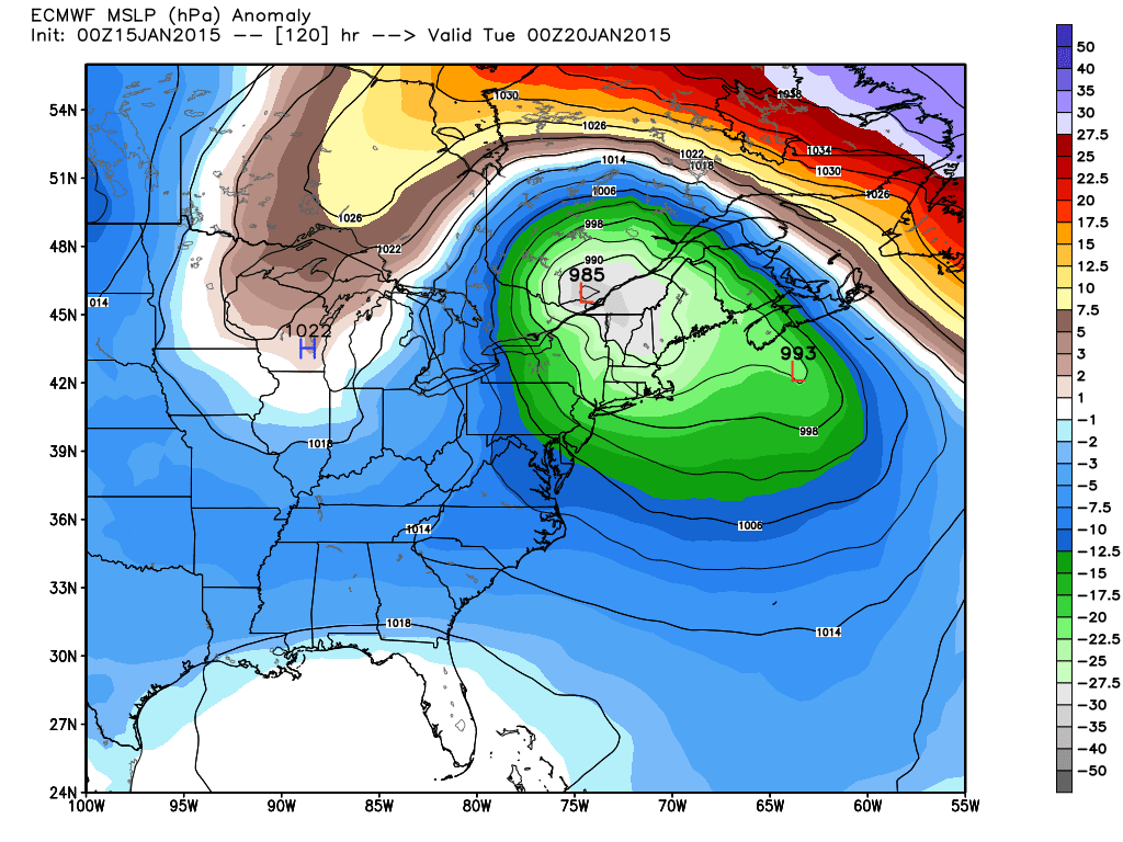
Moving on we have a large trough in the jet stream expected to develop by the end of this weekend..

This is very interesting for early next week because of the potential size of this trough and the energy that can get bundled into it. When I see the amplitude of a trough like this you need to be on the lookout for a big storm. Notice there is not high pressure over Greenland in this scenario. That means that if a big storm forms it can just as much cut into the lakes as it can move up the coast. It is all going to come down to timing of when the northern branch does or will phase with the southern branch to dictate the track of this potential storm. I am only bringing this up because I am impressed with the consistency of the models in showing this outcome.It is something to watch over the next few days.

More tonight, I have a day off so more time to post. 


Sunday, January 18, 2015

Sunday Afternoon Video: Weatherwilly Loosing Hope

Video below discusses my current thoughts on the weather pattern for the next week. I talk about the clipper snow potential Wednesday and the fact how every time things look like they might turn the corner into a snowy pattern it completely reverses back to cold and dry. 

Enjoy the rant, I tried to stay constructive. At this point we just gotta hope for one decent snow event before March 15th. It can't get any worse. For snow haters, congratulations your winning at the half 50-0.


Friday, January 16, 2015

Friday Morning: Now We Sit and Wait to See if this Pattern Delivers

Good morning everyone.This morning I want to give an updated look on snow threats over the next 10 days. Everyone already knows by now that I really like the pattern that is developing from my previous posts so lets summarize things to watch in the upcoming period. 

Starting off with late this weekend into Monday. Interesting spread in the models here as the European is the outlier with the most westward track compared to the GFS and Canadian. I am not 100% throwing out the Euro however due to the face the British model which I deem pretty accurate is almost exactly the same with its placement of the low pressure system. In any event, I think this is what to expect.

There is a chance this can bust and the storm does not effect anyone in those regions but I can not say that with two models looking so consistent. 

Here is the example of the Euro and British model side by side with placement of the low.


We will know by tomorrow AM if this will verify. If these two models shift east then the GFS wins this battle. I'll be in Northern VT skiing so this would be money in the bank for me. 

Moving on, we need to watch Tuesday night into Wednesday for a moderate snow threat that is more favorable for all areas as a low pressure system can develop just to  the south of NJ and move just off the coast.


With a lot of cold air in place ahead of this system, there would be a good chance at snow  if things pan out.  Once again the British model looks similar to the European model above but the GFS or American model is not too impressed with this system either. Time will tell.

Finally as we head towards the end of the 10 day peroid next weekend we need to watch for a potential big ticket item. 

Below is a rough drawing of what the European ensemble mean is showing ahead of this threat..

Because of the fact I see a potential -NAO and 50/50 low signature I am mentioning this threat this far out. But in any event we need to wait and see what happens as it is too far to get too excited over at this point. If anyone is looking for a big storm this would be the potential setup for one. 

So there you go, at least we got some potential action on the table. Now we wait and see if any of this verifies starting with the late weekend snow threat for interior New England. I will have limited access to the blog but will try to update via my cell as I am skiing this weekend. Let's hope there is good news to report.

Thanks for checking in. 


Thursday, January 15, 2015

Thursday Night Note

No big post tonight, I am saving more detail for tomorrow morning. But this upcoming weather pattern really does have potential to deliver. Whether or not it does is out of our control, but in any event it will make for some interesting reading on this blog next few weeks. I am looking forward to tracking all of this. 

Thursday Morning: Are We Awaking the Sleeping Giant (Winter)

Good morning. For the first time this winter season I can say I really am getting excited over the weather pattern that is developing. We started discussing a few days back how important a negative NAO was to getting the shot for snowstorms along the east coast. Models were starting to hint back then that the NAO could occur but it was too early to make a call. As I sit here and look at the models today I can confidently say a developing NAO is now likely! 

Let me stop there. This does not mean a storm is guaranteed! All it means is that unlike before the soil, if I may use a farming analogy here, is much richer meaning we have a more favorable environment for storms to form. This pattern is so essential because it locks in the cold air and blocks storms from cutting into the lakes or out to sea in many cases. 

Here is the European ensembles prediction of the upper air pressure pattern for days 5-9.

You can see that -NAO signature developing over Greenland. We want to now watch to make sure the reds set up more to the west of Greenland. The further west the better for winter storms. If we get the reds to set up too far east of Greenland then storms can cut inland. Regardless, this projection is the most encouragement I have seen all year and matches all the research I did when I made my winter forecast. Too bad its halfway through January already so we have a lot of lost ground to make up.

So now that we have a favorable and may I add colder weather pattern setting up for the rest of the month we can start to take storms threats more seriously.

It looks likely at this point that a storm will effect interior new england on Sunday night into Monday. I mentioned this yesterday. Here are latest model projections..

GFS

Storm develops late near the gulf of Maine and would give central and eastern Maine, and VT/NH mountain snows. 

The European is much more agressive and actually is warmer due to it phaseing the storm earlier..

Very strong storm, but a warmer solution than the GFS. In this case extreme interior New England gets the snows. 

I think right now you blend the two models and what your left with is a coastal storm that gives interior mountain snows. This is not a coastal snow threat at this time due to cold air leaving ahead of the storm. You can see below how warm air advances in on Saturday night due to a low pressure system north of Michigan dragging in a warm front..The non grey colors show warm air advancing.


Too bad that one factor is throwing this whole situation off. Regardless, I will be in Jay Peak VT skiing this weekend and im hoping I get lucky with this situation. This can change but right now I do not see a big snow threat for areas near the coast.

Moving on, looking at the very long range we have another threat to monitor for next weekend..


I am only showing this because I like the pattern. Obviously it is very far off and in no way is this a prediction. Just something to watch for now. 


Wednesday, January 14, 2015

Wednesday Morning Weather Discussion: No Big Warmup Coming, Interior New England Could See Snow

Good morning all you weather fans. As we continue to progress through this relativly snowless winter the same broken record repeats. When will it snow? Well I discussed over last few days how we do need a critical component which is that high pressure area over Greenland as it locks in the cold air and prevents storms from cutting inland. Over the last few days the model trends have continued with their signal of that developing over the next 10 days.

Here is the updated European..

Notice the reds near Greenland. That would be a developing -NAO and this is valid for next week. So we got some encouragement there. At least we see a trend developing here. In fact, I mentioned the models have backed up on a big warm-up. Here are temperature departures from normal in the 5-10 day peroid..


Now the 10-15


No blowtorch as some expected. So now we keep waiting as more days a weeks of our winter season pass. 

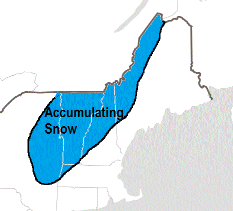
So lets discuss a potential snow threat for interior New England for Sunday night into Monday..


What we have above is a storm developing along a front on Sunday night. The set-up actually looks like it could be ideal ahead of this storm for all regions but the problem is an initial area low low pressure north of Michigan on Saturday and Sunday brings a warm front into our area, thus destroying the cold air. The red line I drew below shows this.

This prevents cold air from staying in place which is a red flag for anyone outside of interior new England for potential snow.

Aside from this one factor, many other parts would have been there..

Instead, as that shortwave or kink in the jet stream as seen above swings through and some sub tropical energy try's to phase with it at the last second near new England along the front. We will keep watching this, but as of now Folks in central and western Maine, VT and NH are in the snow potential zone.

The waiting continues...hang in there snow lovers.  

Tuesday, January 13, 2015

Nothing to add Today, The Importance of the NAO

Seasonable conditions through the rest of the week. We then see a warm up but its only going to last through half of next week. I am at a point where I am just going to wait and see how things play out. It has been a very disappointing winter for a snow lover like me . I can not emphasize enough how getting that negative NAO is so critical if anyone who reads this blog wants a big snowstorm. The diagram I put up yesterday is a simple explanation why. Think of it as slowing traffic down on a highway. The negative NAO buckles the jet stream so disturbances approaching from the north in Canada and the south from the sub tropics have a better chance at coming together. It also locks in the cold air for snow to fall if storms do form.

This is a table I found that shows the biggest snows for some mid-Atlantic cities and the state of the NAO. Notice how most are negative. Note that this table only goes to 2010.


So we now wait and see. In terms of my winter forecast I think the temperature part might do ok but mother nature better get to work quick on the snowfall predictions or that part will be a big bust.

Models are hinting it could go negative but as I said yesterday we need to just wait and see. Here is the GFS ensemble box and whisker plot on the negative NAO representing the spread in outcomes for each day. The black line is just the control run so you can disregard that. 


The first number on the x axis represents the day of the month. Disregard the second number.