WINTER OUTLOOK 2023 IS NOW LIVE

The 2023 Winter Outlook

Monday, October 28, 2013

Siberian Snow Cover a Big Factor In Winter Predictions

I briefly mentioned in a post last week that there has been extensive research at MIT by a individual named Judah Cohan that suggests the amount of snow cover over Siberia in the fall months especially October is usually a precursor to the temperatures of the United States during winter. The main reason being that the increased snow cover strengthens the Siberian High pressure which results in high level warming over the stratosphere which ultimately breaks up the polar vortex (coldest weather in the Northern Hemisphere) and displaces it further to the south near the US. 

Looking at current snow conditions over Siberia we are running above normal. In fact September snow cover was 9th most recorded on record for Eurasia. Here is a graphic showing current snow cover..
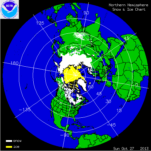

As you can see most of Siberia is covered in snow which is a good sign if you want cold air for winter. To take it a step further Cohan developed a model to project what the winter temps would look like based on Snow Cover, here was last years forecast..


Here were actual temps for last year..


Pretty impressive accuracy and the main component as i mentioned is snow cover. 

With all of this being said there is a factor that needs to be mentioned that can counteract this above average snow cover and it is a pattern called the quasi-biennial oscillation (QBO). In simple forms this is a weather pattern that represents easterly and westerly zonal winds over the extreme altitudes of the equator.  When the westerly's propagate downward from the stratosphere it tends to favor less high pressure over Greenland and the Arctic. When this is in its opposite easterly phase more blocking is favored.

Right now we are in a westerly QBO which does not favor blocking to the north which is essential for an active winter. Here is what westerly QBO years have looked like..This graphic shows the correlation. Blue and purple colors are a negative correlation meaning a west QBO results in low pressure not high pressure over the Arctic. 


As you can see a west or positive phase QBO results in a negative pressure correlation to the north (low pressure) and a positive correlation to the south (high pressure, warm conditions.) However, with above normal snow cover, low solar activity, very weak warming in the El Nino region and model projections for this winter, which all favor blocking, there are a lot of moving parts to look at. Before I release my final winter forecast (coming within a week) I want to figure out which of these factors have been most dominate over the last few decades.  

Friday, October 25, 2013

Northern Hemisphere Snow Cover Highest in over 30 Years...A Precursor to a Cold US Winter


Notice difference from 2007 between snow in Siberia. Here is a graphical chart green is the average..


Oh and by the way for the global warming crowd take a look at the purple region and how much the northern hemisphere ice has increased. 

Wednesday, October 23, 2013

November 2013 Temperature Forecast


Above is my expected temps for November. I think the jet stream will be weaker than it currently is with more of a flat flow through most of the month. Most of the action weather wise will be in the Pacific Northwest and possibly a storm or two developing for the mid-section of the country.

I do not expect any big weather events for the East Coast thorough at least mid-month where the jet stream may become more amplified. We are going to be entering a positive AO/NAO which is not favorable for colder than normal weather over our area for this time period. A lot of forecasters are calling for a slow start to winter and a mild December, but I have a hunch the winter might start off with more action than that for first two weeks of December that then things should settle down until Jan. 

This current cold pattern should last another 5 days before the more seasonable weather arrives. Keep your eye on the lake regions as some higher elevation towns can get several inches of snow over next few days. 

Monday, October 21, 2013

Latest High Resolution Model Temps

As a addition to my post below check out recent temp projections from high resolution model for highs Wednesday and lows Wednesday night..


Low's


Cold air stays locked in next 5 days at least from Wednesday. 

Sunday, October 20, 2013

Sunday Night Pattern Overview: Cold Air Very Close

The pattern change I have been discussing is underway and will be noticeable for our area by Wednesday with much colder conditions in the 50's. That is 5-8 degrees below normal for this time of year. The local weather outlets have already begun to hype it. This pattern change is due to a few large scale features including a big ridge out over the west coast, and blocking over the top in Greenland. These features are seen below...notice the large green area which represents the polar vortex displaced over Northeastern Canada..


This setup allows cold air from Canada to flow into the eastern third of the country. Combine this with an active southern jet and we have a setup that can cause a northern stream disturbance to tap into some gulf moisture by middle of the week. 


This setup will cause a cold rain for our area and some light snows inland of a few inches possible especially over higher elevations. In addition the low pressure system spinning over Canada will cause some lake effect snows this week. 

So how about the rest of the month into November...

Long range guidance keeps a trough over the east around Halloween..


This will keep temps on the colder side for this time of year through month end. I suspect this pattern will break by November where some seasonal conditions will come back into play. Until then we will see very active weather associated with that trough with the potential for multiple chances at snow over the lakes region and possibly interior Northeast.

My winter forecast still looks good based on recent data. I will be updating that sometime in Nov. I think the low sun activity will be a big factor based on recent research.

Stay tuned for updates on mid-week system which could becoming interesting.

Pattern Update Tonight..A More Detailed Look at Next 15 Days

Wednesday, October 16, 2013

Next Week's Temperature Departures From Normal


All departures are in C. Expect up to 5 degrees below normal for our area in F. Bringing temps into the mid 50's. Pattern change will be noticeable by next week and should continue through the end of the month. Many chances for precipitation through this period, I will provide more detail later this week.