WINTER OUTLOOK 2023 IS NOW LIVE

The 2023 Winter Outlook

Sunday, December 2, 2012

Sunday 10pm: Pattern for Mid December Now Solidifying- Cold and Snow Very Possible

I wanted to wait a few days since my last detailed post to see if the trend kept materializing and it has. The middle of this month starting around December 11th lasting through Christmas will get very cold across the entire US. In addition all the factors are in place for things to get very active as well in terms of the potential for a storm or two. So lets take a look at what those factors look like on December 12th..

source:weatherbell.com

Notice all the red across Greenland (Negative NAO) the north pole (negative AO) and in the Gulf of Alaska region (negative EPO). All three of those triggers in there negative phase result in a very cold pattern for the US as seen above with the green and blue region spreading across the entire US. When it comes to cold stormy patterns in the US especially the east coast, it doesn't get much better as what this model (European) is showing. Now the question becomes will a storm develop within this time frame. Right now the european model has a storm out in its long range projection as seen below..

source:accuweather.com

Now going out this far on models anything can change and in most cases they can just give an idea of what COULD happen. Not every model is as aggressive with cranking a storm like the European but historically the European is the most accurate weather model out there. 

So what is my take given this robust output from the European and also the GFS (didn't show graphic but looks similar to European)?. Even tho not every model out there is converging on this cold stormy solution, I am predicting that what is show above will happen. I cannot at this point say at what date a storm will form- it could be around the 12th like the european model shows or it could occur later in the month, but in any regard I would be surprised not to see  a winter system form during this time frame- giving us a white Christmas. I see too much evidence supporting this prediction and not as much to the contrary. 

In summary, while the next few days will be warm, a winter pattern will return starting around December 11th and last through the end of the month. All the players are on the field from a meteorological standpoint, and whether we see snow fall on December 12th as shown above or sometime later in the period, I believe snow will fall and be on the ground for Christmas. Keep checking in, I will be posting updates.

Saturday, December 1, 2012

Details Coming Tomorrow On Upcoming Pattern

In short, things will be very exciting from mid December on as I have been saying for a while now. The chances of a white Christmas are increasing every day. I will go into more detail tomorrow with some graphics.

Friday, November 30, 2012

Friday 12 PM:Not Many Changes From Prior Post

Looking at latest guidance, things look on track as I originally discussed a few days ago. Middle to the end of December looks very cold and active and there is still a chance a storm can develop between Dec 6-10 time frame, but at this point I am making no predictions. Once I have a chance to review more modeling this weekend I will update this blog.

Wednesday, November 28, 2012

Looking Calm Till Mid Dec. Where Things Can Get Wild, Maybe a Surprise Along the Way

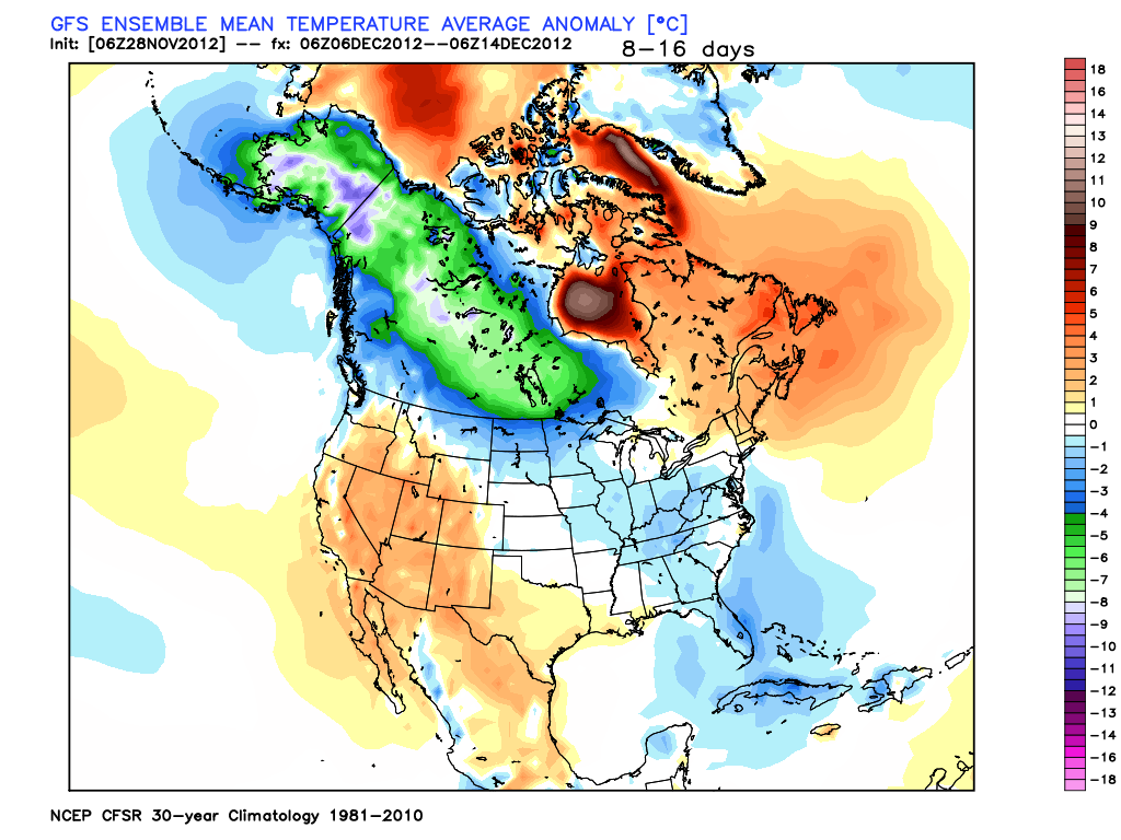
Good Afternoon. I have been evaluating the weather pattern and also some of the wide scale climate signals I look at such as the trend in the NAO, AO, PNA (see basic lingo defined page for explanation) along with some long term modeling that shows potential temperatures and precipitation for the month of December.  What I can say is from mid December on watch out, things look like they will become very active giving us increased chances of a white Christmas. The best way to show this is graphically so here are some of the outputs I have been evaluating.

source:weatherbell.com

Above you can see what the GFS model is predicting for temperatures in the Mid December time period. Notice along with the below normal temps shown on the east coast, there is also an enormous amount of cold air building up in central and western Canada. This is called the source region and once the jet stream buckles it allows all of this cold air to flow into the USA similar to a dam breaking. Usually when I see this along with some other signals I will show you in a second It tells me cold air is on its way. Now lets take a look at the NAO index.

source:weatherbell.com

The blue line is what the observed value of the index was (already occurred)  and the black line shows the forecast for this pattern. The NAO is very low right now, will rebound entering the beginning of December then crash again heading into mid month. This gives the East Coast a good shot at a favorable Storm setup mid month. Many times north east storms occur when this pattern is in its transition phase meaning when it is on the move from negative to positive. You can see from the 1st of December to the 6th of December it is making this transition. Which gives us the potential to see a storm develop around the December 6th time period. Here is what the upper atmosphere will look like at that time.
source:weatherbell.com

Notice the trough over the east coast with the ridge in the west (blue vs orange). Now modeling does not have a storm at this time just has a strong front coming through, but I wanted to show how there is a chance but I am making no perdition at this time.

Finally, lets put all of this together and have a little fun and look at what the long term climate model is showing for snow cover for the middle to end of December. This is far to overdone, but It is exciting to see none the less and shows that the idea of a white Christmas is on the table. Check this out, each box represents the same model but run with a few different variables changed as you can see much of country is covered in snow. Again this is overdone, but can provide a clue...
source:weatherbell.com


In summary, things will warm up and quite down over the next week. All eyes are on mid Month where we will have a favorable atmospheric setup for cold and stormy conditions giving us a chance at a White Christmas. If there will be any action before this period it will occur around the 6th of Dec. Stay Tuned.


Tuesday, November 27, 2012

Snowfall Totals


Below is the link to the recorded totals around the state of NJ. As seen, totals range from 2-4 inches and locally 5.

Click For Snow Totals

Accumulating Snow Will Wind Down Soon

Looks like we received the 2-4 locally 5 inch amounts I have discussed over the last two days, and hit the lower end of my original 3-6 inch forecast. The snow will start to wind down over next few hours from west to east tapering off to light snow then flurry's. Keep checking in for new posts on upcoming December pattern.

source:accuweather.com

2-4 Inches Today

Snow will start soon and last until this evening, accumulating the most between late morning and late afternoon. Total accumulations will be 2-4 inches with locally 5 in areas of higher elevation. My original forecast was for 3-6 inches four days ago, so we will hit that range but on the lower end. Enjoy the snow