WINTER OUTLOOK 2023 IS NOW LIVE

The 2023 Winter Outlook

Tuesday, June 12, 2018

Tuesday Weekly Weather Summary: Calm and Pleasant

Good morning. Not much to say for this week. Temperatures have been on the tame side all spring/early summer and that will continue next several days.

The only chance for some showers at this time is Wednesday afternoon as a weak front moves into the area...


High pressure then returns to the region for the weekend...

This means pleasant temperatures in the high 70s to low 80s with very little humidity.

Some heat will try to build by early next week as a ridge moves into the area...

However, as the theme has been going all season this does not look to last and cooler air returns for the end of next week and beyond. You can see this by a ridge of HP over the west and trough of low pressure/cooler air in the east...

Considering I hate hot and humid weather I am not complaining.  So far I have not used my AC all summer. Lets see how long the streak continues.

Monday, June 4, 2018

Monday Weekly Weather Summary: Cooler But Ok Overall

Good morning. As we now have entered June, many have been wondering where is summer? The last several weeks have featured a lot of unsettled weather along with frequent rain. As we head into this week, it will be a little more of the same but not as wet.

The highlight of this week will be the cooler than normal temperatures. Temperatures will be in the 70's and maybe even high 60's on Wednesday. This is due to cold Canadian air flowing into the region.

Today will clear up nicely with temperatures in the 70's.

Tuesday also looks to be a decent day with partly cloudy skies and a chance a an isolated shower or storm later in the day..

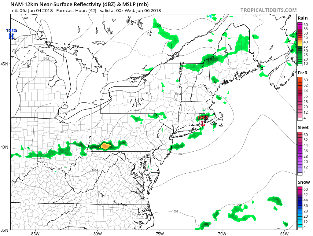
As we enter Wednesday, a cool Canadian high pressure system moves in which will clear up the skies but cause temperatures to drop below normal..

This is where many areas, especially up in New England will see highs in the 60's.

The rest of the week then stays tame with temperatures climbing slightly but still staying in the 70's with mostly sunny skies.

For the weekend, we need to watch out for showers and storms as a warm front will try to move up into the area. The question then becomes will a low pressure system try to form along this front causing rain issues for Sunday.

Right now the models are showing something can happen later on Sunday...

Before that however, it does look like the weekend can be spared with maybe just the chance at some afternoon showers and storms Saturday afternoon.

Overall not a bad week just cooler than normal. As the next few weeks progress, it looks like a continuation of this cooler than normal and unsettled pattern continues. As we enter late June and July, a normal summer pattern should take hold which should eliminate the chances of any rainstorms. Instead, we will see the normal pattern of afternoon showers and storms at times. Regardless, I do not see any big heatwaves on the horizon.


Thursday, May 24, 2018

Memorial Day Weekend Forecast: Mixed Bag

Good morning. As promised, I wanted to give everyone a holiday weekend forecast. Overall, it looks to be a mixed bag this weekend. Things start off very summer like tomorrow through Saturday with sunny skies and temperatures in the 80's with some humidity building Saturday. By Sunday however, unsettled weather enters the region causing showers. The weekend then may make a comeback just in time for Memorial Day.

The pleasant stretch of weather for Friday and Saturday comes thanks to some high pressure entering the region...

Friday will truly be the best day with sunny skies and low humidity.

By Saturday, we see mostly clear skies but the humidity increases as we get into the afternoon. With this increase in humidity there is the chance we see a few isolated showers, but nothing to be too concerned about. Temperatures will warm to the upper 80's.

Entering Sunday, things will start to go downhill as moisture from the south runs into a backdoor frontal boundary coming from the northeast...

Expect mostly cloudy skies with showers in the morning then again in the afternoon on and off. You can see this illustrated above.

By the time we get to Monday, there is hope some nicer weather can return. Expect mostly cloudy skies in the morning with the chance the sun breaks out by the afternoon. Temperatures will hover in the mid 70s with the chance at a few showers.

Thats all for now. Lets hope we see more sunshine than rain!

Monday, May 21, 2018

Monday, May 14, 2018

Monday Weekly Weather Summary: Unsettled and Wet

Good morning. After a beautiful week last week this week will feature the opposite. Rounds of showers will effect the area all week and by the weekend we will see the shot at a more consistent rain as tropical moisture moves in.

There is currently a frontal boundary hovering over our area. As the week progresses disturbances will move along the boundary causing showers and storms...


Some sun could break out for a little bit tomorrow, but unsettled conditions will follow.

This pattern continues all week and we then have the tropical moisture enter the mix...

You can see below a tropical system that will be in the Gulf producing alot of rain in that area...


By Thursday this all working it's way up near us...


This will cause quite the rainy scenerio Friday through the weekend.

I will have an update later this week.

Monday, May 7, 2018

Monday Weekly Weather Summary: Pleasant

Good morning. After the rainfall yesterday, we not will embark on a very pleasant stretch of weather. In meteorological terms that means boring, but for most normal folks it is quite the good news.

Expect mostly sunny conditions this week with temperatures in the 70's. The only wrinkle in the equation I see right now are some potential showers Thursday night as a front moves through..


This front will keep temperatures nice for the weekend which also looks to be quite nice at this time. We could see some more showers Sunday but the jury is still out on that.

The next actionable weather item will be severe weather season. As summer like temps and humidity eventually arrive so does that threat. This blog will get more active if anything catches my eye in that regard. Until then, expect weekly weather summaries on Monday's and a weekend update on Fridays.

Enjoy the week. 

Friday, May 4, 2018

Weekend Update: Saturday is a Winner

Good morning. We finally got our dose of summer temps this week. Temperatures rose into the 90s but with low humidity this was quite nice in my opinion. 

For today, things stay on the warm side with temps in the mid to upper 80s.

A cold front then moves in tonight and a few isolated thunderstorms are possible...


The front will bring a cool down for Saturday with sunny skies and beautiful temperatures in the 70s!


As we enter Sunday, a disturbance from the south can cause scattered showers as the day gets underway...


This means mostly cloudy with some breaks of sun possible as afternoon wears on.

Enjoy the weekend!