Good morning everyone. This post will focus on my target period of the 16th though the 24th. In particular we will look at the weekend of the 19th. I have talked about the overall set up in the weather pattern over my last several posts. In summary, I am not expecting a full pattern change until we get to January (based on observations and my winter forecast) but I mentioned how there are signs we can see a period of action before then. Mainly this could be in the Midwest into Interior New England. A big reason why was the projected set up of the jet stream for that period...
The map above shows the overall idea for the target period. We have high pressure forming over Gulf of Alaska. That presses cold air into the country. We also have some blocking develop just south of Greenland. This also helps trap the jet underneath, especially the cold air that the Alaskan high pressure system is seeding. The idea is that there is a chance we can get this energy consolidated enough that a storm can form on the cold and warm air boundary by the weekend of the 19th.
It is still mostly speculation due to the fact we are 7+ days away but it is still worth mentioning in my opinion. The GFS has been the model consistent model showing something trying to develop at the surface for that weekend..
This would be the overall idea of what could happen- a storm that develops along that boundary and effects interior areas with snow. Pretty much a ski country special. But we need to start seeing a lot more support from other models and their ensembles.
The European does not have a storm due to the energy I talked about staying too spread out...
This map above shows the Europeans upper air projection. notice how spread out the blue is and we can try to identify a few different centers of energy.
Compared to the GFS below which is more compact.
Thats really what it comes down to guys. The models as with any potential storm threat will need a few more days to sort it out. Remember however if this does end up developing I am expecting it to be more focused on the interior not the big cities or say even 80 miles to the west.
I will keep an eye on this as we head through this weekend.
On another quick note the stratosphere is still showing signs it comes under stress in the longer range..
This is the main factor I am looking at to support my pattern change idea for Jan as it would weaken the polar vortex and give us the chance for more sustained shots at cold air.
This is my original January forecast from my winter outlook..
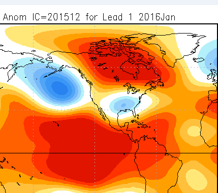
Latest NMME blended model guidance for January (came out yesterday)..
Lets see how this unfolds!
Thanks for reading.
WINTER OUTLOOK 2023 IS NOW LIVE
Friday, December 11, 2015
Wednesday, December 9, 2015
Will Old Man Winter Wake Up? Breaking Down the Upcoming Pattern
In this video I break down the weather pattern from the 16th through Christmas. We are a little too far off to make any bold statements BUT I like the trends I am seeing. Bottom line: I think areas of the Midwest up into New England need to be on the lookout for a storm system to bring potential snow, especially around the 19th (next weekend). Further to the south is a wild card. Things should really start to get interesting after the next 7 days. I will drill down more as the days go on. Let's see if any of my speculation becomes a reality.
Buckle up folks, many signals are starting to flash for a pattern change, especially as we get into January if not late December.
Wednesday Morning Weather Update: Some Encouraging Signs Developing
Good morning everyone. As I continue to monitor this weather pattern I am starting to see signs up hope for winter weather lovers. Although I still do not expect a big pattern change till end of this month/early January there are some encouraging signals I am watching develop.
Going back to the stratosphere (way up in the atmosphere, higher than commercial jets), models continue to suggest the polar vortex will come under stress as heating is starting to occur...
Looking above you can see what the atmosphere looking like at the 10-hpa pressure level or in other words way high up at the upper limits of the stratosphere. This image is 168 hours out from now. The colors show the temperature around the northern hemisphere. I want you to notice the area I circled in red. This represents heating that is occurring in the stratosphere. This heating puts stress on the polar vortex and the result is it causes it to migrate off the center of its axis shown by the red X. This heating actually originates at lower altitudes in the troposphere and as it travels to the upper limits of the atmosphere, it can have a drastic effect on our weather conditions especially 3 weeks later.
I will note this is not a major warming event and we are still just looking at model projections. However, one of the reasons we have been seeing such warm weather is because the lack of high pressure or a negative Arctic Oscillation at the pole. The polar vortex under stress can change this and consequently eventually cause a pattern change for the east. To illustrate further, here are projections on the Arctic Oscillation. Notice there are now possible negative outcomes...
So moving on to the weather models, things do stay tranquil though the weekend. Our next shot at unsettled weather comes early next week as a low pressure system should pass to our west..
It is in the wake of this storm system that things could start to get interesting from the 17th through Xmas Eve as there are signs cold are could start pressing as shown below..
IF we get everything aligned property I would not be surprised if it snows around the 19th of the month up in New England and possibly further south as a storm system could ride the boundary of warm and cold air as I indicated above.
This is still not our main pattern change but at least we got some action on the table here! Below you can see the surface map of warm and cold air clashing..
Sure this could develop well inland but my point is it all depends on how much this cold air presses east. It is something that bears watching as we head towards the Xmas holiday.
As a reminder here is what I projected for the January weather pattern back in October in my winter outlook..
You can see my point that this was supposed to be a winter that slowly evolved. Now we sit back and see what verifies.
Thanks for reading. I'll cut a video this week w more detail l.
Going back to the stratosphere (way up in the atmosphere, higher than commercial jets), models continue to suggest the polar vortex will come under stress as heating is starting to occur...
Looking above you can see what the atmosphere looking like at the 10-hpa pressure level or in other words way high up at the upper limits of the stratosphere. This image is 168 hours out from now. The colors show the temperature around the northern hemisphere. I want you to notice the area I circled in red. This represents heating that is occurring in the stratosphere. This heating puts stress on the polar vortex and the result is it causes it to migrate off the center of its axis shown by the red X. This heating actually originates at lower altitudes in the troposphere and as it travels to the upper limits of the atmosphere, it can have a drastic effect on our weather conditions especially 3 weeks later.
I will note this is not a major warming event and we are still just looking at model projections. However, one of the reasons we have been seeing such warm weather is because the lack of high pressure or a negative Arctic Oscillation at the pole. The polar vortex under stress can change this and consequently eventually cause a pattern change for the east. To illustrate further, here are projections on the Arctic Oscillation. Notice there are now possible negative outcomes...
So moving on to the weather models, things do stay tranquil though the weekend. Our next shot at unsettled weather comes early next week as a low pressure system should pass to our west..
It is in the wake of this storm system that things could start to get interesting from the 17th through Xmas Eve as there are signs cold are could start pressing as shown below..
IF we get everything aligned property I would not be surprised if it snows around the 19th of the month up in New England and possibly further south as a storm system could ride the boundary of warm and cold air as I indicated above.
This is still not our main pattern change but at least we got some action on the table here! Below you can see the surface map of warm and cold air clashing..
Sure this could develop well inland but my point is it all depends on how much this cold air presses east. It is something that bears watching as we head towards the Xmas holiday.
As a reminder here is what I projected for the January weather pattern back in October in my winter outlook..
Compared to December..
Thanks for reading. I'll cut a video this week w more detail l.
Monday, December 7, 2015
Monday Morning Weather Discussion: We Sit and Wait
Good morning everyone. We have another warm mild week ahead as the same broken record continues to play. Expect mostly clear conditions with temps mostly in the 50's all week. Once again it will feel more like October rather than December.
So last week I cut a video and talked about this pattern and how for the most part December was projected to be and will be a mild month. I also mentioned how I did have this in my winter forecast. However, we still need to see a pattern evolution towards our winter pattern. What I mean by that is we need to start seeing signs that this pattern could flip by late December. If we do not then I will start to get concerned.
The main factor I am looking at right now is a very strong polar vortex (polar vortex is way up in the atmosphere).
Looking above you can see a nice wound up tight vortex at the pole. That is not good for colder weather as it supports a positive phase of the Arctic Oscillation (lower pressures near pole). What we need to start seeing is this vortex come under stress. When the happens, pieces of it can break off or it becomes stretched out enough that it can have a drastic effect in the lower latitudes. A main factor that causes this is heating in the stratosphere.
As we get to longer in the period you can see models are starting to show this vortex being a little knocked off its center..
So last week I cut a video and talked about this pattern and how for the most part December was projected to be and will be a mild month. I also mentioned how I did have this in my winter forecast. However, we still need to see a pattern evolution towards our winter pattern. What I mean by that is we need to start seeing signs that this pattern could flip by late December. If we do not then I will start to get concerned.
The main factor I am looking at right now is a very strong polar vortex (polar vortex is way up in the atmosphere).
Looking above you can see a nice wound up tight vortex at the pole. That is not good for colder weather as it supports a positive phase of the Arctic Oscillation (lower pressures near pole). What we need to start seeing is this vortex come under stress. When the happens, pieces of it can break off or it becomes stretched out enough that it can have a drastic effect in the lower latitudes. A main factor that causes this is heating in the stratosphere.
As we get to longer in the period you can see models are starting to show this vortex being a little knocked off its center..
Looking below you can see how based on the gfs model, it becomes off center and elongated. The problem is we do not know if this will verify. The models sometimes have a very hard time with accuracy regarding the conditions that high up in the atmosphere.
So we will keep an eye on this. If we get some heating in the strasophere and the vortex does in fact start to come under stress, I will feel very good about the prospects of a pattern change. In the meantime the same pattern will be on repeat. Looking below we can see our big trough out west and ridge on the east..
This is a pattern that in the next 10 days will support storms to effect the western and central part of the country possibly with snow. We could get lucky and northern New England can see snow as well but thats not a high probability until we get past December 15th.
Right now those areas and in particular the Midwest need to watch for a developing storm system for early next week. This could be a snowstorm if the factors align properly.
So we sit here and continue to wait as this boring pattern continues. Although we see some weak signals that the pattern can flip I have nothing at this time to take a hard stance. I can only rely on the evolution I expected in my winter forecast which should eventually start to show itself in the coming weeks. If it does not, then I will be the first to admit. Let's not jump the gun yet however ;-).
Friday, December 4, 2015
New Update Coming This Weekend
As of now my ideas have not changed since my last video. I will hone in on more details this weekend. Lets see if we can get this winter started!
Wednesday, December 2, 2015
Special Video Discussion: Is Winter Already Over?
Short answer is no. In the video I break down whats influencing this warm weather and what needs to change for things to feel like winter. I also compare this to what I expected back in October in my Winter Outlook. Bottom line is that the warm December is ok. If we do not see things change by January then all bets are off.
Subscribe to:
Posts (Atom)