WINTER OUTLOOK 2023 IS NOW LIVE

The 2023 Winter Outlook

Tuesday, February 3, 2015

Tuesday Night Weather Discussion: Clarifying Storm Threats

So the question on everyone's minds is twofold. Will it snow Thursday and are we getting a big storm Monday? Tonight I will show you what is on the field and by tomorrow morning I will start to hone in on the details. 

Starting with Thursday- as I mentioned in my video yesterday, I expect the storm system to skirt the coast. That means I expect accumulating snow in northeast areas of New England and light snow in the northern mid-Atlantic. I think for areas near the coast in Maine and Mass 6 inches is not out of the question. For most other areas expect 2-5 inches. If I have time i'll draw out a map tomorrow for this threat. I still think we can see a last second shift further west. 

Moving on to early next week we have a very interesting pattern setting up.

Ahead of early next week notice the nice strong high pressure over greenland (negative NAO) and the low pressure area in eastern Canada. These are to favorable components to storm development.

As we head along to Sunday, the pattern evolves more..


Notice now the small white and blue circle out in the plains. That is now a disturbance in the northern jet stream that is diving down towards the coast. The block we have up in Greenland still along with that low pressure lingering in eastern Canada favors the amplification of this disturbance..


You can now see above we have a deep upper level low pressure system that is forming just off the east coast. Notice how models are hinting that this low pressure system can "cut off" from the jet stream. This is why everyone is starting to talk about this storm threat. We have the potential for a storm to develop and stall out somewhere along the coast. With high pressure to the north, there is ample cold air in place and the storm is not allowed to escape easily. You can see this below..

Before everyone gets too excited everything has to come together perfectly for this to become the "big one" For example, if we have another disturbance coming in behind the initial one trying to redevelop off the coast it will try to "kick" the first storm more off shore as it deepens. You can see evidence of this below as a second disturbance in the plains trys to push it off shore..

Bottom line the potential is there and at this point it is favorable we see at least light snow. Otherwise we need more data before we jump the gun here. Lets see how this evolves.

Very Quick Morning Post..More later Tonight

Few points this morning..


  • I talked about last night how I think the GFS is too far east for Thrusday
    • I still have this view and think we have at least a light snow threat for NJ thursday and potentially heavier up in northeastern New England
  • This pattern is loaded!
  • We have a potential very interesting set up early next week that needs to  be watched for big storm development
    • I will talk about this tonight as well.
Here are the final snow totals..

You Can go here to see them for yourself.

This was my map..

Overall I did pretty good with this one. I did make a small last second tweak to the map though so I give myself a B-. You guys be the judge.

More detail tonight around 8pm or so on upcoming storm threats. Be sure to check in!

Monday, February 2, 2015

Monday Night Weather Discussion: Taking a look at Thursday Storm Potential and this Loaded Weather Pattern


In terms of the storm that just passed through today, I will summarize that tomorrow morning. Overall it looks like the map I put out did pretty decent but I want to compare it to the final totals. It was a fun storm to track and featured every type of precipitation you can think of. Places up in New England got another dumping and even spots of Northern NJ got close to a foot. I think there is a lot more where that came from, this pattern is loaded!

Post at 9pm Tonight to Summarize Storm and a Look at Thursday Storm Threat

Monday Morning Storm Update

NEW JERSEY

...BERGEN COUNTY...
   FRANKLIN LAKES         7.5   532 AM  2/02  PUBLIC

...ESSEX COUNTY...
   ROSELAND               6.3   615 AM  2/02  PUBLIC
   NEWARK AIRPORT         4.2   700 AM  2/02  FAA CONTRACT OBSERVER

...PASSAIC COUNTY...
   WEST MILFORD           9.0   700 AM  2/02  TRAINED SPOTTER
   WAYNE                  7.0   700 AM  2/02  TRAINED SPOTTER

.MORRIS COUNTY...
   GREEN POND             8.1   709 AM  2/02  TRAINED SPOTTER
   BUTLER                 7.8   635 AM  2/02  NOW MIXING WITH SLEET
   MARCELLA               7.6   800 AM  2/02  PUBLIC
   ROCKAWAY TWP           7.5   632 AM  2/02  PUBLIC
   BUDD LAKE              7.0   640 AM  2/02  NOW SLEET SNOW MIX
   LAKE HOPATCONG         7.0   600 AM  2/02  SOCIAL MEDIA
   NETCONG                6.6   545 AM  2/02  NOW MIXING WITH SLEET
   2 E RANDOLPH TWP       6.5   700 AM  2/02  SOCIAL MEDIA
   JEFFERSON TWP          6.0   640 AM  2/02  SOCIAL MEDIA
   SUCCASUNNA             6.0   500 AM  2/02  SOME SLEET MIXING IN
   LAKE HIAWATHA          6.0   717 AM  2/02  SOCIAL MEDIA
   BOONTON                6.0   840 AM  2/02  CO-OP OBSERVER

..HUNTERDON COUNTY...
   STANTON                4.0   516 AM  2/02  TRAINED SPOTTER
   WHITEHOUSE STATION     4.0   430 AM  2/02  PUBLIC
   READINGTON TWP         1.1   620 AM  2/02  TRAINED SPOTTER
   TEWKSBURY TWP          0.3   815 PM  2/01  SOCIAL MEDIA

Link to all totals can be found here 

Feel free to share you snow reports, these are the latest as of early this morning for parts of nj

>>>>>>>>>>>>>>>>>>>>

The storm is unfolding as expected. Several inches of snow fell in northern regions and I am awaiting the final snow reports. I know here in Morristown, NJ we have just over 5" followed by sleet and now freezing rain. Speaking of freezing rain here is the current freezing level in purple..


Right now it appears its mostly freezing rain and the radar is showing that..

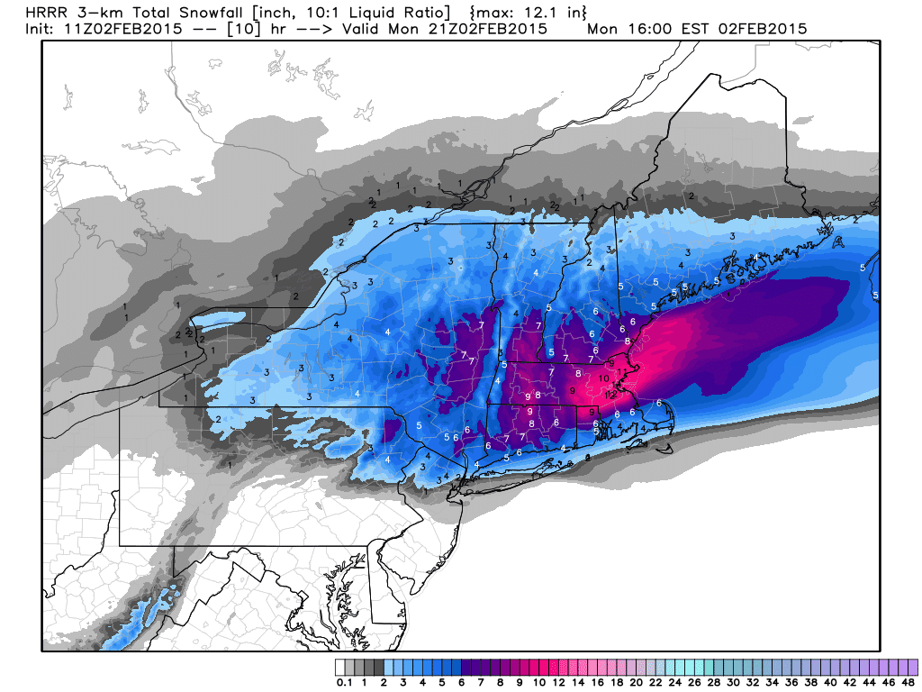
Snow is falling and will accumulate more today in southern New England.

If we go up to 5000ft in the atmosphere you can see the warm air filtering in as indicated by the red lines...

This causes the snow to melt before refreezing when it hits the surface. 

By 12pm today the precip starts to finally move out from west to east..

Although, recent runs of this rapid refresh model are saying some snow can return early this afternoon and not leave until after 2pm due to some back filling precipitation as seen below..


It shows that a few inches of additional snow might fall during this period..

 That would make sense as the storm will be pulling cold air back in aloft at that 5,000ft level towards the end of the event.

Overall the storm is going as I expected and I think when the final snow totals are printed they will be within my ranges. The jury is still out on that.

In any event, be careful today especially north of I-78 as some areas might never go above freezing.The weather pattern stays active for the foreseeable future and later I will focus on storm potential for later this week. 

Thanks for checking in. 

Sunday, February 1, 2015

4PM Quick Update

Forecast is on track. You can find my map from this mornings post. Right now I expect the front end thump of snow to account for several inches of accumulations in northern zones before changeover to ice. Expect changeover around 4-7am south to north in red zone. 

Travel will be very rough tomorrow, especially in yellow box. Do not take this lightly if you live further north.

Update coming after the Superbowl..enjoy the game!

Sunday Morning Storm Update: Adding Some Resolution to the Map


Going to get right to the point this morning:
  • A winter storm will effect our region from late tonight through tomorrow morning
  • This storm will feature all snow changing to sleet, freezing rina and to plain rain for some regions
  • Area in the yellow box expect big ice problems from the sleet and freezing rain
  • The major snows are mainly north of yellow box
I made a tweak to my map and added a dark pink layer for more resolution. Let me take you through each zone and what to expect. 

Green Zone:

Snow quickly changes to plain rain tonight.

Light Pink Zone:

Snow accumulates late tonight into very early am quickly changes over to freezing rain then plain rain by 4am. Expect some minor icing problems in the morning.  1-2" of front end snow.

Dark Pink Zone:

Snow breaks out late tonight into tomorrow am. Expect accumulations of a few inches before the snow changes to sleet then freezing rain by 4-7am. Accumulations of snow and sleet range from 3-6 inches

Red Zone:

Ice is a big concern of mine here. Snow breaks out late tonight and accumulates till about 4am. The snow then changes to sleet then eventually to freezing rain by around daybreak. Snow could return at the end of this storm for this region as we approach noon. Expect snow and sleet accumulations of 5-8 inches.

Dark Blue Zone:

Heavy snow especially to the north of this zone. In the southern part of this zone which is in the yellow box expect sleet to mix in and cut down totals closer to 8 inches. To the north of yellow box this is a  mainly snow event. 

Other Zones:

All snow with accumulations ranging from 6-12 inches.


Any area in the yellow box or above the morning commute will not be pretty. The mixed bag of winter weather should make for very difficult travel conditions especially in the red region. Be careful! 

Although model guidance has wiggled a little I think this map takes into account a slightly colder or warmer scenario given the ranges I have. One thing we can be confident in is surface temps should hold below freezing in many areas despite if liquid is falling from the sky. 

Enjoy Superbowl Sunday the main precipitation arrives later tonight after then game. Expect maybe some light snow during the game. 

Will have an update sometime later today or late tonight after the game. Thanks for checking in.