WINTER OUTLOOK 2023 IS NOW LIVE

The 2023 Winter Outlook

Tuesday, March 14, 2023

Morning Storm Update: On Track

Good morning. Our storm is blowing up off the coast this morning smashing areas like Mass and southern VT with heavy snow. Rain will be changing to snow further south this morning into the afternoon...


Surface is still warm so accumulations will stay in the high elevations of NW NJ etc. Expect 1-3" of snow there. Here is latest model snowfall through today..


Storm bombs off the Gulf of Maine tonight with heavy wind gusts for many...


When its all said and done I think we see a few local 30" reports in areas of the Berkshires and Southern Greens. 

Monday, March 13, 2023

Monday Night Storm Update


Monday Update: Final Forecast for Tonight into Tomorrow

 Good morning. Below is my final forecast for tonight's storm. I adjusted things a little to account for warmer air at the surface. For areas like NNJ PA, its all elevation driven tonight.

Here is updated forecast...


In terms of storm evolution, I like what the model below shows, see loop from tonight into Wednesday morning...


Notice how this model picks up elevation driven snow and rain near coasts. This makes sense to me.

Stay tuned for video update later this afternoon with a play by play! Rush hour should be fine today. 


Sunday, March 12, 2023

Sunday: Updated Forecast for Big Storm

Good afternoon. Below is my updated forecast and video discussion on how I see this storm evolving. This is a rapidly developing situation and there could be surprises. For now, this is my best estimate on how things evolve. There is an outside chance this can hit NYC and NNJ harder but that is not my forecast at this time.

I will have a final update out tonight or tomorrow morning.


Saturday, March 11, 2023

Saturday Update: Big Storm to Slam Northeast Monday Night into Wednesday

 Good morning. Our snowfall this morning was certainty an elevation driven event. The higher elevations of NW NJ reported up to 6" with close to nothing in the lower areas.

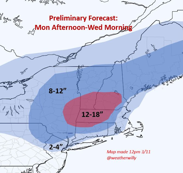
All attention now turns to a big storm that will hit the Northeast early next week. At this time I like New England as the main target zone with potentially some wintery impacts back into NE PA and NNJ. This has the potential to be the biggest storm of the season for many areas. Below is my initial estimate of what I think happens. I will be updating daily...


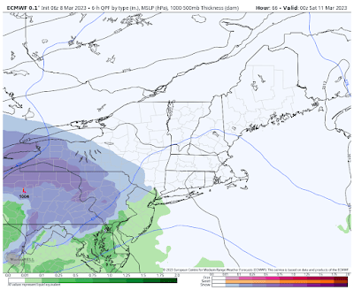
Models have their usual spread but at this time I like the Canadian. I say this because I think it is handling the mid level energy the best and the track it takes is in line with storms similar in history

Here is the evolution below Monday to Wednesday.....


Notice how the low develops off the coast and gets pulled in slamming areas like Mass. WE can easily see totals over 2 feet in spots. My map is conservative for now. Also notice how NNJ has a shot to get in on it. Remember this is just a model projection and things will change. I just am showing this because it closest resembles what I think happens. 

Stay tuned, a lot of coverage to come.

Friday, March 10, 2023

Friday Afternoon: Forecast for Tonight

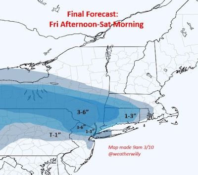
 Below is my final update: Snow hits only the highlands of NJ tonight then some snow makes it more east by tomorrow morning....


We then have a major storm early next week. Stay tuned for who I think gets impacted. 

Thursday, March 9, 2023

Thursday Afternoon Update: Snow for Some Tomorrow Night

Below is my updated forecast for a storm that will move in tomorrow night into early Sat morning. At this time you need to be NW at high elevations to see anything notable with this. Most of NJ i do not think this is a big issue. In fact, most of state sees rain to start with snow at end Saturday morning. My map below is my updated forecast...


Notice the cutoff outside NW NJ. 

Storm moves in after rush out for most as rain and snow to northwest...


As storm redevelops off coast by early Saturday morning, rain can change to snow for many areas...


Travel Saturday morning may be tricky for some.

We then turn our attention to a potential major storm for New England early next week. More to come on this. 

Wednesday, March 8, 2023

Wednesday Update: Snow Hits Areas Friday Night

 Good morning. We have another round of snow that will impact parts of the area late Friday afternoon into early Saturday morning. Below are my initial thoughts on what this system will produce. I will update this daily. After this storm, there could be a larger storm next week, but I think that is more New England focused. With this strong March sun any snow that does fall melts quickly. 

Here is my initial forecast...


Snow approaches from west on Friday. Initially its too warm in lower lying areas to see snow...


By late Friday night snow starts to work more south...


Notice still that the coastal plain of NJ still is rain. The fall line changes to snow at the end which could produce an inch or two down there by early Sat morning as low takes over on the coast...


Stay tuned, daily updates to come!

Monday, March 6, 2023

Monday Update: Narrow Band of Snow Late Tonighjt

 Good morning. We have a wildcard snow event tonight. This means a narrow potentially quick burst of snow is possible for some areas. It is a little hard to predict exactly where this band occurs but I will give you a general idea below...


By just before Midnight, a narrow band approaches through PA...


I would say plus or minus 30 miles of where this band sets up. My gut says the new NAM model above is not a bad idea...


The snow will be heavier out in PA but still should make it to NJ.


Here is the model snow output...


After this period we need to watch late this weekend for a potential storm. I think its back into southern New England but Mid Atlantic is technically in play...


Winter is certaintly not over for New England till towards end of this month.

Friday, March 3, 2023

Thursday, March 2, 2023

Thursday Storm Update: Heavy Snow in Ski Country, Sleet and Rain South

Good morning. Below is my updated forecast for a storm that will move in Friday night through Saturday. Overall anyone south of New England sees mostly rain with this. Some sleet will mix in initially in areas like NW NJ N PA etc. Across far interior (ski country) a heavy snowfall will occur. Sandwiched in-between i expect a mixed bag of snow and sleet. Timing is late Friday night through Saturday. Lets take a look...


A strong storm is developing to our west which by tomorrow will run into high pressure and then redevelop off the east coast...


The storm to the west hits high pressure so it redevelops. However, warm air is still able to work its way in aloft causing mixed precipitation over southern New England...


Notice how its heavy snow in the far interior by early Sat morning. By mid morning Saturday the storm is in its later stages...


Areas in Southern New England should turn back to snow at this time. This is why I have 3-6 inches there.

Storm pulls out by Saturday afternoon.

Stay tuned, more updates to come next 24 hours


Wednesday, March 1, 2023

Wednesday Update: Storm Moves in Friday Night

 Good morning. Our last storm worked out quite nicely, overall the forecast idea was a success.

Moving forward, we have a big storm that will impact the area Friday night into Saturday. At this time I expect an initial burst of snow in areas like NNJ NE PA into southern New England that will change to sleet and some rain. To the north over interior New England, it will be a major snowstorm.

Here is my initial forecast idea...


This is a rough idea and I will update this again tomorrow morning. You can see where I am targeting the heavy snow.

In term of timing this does not look to get started until after 6pm on Friday night. I do not anticipate any rush hour travel impacts. The storm ends late Saturday morning. 

As usual the weather models are offering different solutions. I always make my forecast based on what I think will occur not necessarily what they are showing now. 

The European models idea doesn't seem too bad...


As you can see that initial burst of snow changes to ice (orange) and rain to the south.


Stay tuned, more to come!