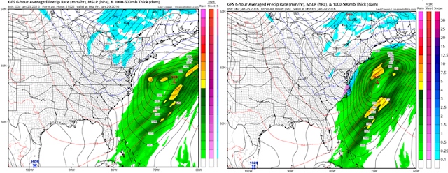
Good morning everyone. Well the saying always goes "snow breeds snow" will that be the case this week? I am keeping my eye on a close call with a coastal storm on Thursday along the east coast. At this time I would assign a 40% probability to this occurring. So basically there is a better chance this misses us out to sea than hits us. Like I said its a very close call though so lets take a look..
The development of this storm starts with a weak low pressure center passing to the west of our area tomorrow..
This will lay down a cold front in its wake. This cold front will give the main storm a boundary to develop along. You can see the front below in blue..
We then have two disturbances to monitor. One is associated with the northern jet stream the other the southern jet stream.
Looking above you can see these disturbances with the northern one being located near WI and the southern piece over the Gulf of Mexico. THE KEY TO THIS THREAT IS THE TIMING BETWEEN THESE TWO DISTURBANCES COMBINING.
Moving on, the southern piece of energy will spawn a low pressure center to develop in the Gulf. As the northern energy tries to dive in, it will guide where this storm goes..
You can see above the combination trying to form. In this model (GFS) it occurs a little too late and the storm stays off shore..
Now as you guys can see this is not projected to miss the area by much. Little changes in those pieces of energy can cause this storm to hit our area. Looking at recent trends you can see the old GFS on the left and new GFS on the right. Notice how the energy is trying to interact a little more on the new run..
Which as I just explained pulls the low closer to the coast as seen below..
We will need to monitor very closely over the next 36 hours and see if this trend continues. There really is not any blocking upstream (HP over Greenland) so that does make it much harder for this energy to combine. Basically it is all 100% timing and we need to "thread the needle".
All the major models do keep this offshore but as you guys can see it wouldn't take much to change this.
Thanks for reading, more to come.


Accuweather posted up an article saying that the next threat for snowstorms (after Friday) will be later in February and early March.
ReplyDeleteI would disagree, we should see a small pullback heading into Feb then I really expect Feb into early March to be the core of our winter. Next storm threat could be around superbowl weekend.I respect Accuweather but disagree. The reasons are the factors behind my winter outlook.
DeleteThanks Willy, nice overall job on the last storm. I enjoy reading your detailed explanations and learning about these systems.
DeleteThank you!
DeleteWilly, with all due respect for the great job that you do . . . I think that we are having one of those really crazy winters, with highly chaotic weather patterns affecting our part of the world. Maybe it's the el Nino energy, maybe it's a touch of global warming, whatever -- but for this winter, it looks really hard to accurately predict anything past 148 hrs. I personally don't like winter storm names, but I'll break down and address the recent event as "Jonas" -- so, the models and advance forecasts for the 2nd half of January didn't suspect a thing, until around the 15th. That's when you first hinted about a possible storm in the offing, but on the 16th you went skiing and didn't sound too optimistic about snow. Yea, I'm a WX NEWBIE, haven't even progressed yet to "newbie" with lower case letters . . . but I have watched the models with much interest this past month, and wow, things change so quickly. All the variance between models and from one run to another. I dunno, but my SWAG is that the rest of the winter is really jump ball. Yea, Nino is declining, but the Arctic is slowly starting to heat up too, the North Pole is seeing a minute or two of daylight. Actually, because of all this chaotic quasi-randomness, we need guys like you more than ever, just because things change so quickly. So definitely keep on doing what you're doing, I'm definitely learning from it. And yes, I would like to know what you see as the major synoptic weather trends for the next 6 weeks. But IMHO, one of those major trends is increased standard deviation, i.e. volatility -- just like the stock market is going thru these days. Interesting theory -- the stock market is volatile and unpredictable right now because the weather is so volatile and unpredictable. Well, thanks for putting up with my SWAG. Jim G
ReplyDeletePS, I am reading something about sudden strat warming for February, that will keep us in the icebox thru early March. Seems like something to keep an eye on. Jim G
ReplyDelete