Good morning. As we approach early next week and evaluate the POTENTIAL for storm development along the east coast, I figured I would start the morning with the spread between various models. The image below I took from a form I read where one of the users put together this interesting graphic of all the models from last night..I hope he doesn't mind that I decided to use it. His twitter handle is @WeatherNut27
Looking above we can see six different models. From top left to right we have the Canadian,Euro, and DGEX. From bottom left to right we have the Navy model, GFS (american), and an alternative version of the GFS. First thing to notice is some models have the storm some do not.
The GGEM or Canadian model is the most robust right now and spins up an impressive coastal storm. The euro still has a coastal storm but is a little more off shore compared to yesterday's run and finally the GFS is still out to sea. The other models are there but they are pretty inaccurate so I don't look at them.
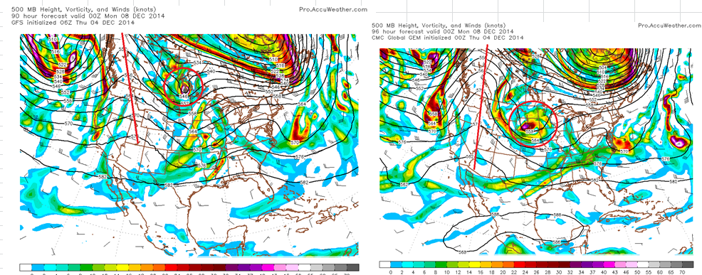
As I mentioned in last nights video this all comes down to how steep the ridge is out west and how much the northern stream energy dives down into the southern stream flow. The more it dives or digs the more the storm amplifies. If the ridge out west breaks down then we have no storm next week and just a rain event Sunday.
The image below shows this difference between the GFS and Canadian..
The red circle is the northern stream energy. Notice how the GFS on the left does not dig as much as the Canadian on the right. All due to the ridge being not as steep on the GFS. The Euro is basically showing a blend of these two right now.
So now we just need to wait for this afternoons model runs to see how this evolves. As I mentioned last night a split flow with cutoff lows is a very difficult situation for models to handle so there will be a lot of volatility. I cannot make a prediction on this yet, I would honestly be guessing. Let's wait another day to study model trends.
More tonight.


No comments:
Post a Comment