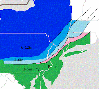
Merry Christmas! It was nice to see some light snow in our northern counties last night. The national weather service was predicting all rain..figures. My idea on the storm for tomorrow night has not changed and I am sticking with the snowfall map I posted yesterday morning. This storm is going to be a very close call. The difference between rain and snow will be 30 miles. Expect the areas that do see snow for it to start as snow then eventually change to sleet and freezing rain. Most of the accumulation on the map below will occur in the initial 6 hour period at the start of the event..
Storm for the 30th is still showing on the models and I will be posting detailed updates this week on the chances of it occurring. In the meantime check in for updates for the storm coming tomorrow. I will be updating frequently during the event.

No comments:
Post a Comment