Good morning, here is the finalized forecast for tonight't light snow event and my updated snowfall projections for the event on the 27th. Tonight light snow snow will spread into the area by 7pm and end by day break xmas morning. Our most extreme northwest counties at higher elevations can see 2-3 inches and north jersey elsewhere expect about a inch of accumulation. South of I-80 I am going with a dusting. Again this is not a big event and just a nice precursor to xmas.
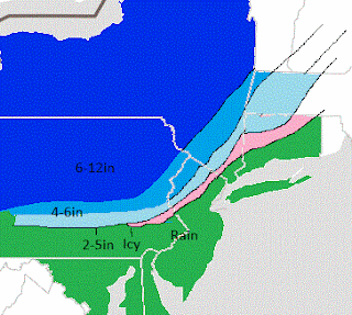
So lets now focus on the event on the 27th. After looking at all the models here is my best guess at what I think will evolve with this storm..
I-95 is a big battle zone and I have ice in that region. The further north and west you go is where there will be the best shot at more snow. I have 2-5 inches from Morristown to Chester and 4-6 inches from Long Valley up in higher elevations into northwestern Sussex county. To the south and east of I-95 I expect rain with this event. The forecast for this storm is extremely complicated. The difference between rain and snow right now literally is within the margin of 30 miles. This makes any slight change in the modeling change these bands I drew. I have looked a lot of models to come up with this forecast but let me show one as an example (the european) to give an idea of why this event is going to be such a close call (from accuweather.com pro site).
The first graphic is the precipitation and the second one is were the rain snow line will be according to this model. Notice how it is holding the cold air in North Jersey. As the system approaches even closer that line moves more north and west based on the track of the low pressure center which now looks to move from Chesapeake bay to Boston Harbor. Any slight shift in this track will influence the snowfall map I published above. The major weather networks will have rain and mixed precip for most of our area with no accumulation. The reason being that since this is such a tough forecast they are going to play it as conservative as possible right to the end then change the forecast 12 hrs before. They also favor the American model since our govt. created it (not as accurate as the European). There is a margin or error right now of literally 40 miles! However, as you know I want to try to actually make a prediction on this website. Everything I have looked at has shown a trend to a colder storm as opposed to yesterday which was showing all rain and I am going to stick with my snowfall map above. If I have to make any adjustments it will not be until later tomorrow. In terms of timing this will start by late afternoon on Wednesday and last until Thursday morning. I will be making brief updates until then on this system.
So how bout that storm for the 30th I been mentioning....Well its still showing and this can be more of a snow maker for all parts of North Jersey. I will keep updating on this situation as well over the next few days. Looks like it can be a widespread 6-12 inch event for parts of the state.
Source:accuweather.com
Keep checking in for updates!


No comments:
Post a Comment