Good morning everyone. Quick post, still away for the weekend but this is it guys. Our strong storm signals for this weekend have strengthened over last 36 hours. If this verifies this would be a true slump buster for all the woes we have had this winter (if you are a snow lover) That is the type of potential we have on the table here. All major model guidance Is showing a significant storm effecting the area. So what's my take? Best shot we have had all year let me summarize.
First let's acknowledge that so far this season every decent threat 5 plus days out has never materialized. My theory on this is that it was because there was too much energy in the jet stream causing things to move along too quickly thus not consolidate.
So as we move towards this weekend will that be the same case. This time I think we have a chance otherwise.
The image above shows the spread from the European ensemble members. I circled how there is a low spread on a western ridge of high pressure. This is a big sign as it would slowdown the flow or this firehose of too much pacific energy entering the field. A low spread means most ensemble members agree on the position and strength of this ridge.
Looking below, the next image shows the upper air set up ahead of this storm at 18k feet. Will save the details for later but this looks excellent to me. There is a strong area of air coming together in eastern Canada this is called confluence and causes high pressure to form to the west at the surface. With the vortex of lown pressure also near eastern Canada in this image, this is a great sign for cold air getting locked in. Ahead of this storm.
So now it really comes down to the timing and nature of the pacific energy that will seed this storm. That energy is still way off the pacific ocean. In the coming days we will see how it is handled and it's impacts on how this major storm threat trends.
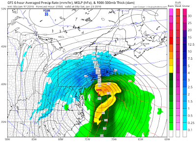
If everything works out perfectly we end with something like this.
This is something we would all be writing home to mother about.
I titled this post the Final Countdown due to the fact if this winter forecast is going to verify we need a big ticket item like tbis storm threat to materialize in next 10 days. Otherwise we are simply running out of time. Nothing like coming down to the wire!
More details tonight or tomorrow morning. Stay tuned.
Excuse any typos this is from my cell phone


No comments:
Post a Comment