In this post I will summarize this storm threat and give everyone what the best and worst case scenarios are. I will also tell you guys what I think is most likely a this current time. I want to make it clear that this storm is not yet a lock. We all saw last year how things can rapidly change and a the difference between 2 feet of snow and 2 inches of snow is a very thin margin. I am not going to make an official forecast till tomorrow due to the complexity of this threat.
Here is a summary of what is going on:
- The area is currently under the threat of a major winter storm
- If this storm materializes the time of arrival would be mid Friday through Saturday
- Areas from DC to Boston have the shot at historical snow accumulations due to a long duration 24hr+ snow event
- Where the actual epicenter of the snowfall is will depend on how the energy in the atmosphere sets up
- This current energy is still way out off the west coast and poorly sampled
- This is the main reason I am not showing any snow maps yet
- The weather channel will give you a snow forecast but it will change every 6 hours- I do not do that.
- There are only two scenarios for this storm in my opinion
- Scenario 1: This storm forms and effects the whole Mid-Atlantic
- Scenario 2: This storm will miss to our south due to energy not consolidating properly along the east coast
- Although scenario 2 is not currently modeled it is not off the table
- This is why the next 24 hours of data will be key.
So now that you have the summary lets jump into details. All major weather models are showing this...
Above is the GFS (American weather model) in 6 hr increments (click to make bigger). Read this from top row left to right, bottom row left to right. You can see the potential we are dealing with here as this storm stalls over our area.
So why is this happening? It all has to due with the set up in the atmosphere at 18k feet where large scale meteorological features are present.
Looking above you can see areas of high pressure in red and areas of low pressure in blue. This storm is developing due to pacific energy getting bunched up along the east coast. This is happening because the jet stream is rising over the west coast causing a sharp trough in the east. Also, this energy is not allowed to just escape out to sea due to the "blocking" or low pressure center over the northwestern Atlantic. This low pressure system up there also helps lock in cold air to make any precipitation that falls snow.
Cold air is one factor that will not be absent. Historically most major storms are always preceded by a big arctic outbreaks. You can see below that is currently the case right now as seen by the cooler colors over our area.
As the storm approaches that vortex or low pressure area in the Northwestern atlantic helps hold this air in place.
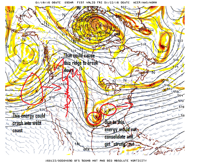
Now where can this go wrong? Let me show you..
Looking above you are seeing all the energy way up in the atmosphere that causes storms. For those of you who are looking for this storm to bust, you need to depend on that western ridge of high pressure breaking down. This would happen if the energy in the pacific behind the storm crashes onto land. This would break down this ridge and allow the energy that forms our storm to not come together and get "sheered" or stretched out.
At this time I do not see much evidence to support this.This next image is by the European Ensemble Forecast System (best weather model). Looking below you are seeing the areas the model is having a hard time projecting as indicated by the green and yellow colors. This is called a spread and means that there are varying solutions of where certain features in the atmosphere will set up. Notice however that the spread is very low with that ridge out west. You can see this by the lack of any bright colors around that axis I drew in. This means the model is currently confident in that ridge forming.
'
So that is the biggest factor in my opinion. You build this ridge you get this storm.
So buckle up guys we might have a big one on our hands here.
I am going to keep track of how all these factors evolve today and have a video update live tonight at 7.
Stay tuned!


No comments:
Post a Comment