Sunday, January 31, 2016
Updates to My Case Study Tomorrow Morning
A lot of action looms post Superbowl..will have my updated thoughts.
Friday, January 29, 2016
Friday Update: Looking at Latest Trends In My Case Study
If you guys have been reading over the last few days I have been discussing how things could get interesting right after the Superbowl. The mild weather will come to an abrupt end and we will have an arctic outbreak on our hands following the Superbowl. It is during this outbreak that I am watching for a storm to develop.
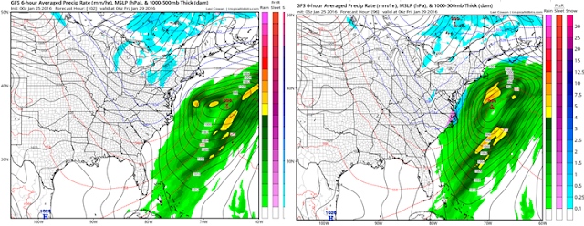
I originally posted this image on Tuesday (all valid week following the Superbowl)..

I then updated this on Wednesday to show the updated evolution. Notice the ridge out west and the blue which means a trough of low pressure in the east.


You can see the model starting to get stronger with the cold air in the east and the ridging out west. The question becomes will a storm develop from this setup.
Right now the GFS ensembles (take main model, vary inputs for potential error, rerun many times- the ensemble mean is an average of those runs) are hinting at a low pressure center developing near the east coast for this period.

So far so good with trends but we have a LONG while to go. We are 12 days out still. Regardless you guys can all see how this can evolve. Much more to come on this. Thanks for reading.
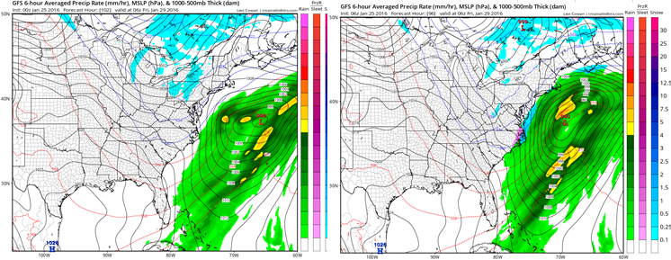
I originally posted this image on Tuesday (all valid week following the Superbowl)..

I then updated this on Wednesday to show the updated evolution. Notice the ridge out west and the blue which means a trough of low pressure in the east.

Today's updated runs of the GFS ensemble show this below..

Right now the GFS ensembles (take main model, vary inputs for potential error, rerun many times- the ensemble mean is an average of those runs) are hinting at a low pressure center developing near the east coast for this period.

So far so good with trends but we have a LONG while to go. We are 12 days out still. Regardless you guys can all see how this can evolve. Much more to come on this. Thanks for reading.
Thursday, January 28, 2016
Thursday Morning Weather Discussion:A Post Superbowl Case Study
Good morning everyone. I mentioned in my last post how I expect this current pullback in temperatures not to last long. My target period for at least a return to colder temperatures is post Superbowl. I also am watching the potential for a storm to develop.
I put this image out on Tuesday morning from the GFS ensemble...
 Over the next several days I want to track the trends in this scenario so we can all watch it evolve. This is obviously all pure speculation but I thought it would be fun considering the pattern looks to get ripe again.
Here is the latest run valid around the same time..

The whole idea here is that a big storm in the middle of next week (focused on the plains states) will sweep in very cold air. In its wake a western ridge pumps up and energy dives down into the trough over the east potentially consolidating into a storm sometime the week of the 7th.
This is a model ensemble so the colors will look more stretched out and not as bold in these maps. However as we get closer to this period we will see if all that blue energy focuses along the east into a storm.
That is all for today, lets watch this all evolve.
I put this image out on Tuesday morning from the GFS ensemble...

Here is the latest run valid around the same time..

The whole idea here is that a big storm in the middle of next week (focused on the plains states) will sweep in very cold air. In its wake a western ridge pumps up and energy dives down into the trough over the east potentially consolidating into a storm sometime the week of the 7th.
This is a model ensemble so the colors will look more stretched out and not as bold in these maps. However as we get closer to this period we will see if all that blue energy focuses along the east into a storm.
That is all for today, lets watch this all evolve.
Tuesday, January 26, 2016
Tuesday Morning Weather Discussion: A Brief Pullback Followed By Winter's Return
Good morning everyone. Quick post today. I will outline some thoughts that I will drill down more on in the coming days. First off, our storm threat for the end of this week is off the table. As we then head into next week things should really moderate with above normal temperatures for most of the week. This warm up is being labeled by many as the end of winter. I do not buy that at all. Remember this is what I expected for February per my winter outlook..
 This truly was always supposed to be the heart of our winter- February though early March. I based this forecast on a variety of variables but in most simple terms this is very common for El Nino winters (back loaded).
This warm up below next week is just a pattern reload in my opinion. Image below is Jan 30th to Feb 4th. The red is warmer conditions the blue is colder.


I expect this to stay locked in for most of Feb. In fact, if I had to speculate on our next winter storm threat it would be around the Super Bowl time frame.
I am keeping my eye on energy diving down towards the gulf with a fresh injection of cold air ahead of it shortly after Superbowl Sunday..

The image above is from an ensemble but shows the general idea here. We will keep revisiting this as the days go on and study trends.
In any event, if you guys need even more convincing that this winter is not over look no further to what is projected to occur in the stratosphere.
 That is major stratospheric warming being projected. Its effects would be felt from Mid Feb through March with colder conditions. Do not have time to cover this right now but it is a MAJOR factor here.
Thanks for reading.

This warm up below next week is just a pattern reload in my opinion. Image below is Jan 30th to Feb 4th. The red is warmer conditions the blue is colder.

However, not so fast. All models are indicating a flip towards a pattern more like my projections by say around Super Bowl weekend..

I am keeping my eye on energy diving down towards the gulf with a fresh injection of cold air ahead of it shortly after Superbowl Sunday..

The image above is from an ensemble but shows the general idea here. We will keep revisiting this as the days go on and study trends.
In any event, if you guys need even more convincing that this winter is not over look no further to what is projected to occur in the stratosphere.

Thanks for reading.
Monday, January 25, 2016
Monday Morning Weather Discussion: Evaluating a Storm Threat for Thursday
Good morning everyone. Well the saying always goes "snow breeds snow" will that be the case this week? I am keeping my eye on a close call with a coastal storm on Thursday along the east coast. At this time I would assign a 40% probability to this occurring. So basically there is a better chance this misses us out to sea than hits us. Like I said its a very close call though so lets take a look..
The development of this storm starts with a weak low pressure center passing to the west of our area tomorrow..

This will lay down a cold front in its wake. This cold front will give the main storm a boundary to develop along. You can see the front below in blue..

We then have two disturbances to monitor. One is associated with the northern jet stream the other the southern jet stream.
 Looking above you can see these disturbances with the northern one being located near WI and the southern piece over the Gulf of Mexico. THE KEY TO THIS THREAT IS THE TIMING BETWEEN THESE TWO DISTURBANCES COMBINING.
Moving on, the southern piece of energy will spawn a low pressure center to develop in the Gulf. As the northern energy tries to dive in, it will guide where this storm goes..

You can see above the combination trying to form. In this model (GFS) it occurs a little too late and the storm stays off shore..

Now as you guys can see this is not projected to miss the area by much. Little changes in those pieces of energy can cause this storm to hit our area. Looking at recent trends you can see the old GFS on the left and new GFS on the right. Notice how the energy is trying to interact a little more on the new run..

Which as I just explained pulls the low closer to the coast as seen below..
We will need to monitor very closely over the next 36 hours and see if this trend continues. There really is not any blocking upstream (HP over Greenland) so that does make it much harder for this energy to combine. Basically it is all 100% timing and we need to "thread the needle".
All the major models do keep this offshore but as you guys can see it wouldn't take much to change this.
Thanks for reading, more to come.
The development of this storm starts with a weak low pressure center passing to the west of our area tomorrow..

This will lay down a cold front in its wake. This cold front will give the main storm a boundary to develop along. You can see the front below in blue..

We then have two disturbances to monitor. One is associated with the northern jet stream the other the southern jet stream.

Moving on, the southern piece of energy will spawn a low pressure center to develop in the Gulf. As the northern energy tries to dive in, it will guide where this storm goes..

You can see above the combination trying to form. In this model (GFS) it occurs a little too late and the storm stays off shore..

Now as you guys can see this is not projected to miss the area by much. Little changes in those pieces of energy can cause this storm to hit our area. Looking at recent trends you can see the old GFS on the left and new GFS on the right. Notice how the energy is trying to interact a little more on the new run..

Which as I just explained pulls the low closer to the coast as seen below..
We will need to monitor very closely over the next 36 hours and see if this trend continues. There really is not any blocking upstream (HP over Greenland) so that does make it much harder for this energy to combine. Basically it is all 100% timing and we need to "thread the needle".
All the major models do keep this offshore but as you guys can see it wouldn't take much to change this.
Thanks for reading, more to come.
Sunday, January 24, 2016
Eyeing End of Work Week
Models today are trying to put me back to work. No rest for the weary!
Writeup coming tonight or tomorrow morning.
Writeup coming tonight or tomorrow morning.
Sunday Morning: Digging Out
Below are reported snow totals for the blizzard of 2016. I reported 20 inches close to where you see the 33 inch mark in the middle of northern NJ. NYC looks like they broke their all time record! Tonight after football I will have a storm summary and thoughts on what to expect on the week moving forward.

As far as my backyard, I think this has to be the picture that takes the cake..

Thanks for everyone for checking in over the last few days, it made this a lot of fun! More to come this winter!

As far as my backyard, I think this has to be the picture that takes the cake..

Thanks for everyone for checking in over the last few days, it made this a lot of fun! More to come this winter!
Saturday, January 23, 2016
6pm Update: Completely Buried
Storm will start to wind down over next few hours west to east. When it is all said and done the totals in the hardest hit areas will be 2 to 2.5 feet! Where I am currently, I measured 28 Inches as of 5 pm. Just insane and a storm we will all remember for ever.
I will have a summary post out either late tonight or tomorrow morning showing the final aftermath.
We then will turn our attention to our next storm threat Thursday. More to come!
I will have a summary post out either late tonight or tomorrow morning showing the final aftermath.
We then will turn our attention to our next storm threat Thursday. More to come!
2pm Update: The Height of This Storm is NOW
Here we go guys this is the height of the storm lasting until late tonight for most areas. Snow will be falling 2 plus inches an hour in many spots! If you think you have a lot of snow now just wait!
Video below is my latest live footage..enjoy! Next update around 6pm.
Check out the snow bands on this latest radar imagery..unbelievable! 3" an hour snows in spots!

Video below is my latest live footage..enjoy! Next update around 6pm.
Check out the snow bands on this latest radar imagery..unbelievable! 3" an hour snows in spots!

EPIC is the Only Word Here: The 10am Update
Words can not describe the storm that is underway. Two short videos below. First video is my live footage in the brunt of the storm and the second is the updated weather projections. You don't want to miss this guys! Wait till you see updated snow projections!
Next update around 2 pm
Live footage...
Next update around 2 pm
Live footage...
Very quick storm update below..you do not want to miss this. Old school Weather Channel local forecast style. I show updated totals..
6am Morning Update: Raging Storm Underway, It Will Only Get Worse
HISTORICAL BLIZZARD UNDERWAY, LIKELY TOP 5 IN HISTORY
*1-2 Feet of Snow, Locally More*
*1-2 Feet of Snow, Locally More*
<<<<<<<<<<<<<<<<<<<<<<<<
Good morning everyone. History is in the making right now. Our storm is cranking up and conditions will only continue to deteriorate more as we head towards late morning. Areas to our south in the Baltimore DC area already are working on their second foot of snow. You can the heavy snow banding currently developing as seen by the dark green contrasts in the image below.

These bands will continue to strengthen and peak out as we get into late morning into the evening. This is where areas in central, NNJ, and NYC can see snowfall of 2-3 inches per hour!
Right now our low pressure center sits just south of the Delaware Bay. I highlighted all the moisture it is throwing into the cold air over our area. This will cause intense snowfall to grow as the morning moves on. The low will stall out, strengthen then move gradually NE. This means all the snow down south on that 45 degree angle still needs to move through!

The height of this storm will be late this morning into this evening. Check out the INTENSE band of snow that I expect to develop over the whole state of NJ into NYC. This will cause snowfall rates of 2 to 3 inches an hour! All out blizzard! 1 to 2 feet of snow can be expected for most areas with locally more.

Next update will be around 10 am. Will likely be a video update.
Friday, January 22, 2016
Friday Evening Storm Update: This Will Be One For The Record Books
We have an historical storm underway. My latest video tells you everything you need to know. There will be live footage to come over the next 24 hrs along with frequent twitter updates @weatherwilly.
Here is my updated map, I had to bring heavy snow more north..

- Historical east coast snowstorm on track and closing in fast
- I am increasing snow amounts for our northern zones
- By midnight it is snowing in all areas
- Height of the storm is late tomorrow morning through tomorrow evening
- It can be snowing 1-3 inches per hour at times
- Winds will be gusting to 40mph inland and over 60 at the coast
- Expect horrible visibility and near impossible travel conditions
- Storm pulls out late tomorrow night.
Here is my updated map, I had to bring heavy snow more north..

Friday Morning Storm Update: Buckle Up, The Blizzard of 2016 Just Tightened It's Crosshairs
*MAJOR WINTER STORM TO EFFECT REGION TONIGHT INTO SUNDAY MORNING.*
What a crazy experience this has been tracking this weekends winter storm. I have never seen such large short term swings in the models before a major storm. I discussed the reasons why in my video last night. Regardless, it really kept me on my heals. After looking at the latest trends last night I am feeling very good about my final forecast. In fact, at this time there is just as much a chance this can over produce in the northern zones as under produce.
Here is my latest summary:
- A major winter storm is currently approaching our area from the southwest.
- Current satellite and radar imagery supports a storm that will continue to strengthen and rapidly deepen off the mid Atlantic coast
- Snow will start to break out very late this afternoon in the DC/Baltimore area
- The snow will gradually work its way north and reach the NJ area close to midnight
- The height of this storm will be from late tomorrow morning through tomorrow night
- Expect gusty winds with blizzard conditions at times in our hardest hits areas
- Snowfall rates for many areas will exceed 1-2 inches per hour making for extremely poor visibility and driving conditions
- At the coast, winds will be the strongest and flooding is a big concern along all of the beach areas
- Snow will begin to taper off southwest to northeast around 1 am Sunday as storm finally moves off shore
- A special play by play breakdown of this storm will be live tonight at 730
- Will discuss hour by hour impacts for all regions
Here is my going forecast:

The National Weather Service has the winter storm and blizzard warnings now live..

The thoughts about the northern cutoff of this system remain the same. It is still going to come down to where the strong banding of snow sets up. The model trends last night have brought the storm more north. In fact, the European model now looks exactly like my map with its snow printout! I think if anything this will overproduce not under produce in the areas in purple and dark blue on my snow map. We shall see, the numbers I put in those zones still make the most sense to me from a forecasting perspective.
Right now the NAM model is the most aggressive with bringing the storm the most to the north.

This model is known for overdoing snow amounts. However I am blown away with how consistent it has been over last 24 hrs. It now seems the other major models are coming towards it not the other way around. Take a look at that intense precipitation coming in off the ocean. That is the snow banding I am talking about where you can see 1-2 inches per hour of snow! My gut tells me the NAM is not too far off with this idea. However, I do still think the storm settles a little more south that what this projects. The next short range model below I think has the best idea valid the same time..

Notice it still has that large band of heavy snow but is slightly more south. This is what you guys might end up seeing when you turn on the radar on Saturday afternoon.
I can not emphasize enough how impressive the dynamics of this storm are. All the ingredients are there to produce explosive snowfall for some areas Saturday. It is because of this, that when we look back this should be one for the history books.
The image I showed the other day describes why this storm will have such impressive snow banding.
Here it is again below..

Now what would the worst case scenario for snowfall be? I URGE A BIG WORD OF CAUTION HERE BECAUSE THIS IS LIKELY WAY TOO EXTREME BUT HERE IS THE LATEST NAM MODEL SNOW PRINTOUT. I will emphasize again that this model always overdoes the snow amounts but I am only showing it because it is very rare you will ever see a model print out this much snow. The beauty of it alone is worth the look.


So the time to take preparations would be now as the worst of mother nature targets our area.

To bring everyone back to reality, here is the best case scenario (less snow) to balance this out:

Both are not likely to me. Stick to the snowfall map I made and I do not think you will be let down.
So the time to take preparations would be now as the worst of mother nature targets our area.
Tonight's video will be more focused on play by play of this storm. I will show where I expect impacts to be hour by hour and how this is developing in real time.
Stay tuned, will be live at 730!
Thursday, January 21, 2016
Thursday Night Update: The Final Forecast
Good evening everyone. I have crunched the latest numbers and arrived at my final forecast for the 1st major storm of 2016. This will be one for the record books if you live in the Baltimore Washington area!
For areas in northern NJ, NE Pa, Southern CT it will come down to the wire. You could end up from anywhere between 2 and 12 inches. I tried my best to estimate where the snow cutoff will be.
Here are updated storm highlights. I also made a video for those of you who enjoy my company. Great details included for those of you who are interested.
So lets get right to it. Here was my original preliminary prediction..

And now my final call..

Notice how I have a sharp cutoff in totals. This is due to the banding I expect to develop. For the most part to the south is pretty consistent with my original ideas.
More details in the video below. I will do a write up tomorrow morning and a play by play tomorrow night as the storm approaches.
Note: For those paying attention to details meant to say upper levels of atmosphere colder than surface when explaining the upper level low.
For areas in northern NJ, NE Pa, Southern CT it will come down to the wire. You could end up from anywhere between 2 and 12 inches. I tried my best to estimate where the snow cutoff will be.
Here are updated storm highlights. I also made a video for those of you who enjoy my company. Great details included for those of you who are interested.
- Major winter storm impacts the area tomorrow night through Saturday
- Storm will feature heavy rates of snowfall and gusting winds
- Near the coastal areas expect some mixing along with gale force wind gusts Saturday
- Beach erosion and some flooding are a concern
- This storm will have an intense cutoff in accumulations to the north.
- Most of the analysis I did today was on where this will be.
- My updated map reflects those thoughts
- The cutoff will be due to an intense snow band developing Saturday over north central NJ extending into PA and long Island. Anyone to the north of this band will be cut off from heavy snow due to sinking air. This cutoff should happen somewhere in NW NJ. This will cause forecast headaches and upset snow lovers.
- Believe it or not models still are trying to figure out where this sets up!
- This will come down to the wire for northern zones
- I tired my best to show this in my map.
- More in my video on this
- For areas in Baltimore/DC this storm will be historic. Over a foot of snow is very likely.
- NYC I really do believe you are in the game for this system.
So lets get right to it. Here was my original preliminary prediction..

And now my final call..

Notice how I have a sharp cutoff in totals. This is due to the banding I expect to develop. For the most part to the south is pretty consistent with my original ideas.
More details in the video below. I will do a write up tomorrow morning and a play by play tomorrow night as the storm approaches.
Note: For those paying attention to details meant to say upper levels of atmosphere colder than surface when explaining the upper level low.
Thursday Morning Update: Final Forecast Map Out Tonight, Some Thoughts This Morning
Good morning. We are now within 36 hours of our storm and models for the most part are starting to lock everything in. Areas from DC to Philly are really looking good right now in terms of significant snowfall potential. Also, I am getting increasingly concerned with coastal areas and beach erosion and surge due to the very strong winds this storm will bring with it. So before we go any further here is the latest:


- Major winter storm on track to effect the area Friday night through Saturday
- Storm arrives late Friday night and ends late Saturday/Sunday morning
- For areas in the epicenter of this storm a foot or more of snow is likely
- For coastal areas winds can gust up to 50 mph, 40 mph inland during the day Saturday
- Beach erosion will be a big concern since we are nearing a full moon
- There is still a very big question mark about how north this storm gets
- I will talk about this below
- Due to the sharp northern cutoff in precipitation that ALL models are projecting 30 miles will mark the difference between significant snow and a few inches.
- Where this northern edge sets up will all come down to the placement of the upper level low pressure center and how close it stays to the coast
Ok so lets discuss what is going on very clearly. First here was my initial snow map..

This will be updated to a final map in my evening update. I can tell you right now as I mentioned last night that I will be cutting down the light blue (5-8") zone. I will also be tweaking the areas in southern CT and NNJ to reflect where I target this sharp northern cutoff to be. At this time it is likely to boarder extreme NW NJ through south central CT (near I-84 corridor). THIS WILL BE THE MOST CONTROVERSIAL PART OF MY FORECAST.This zone literally is the hot debated topic right now. Some will be happy some will be upset but I will do my best to make it accurate based on today's data and how it relates to my final thoughts on how this storm evolves.
I also will increase the resolution of this map meaning there will be narrower bands on the map to really hone in on the hardest hit areas. This will be especially important for all areas north of I-78 that are right on the brink right now between a lot of snow and a few inches.
So lets go through some model updates.

Looking above you have GFS top left, Canadian top right and NAM model on the bottom. I circled on each model the factor that is going to make or break the northern zones- where does a deformation band of snow end up setting up. A deformation band of snow is a very intense area of lift in the atmosphere due to air getting stretched apart, it can cause snowfall rates over 2 inches and hour and will make or break this forecast. Notice on every model the band is in a slightly different spot. For example on the GFS model is is south of I-78, the Canadian model just over I-78 extending a little north and the NAM (most aggressive as always) has the band getting into the southern CT. THIS IS THE FORECAST KEY. The positioning of the upper level low and High pressure to the north will determine the position of this band. Anyone who is just off its northern edge will see a rapid decrease in snow amounts due to sinking air (what rise must fall).The models right now are trying to determine where this sets up. Believe it or not they will CONTINUE to jump around a little where in one run Sussex county NJ can have a foot where in another they have 2 inches. This is because this is a micro aspect of the atmosphere and it very hard to predict outside of 24 hours.
Hey Will how about the European model? Yes my friends the European is south with its northern edge of heavy snow banding. If fact, it cuts off the heavy snow just south of Newark NJ! Can this happen? Absolutely, but I want to make it clear I do not think that will verify. Its ensemble prediction system has many members still well north of the main model. This to me says it would be too early to make that call. I am sure if I am wrong I will take heat from many people but my honest assessment is that this will make it to NNJ/SE CT. I am basing that on history and how similar storms have behaved along with ensemble guidance.
Regardless of what happens today in model land. My map tonight will reflect my most accurate attempt to give you guys the best final forecast 24 hours before this event starts.
Stay tuned. I will have the final forecast up around 630pm.
Wednesday, January 20, 2016
Wednesday Night Video Update: Getting Ready to Finalize Forecast: Balt/Wash/Philly a Lock
Our winter storm is now imminent. The only questions that remain are how far north does the precipitation shield get. At this time I still like I-84 but this will have to be monitored closely. There is no doubt we will see a very sharp cutoff in snow. The difference between a foot and two inches will be 20 miles in northern zones. I will put out my final snow accumulation map tomorrow.
This is still my going forecast. The light blue zone will likely be adjusted (at risk area).

Enjoy the video.
This is still my going forecast. The light blue zone will likely be adjusted (at risk area).

Enjoy the video.
8pm Prime Time Update..Storm Now Imminent
Going to start to focus now on the finer details.
Stay tuned!
Stay tuned!
Wednesday Morning Storm Update: Back on Track
Good morning! After the model drama of yesterday, last night provided a sense of releif as it relates to what I expect for this system. As I mentioned last night these models always move back at forth approaching a big storm as they try to pin point the track of this storm. Its important to filter out that noise and anticipate where things are going to trend. At this time I feel very good about the ideas I laid out. In fact, you will most likely see a final forecast issued by me tomorrow . Below are my updated thoughts:


- Major/Historical winter storm effects whole region Friday night thought Saturday
- All areas from Washington DC to NYC should feel the brunt of this system
- Expect periods of heavy snow and wind Saturday with significant snow accumulations
- The height of this storm should be Saturday afternoon into Saturday night
- This will be a long duration event lasting up to around 24 hours.
- There will be a very sharp cutoff in snow amounts most likely around the I-84 corridor or slightly south of that
- The southern trends in the models have worked their way back north overnight
- I still expect these models to move around more but overall I think they settle in with what my updated map has below

You will notice I made two tweaks to this map. I highlighted the area of 5-8 inches to the north and have that as a potential risk for much lower amounts. Also, I inched up the mixing line (pink) into SE NJ. I still expect good snow amounts there but as this storm approaches some warm air might filter in. Otherwise I really like the other amounts I originally had. As I mentioned, I will issue a final map sometime tomorrow.
The American model went all out in its run last night copying the blizzard of 96! I think it might have been a little extreme and its most recent run, which is no small potatoes by the way, is more realistic. Below is the storm in 6 hour increments..

Unbelievable to see how this just stalls off the Delaware bay! This is why some areas I really believe can see over 24" of snow with this storm. Tomorrow I will try to nail down potential areas that can see the localized jackpot amounts.
The beloved European model which I cannot show shifted about 75 miles north from its big dud of a run yesterday. This was a huge trend and needed to be seen. It brought the heavy snow back into NNJ. I still think it might be a little too south and accumulating snow can work its way into CT and extreme SE Mass. My map reflects that.
Regardless though, that sharp cutoff should verify. Below shows example of what I mean courtesy of the Canadian model.

If you notice guys I blend a lot of models when trying to make this forecast. I think the Canadian in this case has the best idea for its precip printout. Notice the sharp cutoff around I-84. 20 miles can be difference up there between no snow and several inches.
Here is another image showing the warm air that can work its way into the storm at 5000ft..

This is just the nature of a storms circulation. Yes we have a cold high pressure system to the north funneling in cold air but this storm should inch just close enough to give those areas I highlighted in pink some mixed precipitation. Could this mixing line move more north? It could but that is not my forecast at this time.
The next image below shows you guys the unbelievable moisture circulation associated with this storm...

If you are a fan of weather this is right out of a textbook for a historical winter storm. Notice all the moist warm air this storm brings up and throws into the cold air being supplied by the high pressure. This is how you get feet of snow!
So there you have it guys I am sticking to my guns with the going forecast. I firmly believe folks rather see an actual forecast made rather than flip flopping. At this time my confidence is growing. I will make any adjustments if necessary tomorrow. Hopefully no big curve balls get thrown today! Mother nature is never a guarantee.
As usual a video breakdown will be up around 8pm tonight. Stay tuned! This can get exciting!
Tuesday, January 19, 2016
The Tuesday Night Storm Update: Drama In Model Land, Keeping a Steady Hand
Good evening everyone. What a day today model land. Our major storm has trended south on many of the major models. I am not completely surprised as I mentioned the risk of this in my morning post. It does not mean that I am changing my forecast. In the video below I break down why this happened, my thoughts on if it will verify, and what to expect in terms of impacts.
This is always the story with big storms, they never are a lock up until 36-48 hours before a event. The reasoning is the models need to sort out a lot of variables. The difference between 2 feet and 2 inches in NYC literally is a pin prick when it comes to how energy is handled. It all comes down to trends. At this time a trend has started south, however, we are still over 3 days way. This means things can also flip back north. As a forecaster you need to anticipate how things will change not where they currently are. You base this on how the atmosphere is set up. At this time I believe the whole tri-state area is still in play. My snowfall map factors all of this in. If necessary I will update this.
The next 24 hours are key. Will the southern trends continue? Only mother nature knows.
More in the video.
Tuesday Morning: The Preliminary Prediction
Good morning everyone. Thanks for everyone who checked in yesterday the site hit a new time high for visitors. Our major if not historical east coast storm remains on track for this weekend. However, I have begun to now hone in on the finer details and took a first shot at putting together a snowfall prediction. This eventually will be updated to a final forecast as the event is within 36 hours.
So here is a summary of where we stand right now:


So here is a summary of where we stand right now:
- A major east coast storm will effect the area from late Friday night into very early Sunday morning.
- This storm has the chance to be historic due to its duration and potential snowfall rates
- This storm will feature periods of heavy snowfall and windy conditions especially near the coast.
- The height of this storm looks to be late Saturday afternoon into Saturday night for the NYC area
- As stands there is some spread in the models for the epicenter of this storm.
- Some take the heaviest snow more north some take it more south
Here is my preliminary snowfall forecast. I will update this as we get closer to the event

You will notice I have a cut off in snowfall to the north. This is due to my idea that this storm does get a little suppressed for areas in southern New England. I could be wrong but I am trying to anticipate where things might trend not where they currently stand. If necessary I will update to higher totals if I am wrong.
My concern lies below:

Left image is old European ensemble model right is new. Notice the circled area. On the new run this vortex is pressing more and is stronger. This can cause the storm to stay a little more south if this trend continues. Just something to keep and eye on.
As I mentioned in the video last night this really reminds me of the Blizzard of 96 but maybe a tad bit more south. Look at the comparison below..

Left is 1996 upper air pattern right is this storms upper air. Pretty amazing stuff!
So lets see how this trends today. I want to make sure i do not see any further movement south than I anticipate.
I will have another video update at around 830 tonight with updates.
I will have another video update at around 830 tonight with updates.
Stay tuned!
Subscribe to:
Posts (Atom)