WINTER OUTLOOK 2023 IS NOW LIVE

The 2023 Winter Outlook

Thursday, February 28, 2013

Let It Ride

Good Morning. I have mentioned numerous times in the last two weeks how favorable the pattern has been for a big east coast snowstorm. Yet, dates of these possible events have come and gone. That's the funny thing about the weather, the atmosphere can be in a perfect setup but at the end of the day it will still snow where it wants to snow. This year it wants to snow in new England not in the mid Atlantic. This has made it very frustrating to see so much potential week after week and watch that potential dissolve for our area as the target date comes closer. What I am trying to say is sometimes the fundamentals of the atmosphere can be strong to support a big storm developing, but it just does not happen. Its like owning a stock that on paper is a great bargain yet these strong fundamentals still do not result in you making any money. That's how parts of this winter have felt this year. 

Don't get me wrong the pattern is very favorable up until mid march for a mid Atlantic snowstorm to develop. I look at the models and now they hint at March 6th as being the day, not the 4th. Considering I will be traveling out west on March 6th, it will prob snow knowing my luck. Right now, we just have to lets things play out and when spring finally breaks look back and make the final call on how winter was. If we end up a classic blockbuster storm to end this winter, it will be funny to see how everyone will forget about the lack of snow for NJ most of the winter. 

So you might be thinking whats the deal lately? First March 1st, then March 4th, now the 6th? The fact of the matter is, I can only make predictions based on what the data shows me. This year the models have been very inconsistent. Take the European for example, for some storms such as the big blizzard a few weeks back it nailed. Yet other times it has flopped. The same goes with the gfs. If anything, I hope by reading these posts you saw through my analysis why storms could form on these dates. Its more than just looking at if a storm shows up on a model, and I try to show that by using the upper air charts that more or less show if there is "potential" despite the model print out. I hope by doing that people can lean how these storms can develop. 

Lets let it ride until mid march. I will keep updating on any potential storm threats up until then. As difficult as it is to try to forecast a storm 7 days out, and put a little skin in the game (unlike the overly conservative public weather outlets) the more exciting it will be when and if it comes to fruition. Thats why I hope people choose to follow this blog. To get a perspective you will not find anywhere else.

More updates tonight..


Note to Viewers: Do not hesitate to leave comments with any questions or concerns. To leave a comment click on title of a post, then at the bottom you can type your comment in. Also, you can now become a member of this blog by clicking on "followers" on right hand pane.


Tuesday, February 26, 2013

Tuesday 7pm Update

I find no reason to believe that the high elevations will not see some snow with this system before midnight. Here is the radar right now...


Precip will begin to fall any min and the green will turn to blue in North Jersey. As the precipitation begins to fall it will "pull" the cold air down from aloft and result in light rain turning to snow above 1000ft. This snow can accumulate a little then it will change back to rain around midnight.

Next update later once I can see the precip start in my area.

Update on Last Nights Post

Looks like cold air will hold for first 6 hours of event tonight at 1000ft plus. A few inches in these locations is in play, and lower elevations will see frozen Precip start around 7 and then turn to plain rain. Change over will occur around midnight the higher you go.

More tonight check in

Monday, February 25, 2013

Monday Night: Storm Tomorrow Can Surprise in High Elevations

Wanted to focus tonight on the storm coming through our area tomorrow night. This will start off as snow/sleet/freezing rain for our northern counties, but there are some indications that we can see some accumulating snows at elevations over 1000 ft in North Jersey. Here is the latest accumulation printout from the North American Model...


Notice how it looks spotty, that is because it is showing the heaver snows over the mountains of pa, ny and even north jersey to an extent. Dark purple to pink is 6-10 inches. Keep in mind that there are some models showing a warmer storm with not much at all for accumulations in North Jersey as seen with the GFS snow print out..


The timing of this event is tomorrow night around 6 pm till about late Wednesday morning. Following this event, we will see snow showers for most of the remainder of the week and can pick up a dusting to an inch in some places.

Right now I am leaning towards a compromise between the two models shown above. I think we will see some accumulating snow above 1000 ft but not much more than a few inches, so figure I am going with a compromise between the two snowfall charts. Up in NY, PA, and New England however, I think the first snow chart is pretty accurate and some areas will see a foot or more from this especially in the ski areas. That makes this weekend ideal to go skiing up north. 

After this week I mentioned the chance at one more big mid Atlantic storm before this winter ends. That is still on the table and March 4th bears watching. As I explained in video last night the pattern is fully loaded and is capable of producing a blockbuster snowstorm before March 15th. That is due to a setup looking like this...


In a pattern shown above you have temperatures well below normal for the whole east coast even temps that can break freezing down in Florida  A trough this deep (shown by blue and green over east coast) is very rare and has resulted in our best snowstorms over the past 50 years. Whether or not that happens is out of my control  I just want to show the potential is there and if it does not happen its worth getting disappointed over if you like snow. Lets see what happens, I will keep following this trend.

Quick update tomorrow morning after I can see the European model for tomorrow storm and also the longer term..


Note to Viewers: Do not hesitate to leave comments with any questions or concerns. To leave a comment click on title of a post, then at the bottom you can type your comment in. Also, you can now become a member of this blog by clicking on "followers" on right hand pane.


Update Tonight at 11:30pm: Alot to Talk About

Tomorrow night we might see a higher elevation snow event for our northern counties. Very interesting setup.


Note to Viewers: Do not hesitate to leave comments with any questions or concerns. To leave a comment click on title of a post, then at the bottom you can type your comment in. Also, you can now become a member of this blog by clicking on "followers" on right hand pane.

Sunday, February 24, 2013

Sunday Night Discussion


There is alot to watch over the next 10 days. Only a few variables need to change for our area to get a big storm. This is not wishful thinking, and I will show in the video why we are in a favorable pattern based on how the current atmosphere setup compares to a few dates in history. 

March 1st is still on the table and we have another shot at March 4th to close out this winter with some decent snow.

Next Update Monday night..

Saturday, February 23, 2013

Next Update Sunday Evening

Not much to add until later this weekend. As I mentioned today's event is nothing to be concerned about just rain for our area. Later tomorrow I will take another look at storm potential for end of next week.

Friday, February 22, 2013

Friday 5pm Update

Good evening..In the video I summarize the upcoming storm system for Tomorrow which will not be a big deal for our region and also give some hints on what CAN happen around March 1st.

As for updated accumulations here you go: Had to adjust to less for New England due to storm trending more out to sea on latest model runs


Northwest Jersey at elevations over 1000ft will see the snow hold a little longer before changing to freezing rain, plain rain, then back to snow. All of north jersey will see the rain end as some snow showers tomorrow night. Do not expect any accumulations for most of the state.

Update Coming Later This Afternoon

Check in around 4pm. I will tweak if necessary for the storm tomorrow and mainly focus on the very active weather we will see next week on the east coast, including a possible big storm. March looks like it wants to hold winter this year. I am thinking we have another 3-4 weeks until we see spring weather. 

Thursday, February 21, 2013

Snowfall Map For Sat into Sunday Morning

Here is my initial estimate of snowfall for the system coming Saturday into Sunday Morning. Snow will overspread our area sat morning but change to rain then back to snow showers. Video on potential BIG March 1st Storm Coming tomorrow morning around 11am Check in...


Video Posted Last Night, More Detail Coming Later Tonight

Watch video for my latest thoughts on weekend system. I will update with my initial snowfall projections tonight. Most of NJ should not expect much snow from this, but some areas north can. March has potential to come in like a lion, I will discuss that tonight as well. 

Tuesday, February 19, 2013

No Changes on My Ideas for A Storm Late This Weekend

I will not update till tomorrow night due to I like the forecast I laid out in my previous post. I recommend you take a look...a storm is going to form this sat night into Sunday  The main question will be who will get rain and who will get snow. Right now this looks to be a southern new England storm with northern NJ standing a shot at snow and the rest of NJ rain. Update coming tonight..

Monday, February 18, 2013

Monday Eve: Got My Eyes on Sunday the 24th

Thanks for checking back in again guys. Last weekend the blog breached 5000 hits, so thank you for everyone who chooses to check in everyday. It makes doing this a lot more enjoyable when I have people who consistently follow.

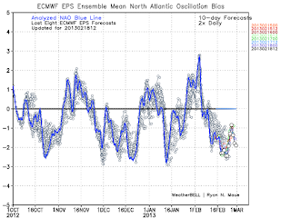
Now to the weather...its Feb 18th is winter over???? Hell no, well at least not from a pattern perspective. The weather pattern over the next 3 weeks should turn out to be a snow lovers affair for the eastern part of the country  Now whether or not that happens in your backyard is always an issue. The reason I say the pattern will be active and give us shots at snow is because of the North Atlantic Oscillation Index which is going to stay in a very negative phase. The negative phase this time of year favors storms to develop over the eastern united states. Take a look...


As you can see the NAO as depicted in this graph will stay sharply negative into march. This results in an upper air patter like this...


You do not need to know how to read this map just know that the dark red region over eastern Canada is blocking high pressure. This blocking high pressure is the negative NAO and results in storms not being able to escape to the north and instead reforming on the Atlantic coast. Think of a storm system being a leaf in a river it wants to flow to the area of least resistance, the high pressure to the north is upstream so storm will reform under it. This has always given us our greatest snowstorms especially this time of year.

So after we see some rain tomorrow night (possibly some snow showers on back end) when will it snow? Right now I like the setup for a redeveloping coastal storm for Sunday the 24th. Here is the region I think that will be effected at this point...


I highlighted the area that I beleive at this point will be effected by this potential storm. The further north and west you go within this blue shade right now is the best chance at frozen precip. This potential storm threat will originate from a storm that will move into the central part of the united states as shown below valid Thursday..


Now how does a storm in the middle of the country reform on the mid Atlantic coast your ask??? The answer is the negative NAO! Check this out..


This map shows areas of high pressure in light green and orange and low pressure in blue around 14k feet in the atmosphere. The same storm system shown on the surface map is shown here, the center of it being the purple region within the blue. Notice the green and orange to the north of it as marked by the "H" I drew in. Thats the blocking high pressure which stops the storm in its tracks and forces it to move and redevelop on the coast aided by an active southern stream. 

This is the setup that almost every model is showing right now. The question of course becomes where does the "L" or low pressure set up exactly. That will determine who is effected by this system and also who gets rain or snow. 

We are very far out form this event, and its not until mid week that I will begin to speculate on who will exactly stand a shot at accumulating snow..however, my confidence in this happening is pretty high right now. Let's wait and see. 

On a quick side note check this out...click to make each bigger


On the left was my snowfall map released for the big storm a week ago 3 days before it came, and on the right is a new map a found that shows the total tally's for the storm...not too bad right??

I have to brag on this one because I will not get them all right to this degree, so I will enjoy it while its lasts...

If the storm on the 24th does not work out we have evident of a whole lot more behind it heading into March, I find it hard to believe we will not see one more big storm on east coast....lets zone in on the 24th first...

More tomorrow 

Monday am: Quick Snapshot at Week Ahead

Good Morning. I have been on the road since Friday, so I have not had as much time as I wanted to update. At the end of the day I will be able to post in more detail, but for now here is what I am looking at. Despite the fact we are close to the end of winter, there still is alot of potential in the atmosphere. A parade of storms will march through the US over the next two week, and chances are one of them will reform on the east coast giving us one more shot at snow. This first chance at this happening is on Friday, but it is far from a certainty and there is not alot of model agreement. If it does occur it will be from an inland storm in the ohio valley redeveloping a low over VA capes. Prior to this, we will see a little rain on Tuesday which possibly some snow showers on the back end. Most of this week will have cold and blustery conditions with temps in the 30's.

When I am back home tonight I will evaluate when I believe our next best shot at snow is and have some graphics to go along with it...check in then

Saturday, February 16, 2013

Saturday 2pm..storm misses our area but will rage in cape cod

A very impressive storm that I have talked about all week did end up trending more west, but still will miss us and instead give cape cod and Maine second blizzard in 10 days. Tomorrow night I will post on the active stormy pattern we will have to close out February next week. Be sure to check in..

Friday, February 15, 2013

Quick update

Final forecast for weekend: light snow tonight over by the morning. Big storm will stay offshore and not effect our region. It was a close call but models must be trusted at this point so I am throwing in the towel


Just expect colder windy conditions for weekend. Next week very active w two shots at snow. More on that this weekend. We should see one more decent storm before its all said and done. Enjoy weekend.

Friday Morning Update

What a forecast this will be, its not to often that a forecast is this complicated. I recommend watching last nights video that goes into detail on the weekend situation. Last nights runs of the models after I cut the video did not back off on the threat of a close call for snow this weekend, but before I get to that lets get to what I do know which is that some snow will spread into our area tonight. 

Light Snow will spread into the area around 9pm and last through the night ending before daybreak.  Expect accumulations throughout our forecast area on the order of 1-2 inches maybe a little more for higher elevations of northwest jersey. Now that's the easy part of forecast.

The big question, which I showed in the video last night is does a bigger storm come close enough to our area to effect us Saturday and Sunday. Believe it or not a massive storm is going to form just off the Atlantic coast, but models just have it give us a glancing blow- maybe adding on an inch to what we get Friday night and up in new England a few inches (3-5). I am still uneasy about this due to the fact all week the models have had no handle on this situation. Yesterday the american model had it way out to sea and now this morning its setting up 100 miles closer to the coast. I am afraid this trend will continue and the runs today will affirm this. I do not think we will get a big snowstorm, but this system giving us a little more than a glancing blow, possibly a moderate accumulation is not out of the question. If this was to occur the time frame would be later Saturday night into Sunday. This is a low confidence forecast for Sat night into Sunday so for now, do not plan for there to be a storm. Just make sure you keep checking in to this blog especially later tonight to get a better idea of what will actually happen. By tonight the situation should be locked in and there will be no surprises.

Thursday, February 14, 2013

Thursday PM Video Update

Afternoon Models Trending for The Storm..we now await euro

GFS Canadian British Nam now all have a snow event for Saturday that can potentially be decent accumulations..we await euro at 2. It would be pretty neat to see this storm come back to life if you been following my posts since Monday at the potential. Detailed update tonight.

Thursday AM: Weekend is Not off The Table For Snow!

I'm am going to post in great detail this evening, but the weekend storm is still in play! The models are now starting to converge on a low developing on an Arctic front on Saturday and having it track up the east coast. If you read the models literally, it gives us a moderate snow event with high ratio snows, but we still have a few days to go and the models can still result in a more progressive solution. Now I cannot say it will snow 100% at this time, but I can say that now you know why I will not give up on an event I believe can happen until I have no more evidence to support my prediction. Last nights model runs tipped the scale back in my favor and we got something to track now. A trend to a stronger solution would not surprise me at this point.

Check in tonight for the detailed breakdown on if this will happen and also what next week will look like in terms of a few storm threats on the maps.

Until then..


Wednesday, February 13, 2013

Still Got A Shot at Weekend Storm

Don't give up yet if you want snow. British model has big storm and models that do not have it only need a few variables to change slightly. More on this late tonight check In.

Tuesday, February 12, 2013

Tuesday Night Video: Light Snow Tomorrow, Weekend Threat??

Tuesday Am: Brief Update on Tomorrow

Good morning, I wanted to make a quick update on the snow situation for tomorrow and my thoughts for the weekend system. Overall, I like where my snowfall map shows the core of the snow for tomorrow night and the timing. I might have to tweak the amounts down however to the 2-4 inch range from the 5-7. I am not seeing the liquid precipitation amounts I would want at this time, so I will take a closer look at this after this afternoons updates come in and see if I have to update map. Regardless, snow will fall tomorrow night and be over in time for them to hopefully clean things up for the commute on Thursday morning. This is nothing to get overly excited about in the shadow of last weekends system.

I am still keeping my eye on the weekend storm threat for the east coast. There is a lack of any model agreement. Right now the Canadian model is by far the bullish with developing a storm, and the other models are lagging behind the Canadian. If only the Canadian was a reliable model then there would be reason to get excited. However, if you want a big storm there is some glimmer of hope....even though the core European model has the storm developing too far off in the ocean, its ensemble runs have the storm closer to the coast giving us a chance at accumulating snow. (an ensemble is the base model run with different variations of inputs to test it against possible points of error.) Still however, no models at this time are as strong as the Canadian but that can always change. If your curious what the Canadian looks like here you go...


I think a storm will develop closer to the coast this weekend due to a few large scale climate signals I look at, but I am going to stop my thought process there because your guess is as good as mine when it comes to intensity. I want to see the European operational model come into agreement with its ensembles. If that occurs that is a good sign for this storm to form.

Check in tonight for finalized snowfall map and additional updates for weekend..


Monday, February 11, 2013

Monday PM: Snowfall Map up for Wednesday...Whats Ticking for The Weekend?

Good evening. As I promised here is the update for the snow event Wednesday and a closer look at this weekend. 

Starting with the snow event..snow will spread into our region late Wednesday afternoon and last until early Thursday morning. The models originally had this as a southern storm, but as expected have started their correction northward and are setting up in a common spot of the NJ coast. This will be a nice MODERATE snow event with accumulations ranging from 3 to as high as 8 inches in some local spots.

Here is the GFS model, which in this case is my model of choice for this event as I like how it has lined up in comparison with the other models.  I hate to say it, but the European seems late to the party on this one...lagging behind making a slow correction northward.


Not a real powerful storm, but a nice snow maker. Here are my expected accumulations at this time...


Now, once this clears through there can be some mischief on the horizon for late this weekend. A super trough is going to dig down into the entire eastern third of the country late this week...


Anytime the jet stream goes to this extreme and dives this far south into the gulf of mexico one has to be on the lookout (the polar jet stream basically is outlined in blue). First off, it is rare for a trough of this magnitude to form. If energy from the jet stream in mexico (southern jet) manages to merge with energy from the polar jet stream now sitting in the gulf of mexico literally a bomb can go off on the east coast. This is due to the fact a storm can form earlier and further south giving it time to mature on its way up the coast and reach peak intensity by the time it gets to new England. The models have began to hint at a scenario that would form a massive storm somewhere in the east ranging from just off the east coast to out in the Atlantic ocean. All I want to do today is show how there are players on the table for that to occur. Whether or not it will occur is up to mother nature and if I begin to see any trend or agreement in the models for the extreme solution of a super storm occurring I will be the first to let you know. I will not however start speculating based on one run of a model showing a huge storm. Just keep checking in and I will update if there is any reason for concern this weekend..

Next update coming tomorrow morning thanks for reading..


Monday AM..Possible Snow Event Wed into Thursday, Weekend Looks Interesting

Brief post, there will be much more detail this evening. I am gaining confidence that our region will see a snow event on Wednesday. This originally was supposed to be a southern storm but it has started to trend north on models. If things materialize correctly it is capiable of producing accumulating snow that will effect travel. The question is how far north the precip action shield will get and if north jersey will be in the main accumulating snow. I will post in much more detail tonight so check in..Also over the weekend we will have a very favorable setup for rapid storm development over the east coast. This by no means is a prediction of a storm at this time but I wanted to make the point things in the upper atmosphere look compelling.

I will cover this set up tonight as well..check in around 8pm

Friday, February 8, 2013

11:30 Final Update

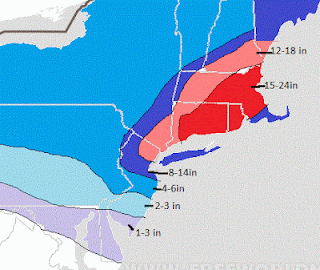
The height of the storm will be from 1am-3:30am tonight. Snow will accumulate several inches before tapering off by daybreak. When it is all said and done our area will have seen 8-14 inches total depending on who sets up in heavy bands. Up in New England there will be amounts over 30 in.

Tomorrow I will summarize the results of the storm and talk about the next storm that looks to want to materialize Wed into Thurs this week. That storm can be a strong one too...we are in that kind of pattern for the next 4 week.

Thanks for checking in guys..

Snow Will Return Tonight For North Jersey! Don't Jump


8:40 update: radar over north jersey filling in! Here will come the storm for our area over the next 7 hours

Next update 11:30pm

Heaviest Snow Will Fall 10pm to 4am.

3 PM Brief

The storm will now start to really crank up. Snow rates have intensified in our northern counties and expect this to continue through the afternoon and picking up to intense snows tonight. Areas that have seen rain will start to change to snow. Places in western Jersey and eastern PA will start to fill and and light snow will turn into moderate snow.

Now would be a good time to get off roads..

Tune in later for evening video update around 6

Noon Update: On Track

Updates Throughout Day

Good Morning...Today is all going to come down to observations. Some models have gone a little more east with the storm last night which keeps us more around the 12in mark for today. In these cases you just have to look at the radar and satellite to see how the storm is actually moving compared to how it is supposed to.

Snow will begin to pick up in the area and possibly change over to some rain near city before changing back to snow later this afternoon, so do not be thrown off if it starts to rain that is part of the equation for our eastern zones. The height of this storm will be late this afternoon and tonight, and it should be over by daybreak Saturday or linger a little into the morning.. Snow has started to fall in many areas and will begin to stick as morning goes on so be careful.

Here is my original map which looks like a good projection of how this will unfold.


Keep in mind there will be many surprises to upside and downside with this system, it all depends on how things look to develop over next few hours.

More coming around noon check in...

Thursday, February 7, 2013

Final Forecast on Tomorrow's Historical Storm


Here is my latest on this storm, overall my ideas have not changed much since last night, but I wanted to drill down into a few specifics due to the fact the storm starts tomorrow. As a side note its unbelievable to me how much of a joke the weather channel is. They had 1-3 inches up this afternoon where now they are blowing the horns and whistles about an epic storm..how can anyone take their act seriously.

Here is my latest snowfall map which is discussed in video..


This was map I made Tuesday night...


Blend the two and you have a good bet on what can happen with this storm.

I will update more late tonight and tomorrow as storm gets going...take this one seriously


Detailed Final Update Tonight at 8:15

New Euro Out..Historic Blizzard Looking Immenent 1 to 2 ft

New euro truly historic all of north jersey and NYC 1 to 2 feet of snow..central nj 12 inches..unbelievable..updated video and snowfall map coming this evening.

Wednesday, February 6, 2013

Thursday Morning: Video From Last Night On Storm


CLICK HERE IF NO VIDEO ON SCREEN

This video overviews my latest assessment of the major storm developing for Friday into Saturday. Keep in mind that this is a high confidence forecast for Mass, CT, and RI. For North Jersey and NYC however, I will explain in the video the complexities that will make this forecast a challenge. Keep checking in daily for latest updates as new data comes in daily.

Update at 7:30am Thursday:

Overall after looking at the models that came in early this morning I like my overall idea I laid out in the video last night.  I think if you stick to the snowfall map I posted on Tuesday night that will end up being an accurate depiction of what is going to unfold. Latest runs since I cut the video now show in many cases a colder storm which can give NYC 6-12+ and interior North Jersey even 12-18. Central jersey looks like a 6-10 in a colder scenario from my base case. In the extreme case the Boston area can see over 3ft of snow from this. I will issue one more final map tonight which will be the one to go by, but I would be surprised if it changed much to the downside from my original posted Tuesday night which is this...


Check in throughout the day and tonight for updates, but this looks to be a historical storm for our region and should not be taken lightly. Timing will be Friday morning through Sat Morning...picking up in intensity Friday afternoon to its peak Friday night from 11pm-3am. If anything I have a gut feeling I might have to up these amounts, but lets not get ahead of ourselves.

Now as an aside...this is why I created this blog because of poor forecasting like this..

Weather Channel Snowfall Map Issued Yesterday...(yes that's 1-3 inches for us)


Their brilliant forecast...

Rain and snow in the morning turning to rain in the afternoon. High 37F. Winds NE at 10-15 mph. Chance of precip 80%

Now here comes the flip flop...today's map


Today's Forecast

Rain and snow in the evening turning to all snow late. Low 21F. Winds N at 15 to 25 mph. Chance of snow 90%. Snow accumulating 5 to 8 inches.

So in less than 24hrs we go from 1-3 inches to 5-8 inches. I am just showing this to illustrate how alot of these commercial weather networks do not put any human insight into weather forecasting anymore. They just look at what ever the American model is showing for that day and then render a graphic and text forecast to the computers output. They rather focus on their marketing and theater with naming their storms, bringing on all these so called experts and removing all of the true forecasting out of the equation. This is the sole purpose I created this blog. I will not always be right, but at least in many cases I can keep you days ahead of this nowcasting that you are seeing. And the national weather service is not much better. They went from rain to 5-10 inches in the last 24 hrs. 

Check in throughout the day that's all for now...


National Weather Service Finally Jumping on the Bandwagon, Weather Channel Still Finding Nemo


..WINTER STORM WATCH IN EFFECT FROM FRIDAY AFTERNOON THROUGH
SATURDAY MORNING...

THE NATIONAL WEATHER SERVICE IN MOUNT HOLLY HAS ISSUED A WINTER
STORM WATCH, WHICH IS IN EFFECT FROM FRIDAY AFTERNOON THROUGH
SATURDAY MORNING.

* HAZARD TYPES...HEAVY SNOW. THE SNOW SHOULD MIX WITH OR CHANGE TO
  SLEET AND RAIN FOR A TIME ACROSS AT LEAST PORTIONS OF THE AREA.

* ACCUMULATIONS...5 TO 10 INCHES OF SNOW POSSIBLE. THE HIGHEST
  AMOUNTS MAINLY TOWARD NORTHWESTERN NEW JERSEY INTO THE POCONOS.


Now for The Weather Channel...

All they seem to be focusing on is naming these storms..This one they call "nemo"

Rain and snow in the morning turning to rain in the afternoon. High 37F. Winds NE at 10 to 15 mph. Chance of precip 80%.


The amounts for northern Vermont and Northern Maine are way off in left field  no way they get over a foot. Ok so they nailed Boston with 1-2 feet but that's the easiest part of this forecast, not much room for error there. Now 1-3 inches for all of north Jersey southern NY and CT???? If this storms a bust they will be right, but last time I checked your supposed to forecast on the likely scenario which is more like 6-12 for these regions. I do not understand who's in charge over there, then again since the they have been  bought by NBC all they are concerned with is pushing "global warming" propaganda.

In all seriousness the more I look at this for Southern New England the more it looks to be a all out crippling event with snows of 20-30 inches and winds gusting up to 60 mph. I will cut a video tonight. 


Afternoon Update: New Euro In

The new run of the European model is in. Overall not much has changed from my original ideas. Like I clearly mentioned in my last post the North Jersey area is a battleground because it is right now the threshold of where the storm is coming together. Thus, any slight shift in the dynamics means more or less snow than I have. The new run of euro verifies all my snow amounts up in southeastern New England where someone is going to get over 2 ft. For us, the current run has North Jersey (I-80 northward) in a healthy band of 6-8 inches. That is a little below my initial projection, but I am not going to change my map yet. For timing the storm now looks like it will be a Friday afternoon to Saturday morning event, heaviest at night. We are literally talking about a margin or error of 30 miles for if we get the real heavy snow or not. All three waves responsible for this storm need to merge sooner rather than later. As you can see, the models are going back and forth but if you average the runs we are left with a good shot at decent snow for our northern counties. I will update again around 11 pm tonight.

Historic Snowstorm Shaping Up for Friday Similar to Lindsay Storm of 1969

Good Morning...we are in for what now looks to be a very serious potentially crippleing storm Friday if the latest run of the European model is correct. As an abstract I am talking about a swath of 1-2 Feet from north jersey through CT up into eastern Mass. Its funny because I have been following the European model on this storm all week and it has gotten stronger and stronger every run. Last night I actually made a post prior to the new run just using the American model, but it is clear if this storm verifies the European is a superior model. Here is what we are POTENTIALLY looking at if the European is correct.


As seen, this would be no joke with amounts easily over a ft in many places with moderate winds creating possible blizzard conditions at times. I do not like to over hype things, but this does have potential to produce the snowfall shown above. I think The Boston area is locked in high probability event at this point, same with CT and Mass. NJ might be a little more tricky when it comes to the big amounts I showed because its all gonna depend on how the storm comes together at the last second but that is a good illustration for now. The amounts could be more or less for North Jersey if things change in next two days.

Here is what the European model looks like for Saturday at 1am, the height of the storm:


For those of you who are interested look at the Lindsay Storm of 1969 that ironically occurred on the same date and it is extremely similar to this potential setup.  Here were the snow totals for that storm (click to make bigger):


I showed last night the 4 factors that need to come together perfectly for this storm to materialize as the European is now showing..be sure to check that post out if you want more info.

Right now it looks like snow will start close to 1 pm Friday and last until Saturday late morning, accumulating the most in the overnight hours where blizzard conditions will be very possible. I will update again tonight after today's runs of the modeling, Be sure to keep checking to get up to date data and information on this developing situation. I do not think this will be over hyped for the Boston area, its our area that we have to keep a close eye on, but for now watch out...


Tuesday, February 5, 2013

Tuesday Night Update on Fridays Storm

The new European does not come out until 2:30am, but I just had a chance to look at the new run of the American model (GFS) and its coming into better agreement with the consistency of the European. Its safe to say a big storm is coming...ground zero still looks to be the Boston area with an easy 12-15 inches of snow 

This storm system is very complex and actually involves 4 features that need to come together perfectly in order for our area to get snow. In the current state they appear to do so, but for those of you who are interested, lets take a look at what those features are (click to make bigger).


This map represents cyclonic winds in the upper atmosphere which helps see where different areas of instability are. These areas combine to create strong storms at the surface.

 Part 1 is the pacific trough which will help amply the eastern trough and pull the remaining three pieces together. We have piece 2 which is the lagging southern stream energy which will speed up and combine with piece 3. The key will be when the last part of this recipe which is piece 4 coming in from Canada chooses to phase with 2 and 3. If this phasing occurs a little late then the storm will develop further to the north and east sparing our area of any significant  snow. If however, it phases much earlier then we are looking at very high snow totals in interior counties which would range from 8-14 inches. RIGHT NOW THE MODELS ARE IN BETWEEN with the phasing so what we are left with is a storm that develops just to our south and rapidly intensifies as it approaches ground zero which is Boston area. This of course can change due to the complexities explained above. I

As I said, it is a very tricky forecast but I will say I am very confident in the amounts around Boston, CT, and Interior NY/  North Jersey. Elsewhere especially around I-80 its going to come down to a difference in 30 miles on how those features I explained above choose to phase. 

February is going to be an active month so if for some reason we miss this one, we have another storm on Valentines day right behind it. I think that my original prediction from December of 2 east coast storms will pan out when it is all said and done. Lets focus on this storm first.... 

Check in a few times daily for any updates on these amounts as they can change...

That's all for now, more tomorrow


MAJOR NEW ENGLAND SNOWSTORM LOOKING IMMINENT

I do not have time to post in detail so be sure to check in tonight around 11pm but the storm for Friday looks to be a major winter weather event possibly historic for parts of CT and Mass. Snow amounts of 15 to 30 inches possible in those areas.

For NJ looking like snow to rain changing back to snow south of I95  with a few inches and amounts ranging from 4 to 10 inches north and west of 95. The European model is locked in on this storm and the news media will begin to hype it tonight. I wil issue my snowfall map tonight at 11. Be sure to check in

Tuesday: Biggest Snows of Season Looking Likely Friday

Good Morning...I mentioned yesterday that Friday was starting to look promising for the threat of some decent snow and my idea has become more solidified since then. The European model has now locked in for 5 runs in a row the idea of a real snowstorm for the northeast. By real snowstorm I mean a storm that is more dynamic in nature and that develops off the coast. The american and Canadian models have now started to agree with the European model on this event along with the British model.  We are looking at an event that would start on Friday morning and last until the evening. Here is what the Euro model looks like for Friday...


This gives everyone from Phili upward a shot at accumulating snow over 4 inches and higher amounts of 6in plus to the north and west.  Right now looks like the Boston area could be ground zero with 12in plus of snow. So that's what the model says whats my take?

I think that this storm will develop as the European shows. I think snowfall amounts will range from a few inches near the coast to possibly over 6 inches the further north and west you go. I will probably post a snowfall map late tonight and zone in more on exactly where I think those amounts will occur, so keep checking in for updates on this up until Friday.

Regardless if this storm pans out as I expect, Feb is looking more and more promising for winter weather in terms of the overall weather pattern. In fact another storm system looks like it wants to materialize around valentines day.

Check in late tonight for an update for Friday...

Monday, February 4, 2013

Monday Morning: Joe Flacco Pulls it Off, Now Can It Snow on Friday?

Good Morning. It was a good game last night, gotta tip your hat to Joe Flacco and the Ravens for what this did these last few weeks..great football to watch. 

This week will be a cold week in general with some light snow showers Tuesday and Wednesday. However, I have my sights on Friday for a true potential east coast snowstorm for our area. Right now the European model, which is the most accurate has had the storm for three runs in a row. American model has not had the storm at all and sheers all the energy out to sea (known to do that). The 3rd model in terms of accuracy is the British model and that model is starting to see the storm like the European.

I am going to keep a close eye on this, and see if the American and Canadian models start to agree with the european and british. Taking my bias out of it, you cannot ignore the european model verifying an event 3 times in a row so I am leaning more towards a weather event for Friday.

I will post more on this late tonight...will winter finally bear down on us?